 view gallery view gallery W31.9 km W31.9 km
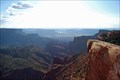
|   Top of the World - Moab, Utah Top of the World - Moab, Utah
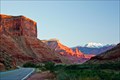
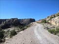
in Scenic Roadside Look-Outs The view from Top of the World is one of the most dramatic in the Moab area. From here, you can look out over the valley to Fisher Towers, the La Sal Mountains, Priest and Nun formations in Castle Valley, Arches National Park and western Colorado. posted by:  94RedRover 94RedRover location: Utah date approved: 10/29/2008 last visited: 02/26/2010 |
 view gallery view galleryW31.9 km |  Top of the World Overlook - Moab, Utah Top of the World Overlook - Moab, Utah
in Scenic Overlooks The view from Top of the World is one of the most dramatic in the Moab area. From here, you can look out over the valley to Fisher Towers, the La Sal Mountains, Priest and Nun formations in Castle Valley, Arches National Park and western Colorado. posted by: 94RedRover location: Utah date approved: 10/23/2008 last visited: 02/26/2010 |
 view gallery view gallery NW38.1 km NW38.1 km
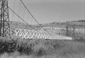
|  Kokopelli Trail ~ Dewey Bridge Trailhead Kokopelli Trail ~ Dewey Bridge Trailhead
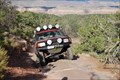
in Offroad Trails Although the Kokopelli Trail was formally established as a mountain biking trail, only about 10% is single-track closed to 4x4 vehicles. posted by:  brwhiz brwhiz location: Utah date approved: 04/04/2012 last visited: 02/06/2014 |
 view gallery view galleryNW38.1 km |  Dewey Suspension Bridge Dewey Suspension Bridge
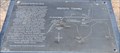
in Utah Historical Markers The Dewey Bridge was destroyed by an accidental fire not long after it was restored in 2000. posted by: brwhiz location: Utah date approved: 04/05/2012 last visited: 11/23/2022 |
 view gallery view galleryNW38.1 km |  Kokopelli Trail ~ Dewey Bridge Trailhead Kokopelli Trail ~ Dewey Bridge Trailhead
in Hiking and walking trailheads The Dewey Bridge is a convenient trailhead for meeting support vehicles on the 142-mile long multi-use Kokopelli Trail in Western Colorado and Eastern Utah. posted by: brwhiz location: Utah date approved: 04/05/2012 last visited: 02/05/2014 |
 view gallery view galleryNW38.1 km | Dewey School Site in Utah Historical Markers The school at Dewey had a relatively short life of only 12 years. posted by: brwhiz location: Utah date approved: 04/05/2012 last visited: 04/07/2016 |
 view gallery view galleryNW38.1 km |  First School in Dewey, Utah First School in Dewey, Utah
in First of its Kind The first school in Dewey was held in the Wheeler's log cabin. posted by: brwhiz location: Utah date approved: 04/04/2012 last visited: 04/07/2016 |
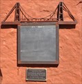
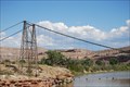
 view gallery view galleryNW38.3 km | Dewey Bridge - Moab, Utah in Scenic Roadside Look-Outs Built in 1916 by the Midland Bridge Company of Kansas City, Missouri, Dewey's Bridge was the longest suspension bridge in Utah. The span of 500 feet was at the time of it's construction, the second longest span west of the Mississippi. posted by: 94RedRover location: Utah date approved: 11/18/2008 last visited: 11/23/2022 |
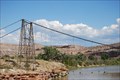 view gallery view galleryNW38.3 km |  Dewey Bridge - Moab, Utah Dewey Bridge - Moab, Utah
in U.S. National Register of Historic Places Built in 1916 by the Midland Bridge Company of Kansas City, Missouri, Dewey Bridge was the longest suspension bridge in Utah. The span of 500 feet was at the time of it's construction, the second longest span west of the Mississippi. posted by: 94RedRover location: Utah date approved: 10/28/2008 last visited: 11/23/2022 |
 view gallery view galleryNW38.3 km |  Dewey, Utah - Longest Wooden Suspension Bridge in Utah Dewey, Utah - Longest Wooden Suspension Bridge in Utah
in Roadside Attractions Built in 1916 by the Midland Bridge Company of Kansas City, Missouri, Dewey Bridge was the longest suspension bridge in Utah. The span of 500 feet was at the time of it's construction, the second longest span west of the Mississippi. posted by: 94RedRover location: Utah date approved: 06/23/2009 last visited: 11/23/2022 |
 view gallery view galleryNW38.3 km |  Dewey Bridge - Moab, Utah Dewey Bridge - Moab, Utah
in Suspension Bridges Built in 1916 by the Midland Bridge Company of Kansas City, Missouri, Dewey's Bridge was the longest suspension bridge in Utah. The span of 500 feet was at the time of it's construction, the second longest span west of the Mississippi. posted by: 94RedRover location: Utah date approved: 10/28/2008 last visited: 11/23/2022 |
 view gallery view galleryNW38.3 km |  Dewey Bridge - Moab, Utah Dewey Bridge - Moab, Utah
in Photos Then and Now Built in 1916 by the Midland Bridge Company of Kansas City, Missouri, Dewey's Bridge was the longest suspension bridge in Utah. The span of 500 feet was at the time of it's construction, the second longest span west of the Mississippi. posted by: 94RedRover location: Utah date approved: 10/28/2008 last visited: 11/23/2022 |
 view gallery view galleryNW38.3 km |  Dewey Bridge - Moab, Utah Dewey Bridge - Moab, Utah
in Orphaned Bridges Built in 1916 by the Midland Bridge Company of Kansas City, Missouri, Dewey's Bridge was the longest suspension bridge in Utah. The span of 500 feet was at the time of it's construction, the second longest span west of the Mississippi. posted by: 94RedRover location: Utah date approved: 10/29/2008 last visited: 11/23/2022 |
 view gallery view galleryNW38.3 km |  LONGEST - Suspension & Clear Span Bridge in Utah LONGEST - Suspension & Clear Span Bridge in Utah
in Superlatives Built in 1916 by the Midland Bridge Company of Kansas City, Missouri, Dewey Bridge is the longest suspension bridge in Utah. It is also the longest clear span bridge in Utah. posted by: 94RedRover location: Utah date approved: 11/23/2008 last visited: 11/23/2022 |
 view gallery view galleryNW38.3 km |  Dewey Bridge - Dewey, UT Dewey Bridge - Dewey, UT
in American Guide Series Built in 1916 by the Midland Bridge Company of Kansas City, Missouri, Dewey Bridge was the longest suspension bridge in Utah. The span of 500 feet was at the time of it's construction, the second longest span west of the Mississippi. posted by: 94RedRover location: Utah date approved: 03/17/2009 last visited: 11/23/2022 |
 view gallery view galleryNW38.3 km | Top of the World - Moab, Utah in Offroad Trails This trail offers beautiful scenery and some challenging obstacles. The overlook is not one to be missed. posted by: 94RedRover location: Utah date approved: 10/21/2008 last visited: 02/26/2010 |
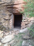 view gallery view galleryNW38.3 km | ") Rock Room at Dewey Bridge, Grand County, Utah Rock Room at Dewey Bridge, Grand County, Utah
in Cave Entrances (Artificial) The Rock Room at Dewey Bridge is a mystery, but is easy to locate once you visit the Dewey Bridge Historical Site. It is a Man Made Cave with a Man Made (Artificial) Entrance. posted by: condor1 location: Utah date approved: 05/28/2016 last visited: 04/23/2016 |
 view gallery view galleryW38.9 km |  Dinosaur Diamond Prehistoric Hwy - Fisher Towers - Utah, USA Dinosaur Diamond Prehistoric Hwy - Fisher Towers - Utah, USA
in National Scenic Byways Utah State Route 128 is listed both as part of the "Dinosaur Diamond Prehistoric Hwy" of the National Scenic Byways program and as "Upper Colorado River Scenic Byway" by the State of Utah. posted by: netdust location: Utah date approved: 12/29/2014 last visited: 11/23/2022 |
 view gallery view gallery NE43.5 km NE43.5 km
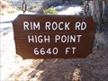
|  Rim Rock Road High Point - 6640' Rim Rock Road High Point - 6640'
in Elevation Signs The high point of the drive through Colorado National Monument. posted by: WR7X location: Colorado date approved: 11/14/2013 last visited: never |
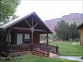 view gallery view galleryW44.9 km |  Castle Valley Inn - Moab, UT Castle Valley Inn - Moab, UT
in Bed and Breakfast Located in a dramatic high desert valley at 5000 feet, the skyline immediately south of the Inn is dominated by the lofty La Sal Mountains. posted by: RakeInTheCache location: Utah date approved: 10/26/2016 last visited: never |
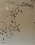
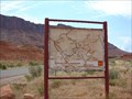 view gallery view galleryW44.9 km |  La Sal You Are Here Map La Sal You Are Here Map
in 'You Are Here' Maps You Are Here map near Moab, Utah. posted by: JacobBarlow location: Utah date approved: 08/28/2007 last visited: 10/19/2011 |
 W45.4 km |  Porcupine Rim Porcupine Rim
in Mountain Bike Trailheads A must do classic of Moab, 15.6 miles (requires shuttle). Outstanding views, expert sections and awesome singletrack. Fee area posted by: susy1313 location: Utah date approved: 10/17/2005 last visited: 02/26/2010 |
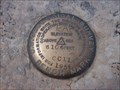 view gallery view galleryNE46.2 km |  Cold Shivers Point - USGS CC11 1934 Cold Shivers Point - USGS CC11 1934
in U.S. Benchmarks A gem of a bench mark which is located in the Colorado National Monument at Cold Shivers Point. posted by: king.hubi location: Colorado date approved: 06/10/2009 last visited: 09/15/2018 |
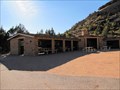 view gallery view galleryNE47.3 km | Devils Kitchen Picnic Shelter - Grand Junction, CO in U.S. National Register of Historic Places This picnic area was repaired after vandalism in 2009 in preparation for the Colorado National Monument's 100th anniversary in 2011. posted by: Outspoken1 location: Colorado date approved: 10/26/2011 last visited: never |
 view gallery view galleryNE47.3 km | Serpents Trail - Grand Junction, CO in U.S. National Register of Historic Places Once the only road through the Colorado National Monument, a portion has been saved as a hiking trail. posted by: Outspoken1 location: Colorado date approved: 10/26/2011 last visited: 09/16/2014 |
|