 view gallery view gallery W0.2 km W0.2 km
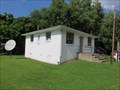
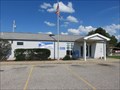
|   Glenwood WV 25520 Post Office Glenwood WV 25520 Post Office
in U.S. Post Offices Ashton WV Post Office posted by:  dukemartin dukemartin location: West Virginia date approved: 08/24/2017 last visited: never |
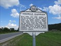 view gallery view galleryW2.1 km |  Thomas Hannan Thomas Hannan
in West Virginia Historical Markers A quick history about Thomas Hannan. posted by: dukemartin location: West Virginia date approved: 08/22/2017 last visited: 08/22/2017 |
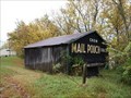
 view gallery view gallery N3.2 km N3.2 km
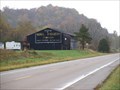
|  Mail Pouch barn - MPB 35-27-02 Mail Pouch barn - MPB 35-27-02
in Barns Mail Pouch barn in Gallia County, OH posted by:  Wallyum Wallyum location: Ohio date approved: 04/08/2021 last visited: never |
 view gallery view gallery NE4.3 km NE4.3 km
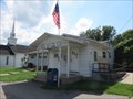
| Ashton WV 25503 Post Office in U.S. Post Offices Ashton WV Post Office posted by: dukemartin location: West Virginia date approved: 08/24/2017 last visited: never |
 view gallery view galleryW5.3 km |  Albert Gallatin JenkinsHome of a General - Glenwood WV Albert Gallatin JenkinsHome of a General - Glenwood WV
in U.S. Civil War Sites Marker is in Glenwood, West Virginia, in Mason County. Marker can be reached from the intersection of Ohio River Road (West Virginia Route 2) and Homestead Road. Glenwood WV 25520 posted by: Don.Morfe location: West Virginia date approved: 07/08/2023 last visited: 07/08/2023 |
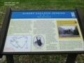 view gallery view galleryW5.3 km | Albert Gallatin Jenkins-Home of a General - Glenwood WV in Civil War Discovery Trail Sites This was the childhood home of Albert Gallatin Jenkins. He was born in 1830 and was educated at Marshall Academy, Jefferson College, and Harvard Law School. posted by: Don.Morfe location: West Virginia date approved: 08/22/2020 last visited: 10/04/2021 |
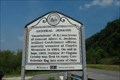 view gallery view galleryW5.3 km | General Jenkins in West Virginia Historical Markers General Jenkins posted by: jrappold location: West Virginia date approved: 08/20/2007 last visited: 03/22/2023 |
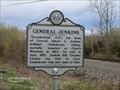 view gallery view galleryW5.3 km |  General Jenkins - Glenwood WV General Jenkins - Glenwood WV
in Specific Veteran Memorials "Greenbottom" (N.E.) was home of General Albert G. Jenkins, brilliant Confederate officer, mortally wounded at Cloyd's Mountain in 1864. posted by: Don.Morfe location: West Virginia date approved: 03/24/2023 last visited: 03/22/2023 |
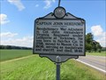 view gallery view galleryN6.9 km | Captain John Hereford / Mercer's Bottom in West Virginia Historical Markers A two sided sign telling about two officers in the Revolutionary Army. posted by: dukemartin location: West Virginia date approved: 08/22/2017 last visited: 08/22/2017 |
 view gallery view galleryN8.2 km | Apple Grove WV 25502 Post Office in U.S. Post Offices Apple Grove WV Post Office posted by: dukemartin location: West Virginia date approved: 08/24/2017 last visited: never |
 view gallery view galleryN8.4 km | Mail Pouch barn - MPB 35-27-03 in Barns Mail Pouch bar in Gallia County, OH posted by: Wallyum location: Ohio date approved: 04/08/2021 last visited: never |
 view gallery view galleryW9.2 km |  Wesleyan Church - Crown City, OH Wesleyan Church - Crown City, OH
in Wesleyan Churches This Wesleyan Church is located in the small town of Crown City, Ohio, on Route 7 along the Ohio River. posted by: silverquill location: Ohio date approved: 01/31/2009 last visited: never |
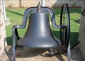 view gallery view galleryW9.2 km |  Wesleyan Church Bell - Crown City, OH Wesleyan Church Bell - Crown City, OH
in Bells This bell is on display outside the Wesleyan Church in the small community of Crown City, Ohio. Presumably it is from an older building that this 1997 house of worship replaced. posted by: silverquill location: Ohio date approved: 01/31/2009 last visited: never |
 view gallery view galleryN10 km |  Robert C. Byrd Locks & Dam Abutment Access - Gallipolis, OH Robert C. Byrd Locks & Dam Abutment Access - Gallipolis, OH
in Fishing Holes Coordinates are taken at the Abutment Access area on the Ohio side of this dam, near Gallipolis, Ohio. It was put into operation in 1937 with major upgrades in 1992. It is reputed to be one of the best fishing spots on the river. posted by: silverquill location: Ohio date approved: 01/31/2009 last visited: never |
 view gallery view galleryN10 km |  Robert C. Byrd Locks & Dam - Gallipolis, OH Robert C. Byrd Locks & Dam - Gallipolis, OH
in Waterway Locks, Planes and Lifts Coordinates are taken at the Abutment Access area on the Ohio side of this dam, near Gallipolis, Ohio. It was put into operation in 1937 with major upgrades in 1992, with two new parallel locks in the West Virginia side. posted by: silverquill location: Ohio date approved: 02/05/2009 last visited: never |
 view gallery view galleryN10 km |  Robert C. Byrd Locks & Dam - Gallipolis, OH Robert C. Byrd Locks & Dam - Gallipolis, OH
in Water Dams Coordinates are taken at the Abutment Access area on the Ohio side of this dam, near Gallipolis, Ohio. It was put into operation in 1937 with major upgrades in 1992, used primarily for barge navigation, but also hydroelctric production & recreation. posted by: silverquill location: Ohio date approved: 02/04/2009 last visited: never |
 view gallery view galleryN10 km |  Robert C. Byrd Locks & Dam - Gallipolis, OH Robert C. Byrd Locks & Dam - Gallipolis, OH
in People-Named Places First built in 1937, this dam spanning the Ohio River from West Virginia to Ohio is named for West Virginia Sen.Robert C. Bird, longest serving member of the U.S. Senate. Coordinates Abutment Access area on the Ohio side, near Gallipolis, Ohio. posted by: silverquill location: Ohio date approved: 02/01/2009 last visited: 07/14/2007 |
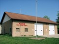 view gallery view gallery SW11.7 km SW11.7 km
|  Rome Vol. Fire Dept. Rome Vol. Fire Dept.
in Firehouses This is the rural Miller Station for the Rome Volunteer Fire Department. The main station for Rome Township is in Proctorsville, Ohio. This station is used primarily for brush fires and small structures. posted by: silverquill location: Ohio date approved: 01/31/2009 last visited: never |
 view gallery view gallerySW13.5 km |  Hillbilly Hot Dogs - Lesage, WV Hillbilly Hot Dogs - Lesage, WV
in Independent Hot Dog Restaurants What can I say..... This is Hillbilly Hotdogs, ONE OF A KIND...
If you pass it buy it will be your loss, stop and see the best FOLKS around.
As they say "The Best Hot Dog Stand in the land!"
posted by: The Finding Irish 4 location: West Virginia date approved: 09/17/2008 last visited: 11/27/2020 |
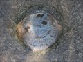 view gallery view gallerySW14.3 km |  HY2183 - W 331 - Lesage, WV HY2183 - W 331 - Lesage, WV
in U.S. Benchmarks A vertical control mark from the National Geodetic Survey (NGS) located along the Ohio River Road (aka Route 2) in Lesage, Cabell County, West Virginia. posted by: king.hubi location: West Virginia date approved: 09/15/2010 last visited: never |
 view gallery view gallerySW15.4 km |  Elevated ATV - Lesage, WV Elevated ATV - Lesage, WV
in Elevated Everyday Objects An ATV up in the air and in front of Rt.2 Storage LLC in Lesage, Cabell County, West Virginia. posted by: king.hubi location: West Virginia date approved: 09/14/2010 last visited: never |
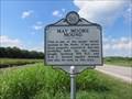 view gallery view galleryN16.4 km | May Moore Mound in West Virginia Historical Markers A quick statement about burial mounds in the area constructed by the Adena people. posted by: dukemartin location: West Virginia date approved: 08/22/2017 last visited: 08/22/2017 |
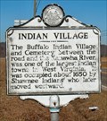 view gallery view gallery E16.6 km E16.6 km
| Indian Village/Excavations in West Virginia Historical Markers Indian Village/Excavations Putnam Co., WV posted by: two-bit Joe location: West Virginia date approved: 02/24/2007 last visited: 08/21/2017 |
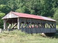 view gallery view galleryW17.5 km |  Scottstown Covered Bridge - Scottstown, OH Scottstown Covered Bridge - Scottstown, OH
in Covered Bridges This modified multiple King post covered bridge was built in 1874 with a span of 74 feet. It has been restored, but still shows considerble weathering and is not longer in use. posted by: silverquill location: Ohio date approved: 01/31/2009 last visited: never |
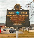 view gallery view gallery S18 km S18 km
|  U.S. Highway 60 - Milton, WV U.S. Highway 60 - Milton, WV
in Blue Star Memorial Highway Markers This Blue Star Memorial Highway Marker is located in Milton, WV posted by: two-bit Joe location: West Virginia date approved: 03/11/2007 last visited: 11/18/2011 |
|