 view gallery view gallery NW6 km NW6 km
|   Ransom CO-OP Grain Elevators West - Ransom, KS Ransom CO-OP Grain Elevators West - Ransom, KS
in Grain Elevators This grain elevator is a testament to the productivity of Kansas farmers - in Ransom, Kansas. posted by:  The Snowdog The Snowdog location: Kansas date approved: 07/11/2024 last visited: never |
 view gallery view galleryNW6 km | Ransom Co-Op Grain Elevators East - Ransom, KS in Grain Elevators The eastmost of two grain elevators in Ransom, Kansas. posted by: The Snowdog location: Kansas date approved: 07/11/2024 last visited: never |
 view gallery view galleryNW6.1 km |  Ransom Municipal Water Tank (JG0952) - Ransom, KS Ransom Municipal Water Tank (JG0952) - Ransom, KS
in U.S. Benchmarks This elevated tank is U.S. Benchmark JG0952 - in Ransom, Kansas. posted by: The Snowdog location: Kansas date approved: 07/08/2024 last visited: never |
 view gallery view galleryNW6.1 km |  Ransom Municipal Water Tank - Ransom, KS Ransom Municipal Water Tank - Ransom, KS
in Water Towers This elevated tank serves the residents of Ransom, Kansas. posted by: The Snowdog location: Kansas date approved: 07/08/2024 last visited: never |
 view gallery view galleryNW6.1 km | Ransom Co-Op Grain Elevators West (JG0954) - Ransom, KS in U.S. Benchmarks This grain elevator is U.S. Benchmark JG0954 - in Ransom, Kansas. posted by: The Snowdog location: Kansas date approved: 07/08/2024 last visited: never |
 view gallery view galleryNW14.6 km |  Utica Rural Fire Station #2 Utica Rural Fire Station #2
in Firehouses This red and white firehouse is in Arnold, Kansas. posted by: The Snowdog location: Kansas date approved: 07/07/2024 last visited: never |
 view gallery view gallery W14.6 km W14.6 km
|  Arnold Methodist Church - Arnold, KS Arnold Methodist Church - Arnold, KS
in Methodist Churches This neat red brick Methodist Church at the corner of Main and Highway 4 - in Arnold, Kansas. posted by: The Snowdog location: Kansas date approved: 07/07/2024 last visited: never |
 view gallery view galleryNW14.6 km | Arnold Elevator Company - Arnold, KS in Grain Elevators This elevator complex is on the north edge of Arnold, Kansas. posted by: The Snowdog location: Kansas date approved: 07/11/2024 last visited: never |
 view gallery view galleryNW14.6 km | Arnold Elevator Company (JH0662) - Arnold, KS in U.S. Benchmarks This elevator complex is on the north edge of Arnold, Kansas. posted by: The Snowdog location: Kansas date approved: 07/08/2024 last visited: never |
 view gallery view galleryNW15 km |  Arnold Cemetery - Arnold, KS Arnold Cemetery - Arnold, KS
in Worldwide Cemeteries This small cemetery is just north of Arnold, Kansas. posted by: The Snowdog location: Kansas date approved: 07/07/2024 last visited: never |
 view gallery view gallery N26.9 km N26.9 km
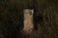
|  Cove 4 Rd BOD Marker Cove 4 Rd BOD Marker
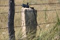
in Butterfield Overland Despatch Markers This BOD marker is on the north side of Cedar Bluff Res. It is .9 mile south of 270 and U RD. posted by:  Bridgerdigger Bridgerdigger location: Kansas date approved: 08/10/2007 last visited: 10/17/2010 |
 view gallery view galleryN27.2 km | Cove 2-3 Road BOD Marker in Butterfield Overland Despatch Markers This BOD marker is on the north side of Cedar Bluff Lake. posted by: Bridgerdigger location: Kansas date approved: 08/10/2007 last visited: 08/30/2008 |
 view gallery view galleryN27.4 km | Church Camp Road BOD Marker in Butterfield Overland Despatch Markers This BOD marker is on the north/south road leading into the church camp, Dream Camp, and north shore cabins north of Cedar Bluff Reservoir. The BOD marker is north of where the road splits to go to these locations. posted by: Bridgerdigger location: Kansas date approved: 07/02/2007 last visited: never |
 view gallery view galleryN27.5 km | Cedar Bluff Wildlife Area Rd. in Butterfield Overland Despatch Markers This BOD marker is 1/2 mile north of 260 and V Rd. It is on the north side of Cedar Bluff Res. north of the wildlife area. posted by: Bridgerdigger location: Kansas date approved: 08/10/2007 last visited: 10/17/2010 |
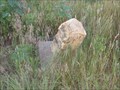
 view gallery view galleryN28 km | BOD Marker near U Rd and 240 Ave in Butterfield Overland Despatch Markers This marker is south of U Rd. and 240 Ave., Trego posted by: Bridgerdigger location: Kansas date approved: 09/09/2007 last visited: 05/01/2010 |
 view gallery view gallery NE28 km NE28 km
| BOD Marker on highway 147 east of Cedar Bluff Dam in Butterfield Overland Despatch Markers This BOD marker is on highway 147 just east of the Cedar Bluff Dam. posted by: Bridgerdigger location: Kansas date approved: 10/24/2007 last visited: 04/30/2010 |
 view gallery view galleryN28.5 km | BOD Marker on 220 Ave. Trego in Butterfield Overland Despatch Markers This BOD Marker is approx. 350 ft. south of U Rd. and 220 Ave. posted by: Bridgerdigger location: Kansas date approved: 09/09/2007 last visited: 05/26/2012 |
 view gallery view galleryN29.3 km | BOD marker on 200 Ave. Trego in Butterfield Overland Despatch Markers The marker is approx. 160 feet north of U Rd. and 200 Ave. posted by: Bridgerdigger location: Kansas date approved: 09/09/2007 last visited: 04/04/2010 |
 view gallery view galleryNE30.7 km | BOD Marker on Trego 370 Ave. in Butterfield Overland Despatch Markers This BOD marker is approx. .45 mile north of X Rd. and 370 Ave. posted by: Bridgerdigger location: Kansas date approved: 09/05/2007 last visited: 10/17/2010 |
 view gallery view gallery SW30.9 km SW30.9 km
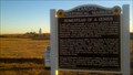
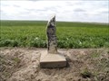
|  Homestead of a genius Homestead of a genius
in Kansas Historical Markers One of the world's most important scientists, George Washington Carver, spent his formative years in Kansas. posted by: azswade location: Kansas date approved: 12/16/2010 last visited: 10/06/2017 |
 view gallery view galleryNW31.2 km | RWD NO 6 - Gove County, KS in Water Towers This standpipe serves this rural area - in Gove County, Kansas. posted by: The Snowdog location: Kansas date approved: 07/17/2024 last visited: never |
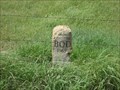
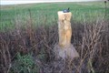
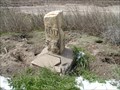
 view gallery view galleryN31.5 km | BOD 8-14-24 in Butterfield Overland Despatch Markers Found marker in good condition. posted by: Kansas Stasher location: Kansas date approved: 04/07/2007 last visited: 05/26/2012 |
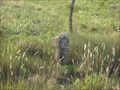
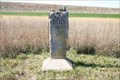
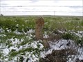
 view gallery view galleryN32.2 km | BOD 6-14-24 in Butterfield Overland Despatch Markers Marker in leaning and has unstable dirt under it. Limestone plaque is dislodged and has a corner broken off. posted by: Kansas Stasher location: Kansas date approved: 04/07/2007 last visited: 05/26/2012 |
 view gallery view galleryNE32.3 km | BOD marker on 390 Ave. in Butterfield Overland Despatch Markers This BOD marker is at the intersection of X Rd. and 390 Ave. posted by: Bridgerdigger location: Kansas date approved: 09/05/2007 last visited: 10/17/2010 |
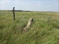
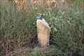
 view gallery view galleryNW33.2 km | BOD 1-14-25 in Butterfield Overland Despatch Markers Found marker in good condition. posted by: Kansas Stasher location: Kansas date approved: 04/07/2007 last visited: 05/26/2012 |
|