 view gallery view gallery SW3.5 km SW3.5 km
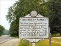
|   The Bryan Family The Bryan Family
in West Virginia Historical Markers The Bryan Family - Cabell Co., WV posted by:  two-bit Joe two-bit Joe location: West Virginia date approved: 03/06/2007 last visited: 03/16/2014 |
 view gallery view gallery E4.8 km E4.8 km
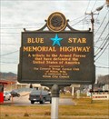
|  U.S. Highway 60 - Milton, WV U.S. Highway 60 - Milton, WV
in Blue Star Memorial Highway Markers This Blue Star Memorial Highway Marker is located in Milton, WV posted by: two-bit Joe location: West Virginia date approved: 03/11/2007 last visited: 11/18/2011 |
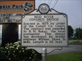 view gallery view galleryE5.1 km | Mud River Covered Bridge in West Virginia Historical Markers A sign telling who designed and built the bridge over Mud River. posted by:  Paintedwarrior Paintedwarrior location: West Virginia date approved: 05/28/2013 last visited: 06/01/2013 |
 view gallery view galleryE5.3 km | Harshbarger Corner in West Virginia Historical Markers Harshbarger Corner Cabell Co., WV posted by: two-bit Joe location: West Virginia date approved: 03/05/2007 last visited: 05/22/2013 |
 view gallery view gallery W5.8 km W5.8 km
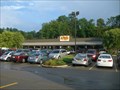
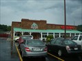
|  Cracker Barrel - Barboursville, WV Cracker Barrel - Barboursville, WV
in Cracker Barrel Restaurants Located off Midland Trl with easy access off I64. posted by: fatcat161 location: West Virginia date approved: 08/05/2009 last visited: 05/27/2015 |
 view gallery view galleryW5.8 km |  Outback Steakhouse - Huntington Outback Steakhouse - Huntington
in Steakhouses Located off Midland Trl with easy access off I64. posted by: fatcat161 location: West Virginia date approved: 08/05/2009 last visited: 05/27/2015 |
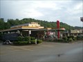 view gallery view galleryW6 km |  Sonic Drive-in - Barboursville, WV Sonic Drive-in - Barboursville, WV
in Sonic Drive In Restaurants Located on Us Route 60 (Midland Trl). posted by: fatcat161 location: West Virginia date approved: 08/05/2009 last visited: 05/27/2015 |
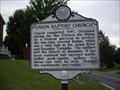 view gallery view galleryE6.6 km | Union Baptist Church in West Virginia Historical Markers A sign telling how the church building was used during the civil war. posted by: Paintedwarrior location: West Virginia date approved: 05/28/2013 last visited: 06/01/2013 |
 view gallery view galleryW8.4 km |  H-Town Geocacher Wintz50 H-Town Geocacher Wintz50
in Geocaching Tour Guides Looking for help in the Ashland-Ironton-Huntington-Barboursville area, look me up and I can guide you around to all the caches. posted by: Wintz50 location: West Virginia date approved: 08/04/2008 last visited: 07/31/2008 |
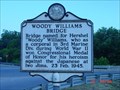 view gallery view galleryW8.7 km | Woody Williams Bridge in West Virginia Historical Markers Woody Williams Bridge Historical Marker posted by: The Finding Irish 4 location: West Virginia date approved: 08/02/2008 last visited: 02/03/2023 |
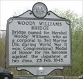 view gallery view galleryW8.7 km |  Woody Williams Bridge - Barboursville WV Woody Williams Bridge - Barboursville WV
in People-Named Places MARKER TEXT-Bridge named for Hershel "Woody" Williams, who as a corporal in 3rd Marine Div. during World War II won Congressional Medal of Honor for his heroism against the Japanese at Iwo Jima, 23 Feb. 1945. posted by: Don.Morfe location: West Virginia date approved: 02/03/2023 last visited: 02/03/2023 |
 view gallery view galleryW9 km |  I got my eye on you . I got my eye on you .
in Web Cameras A 24-hour web cam from the corner of 5th Avenue and 10th Street
in downtown Huntington.w.v. posted by: moondawg20 location: West Virginia date approved: 06/25/2010 last visited: never |
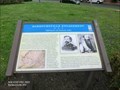
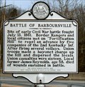 view gallery view galleryW9 km | Battle of Barboursville in West Virginia Historical Markers Battle of Barboursville Cabell Co., WV posted by: two-bit Joe location: West Virginia date approved: 03/04/2007 last visited: 09/02/2013 |
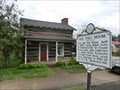 view gallery view galleryW9.2 km |  Old Toll House - Barboursville WV Old Toll House - Barboursville WV
in Bygone Toll Houses This Old Toll House, built in 1837, stood below town of Barboursville on Guyan River bank; tolls collected on James River-Kanawha Turnpike from those using ferry. posted by: Don.Morfe location: West Virginia date approved: 03/14/2023 last visited: 03/09/2023 |
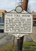 view gallery view galleryW9.2 km | Old Toll House in West Virginia Historical Markers Old Toll House, Cabell Co., WV posted by: two-bit Joe location: West Virginia date approved: 03/05/2007 last visited: 03/09/2023 |
 view gallery view galleryW9.2 km |  Barboursville Engagement-Fighting for the Kanawha Valley - Barboursville WV Barboursville Engagement-Fighting for the Kanawha Valley - Barboursville WV
in U.S. Civil War Sites Confederate Gen. Henry A. Wise’s army occupied the Lower Kanawha Valley in June 1861. Union Gen. George B. McClellan assigned the task of driving them out to Gen. Jacob D. Cox, who massed his troops in Gallipolis, Ohio. posted by: Don.Morfe location: West Virginia date approved: 07/03/2023 last visited: 07/03/2023 |
 view gallery view galleryW9.2 km | Barboursville Engagement-Fighting for the Kanawha Valley - Barboursville WV in Civil War Discovery Trail Sites Confederate Gen. Henry A. Wise’s army occupied the Lower Kanawha Valley in June 1861. Union Gen. George B. McClellan assigned the task of driving them out to Gen. Jacob D. Cox, who massed his troops in Gallipolis, Ohio. posted by: Don.Morfe location: West Virginia date approved: 08/12/2020 last visited: 10/05/2021 |
 view gallery view galleryW9.2 km |  Barboursville Engagement - Barboursville WV Barboursville Engagement - Barboursville WV
in Battlefields Cox planned to cross the Ohio River, occupy Point Pleasant, and push up the Kanawha River to Charleston. He launched a three-prong drive on July 11, and the first clash of consequence occurred here at Barboursville on July 14. posted by: Don.Morfe location: West Virginia date approved: 11/21/2020 last visited: 10/16/2021 |
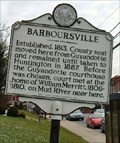 view gallery view galleryW9.3 km | Barboursville in West Virginia Historical Markers Barboursville, WV posted by: two-bit Joe location: West Virginia date approved: 03/04/2007 last visited: 03/09/2023 |
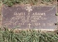 view gallery view galleryW10.1 km |  James F. Adams-Huntington, WV James F. Adams-Huntington, WV
in Medal Of Honor Resting Places Civil War Medal of Honor Recipient for action at Nineveh, VA on November 12, 1864. He is buried in Oaklawn Memorial Park, Huntingtoon, WV. posted by: Don.Morfe location: West Virginia date approved: 06/25/2018 last visited: 12/12/2021 |
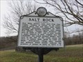 view gallery view gallerySW10.6 km | Salt Rock in West Virginia Historical Markers A brief history of the area. posted by: dukemartin location: West Virginia date approved: 03/16/2021 last visited: never |
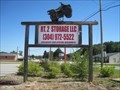 view gallery view gallery NW11.1 km NW11.1 km
|  Elevated ATV - Lesage, WV Elevated ATV - Lesage, WV
in Elevated Everyday Objects An ATV up in the air and in front of Rt.2 Storage LLC in Lesage, Cabell County, West Virginia. posted by: king.hubi location: West Virginia date approved: 09/14/2010 last visited: never |
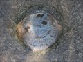 view gallery view galleryNW11.7 km |  HY2183 - W 331 - Lesage, WV HY2183 - W 331 - Lesage, WV
in U.S. Benchmarks A vertical control mark from the National Geodetic Survey (NGS) located along the Ohio River Road (aka Route 2) in Lesage, Cabell County, West Virginia. posted by: king.hubi location: West Virginia date approved: 09/15/2010 last visited: never |
 view gallery view galleryNW12.2 km |  Hillbilly Hot Dogs - Lesage, WV Hillbilly Hot Dogs - Lesage, WV
in Independent Hot Dog Restaurants What can I say..... This is Hillbilly Hotdogs, ONE OF A KIND...
If you pass it buy it will be your loss, stop and see the best FOLKS around.
As they say "The Best Hot Dog Stand in the land!"
posted by: The Finding Irish 4 location: West Virginia date approved: 09/17/2008 last visited: 11/27/2020 |
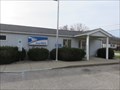 view gallery view gallery S12.6 km S12.6 km
|  Salt Rock, WV 25559 Salt Rock, WV 25559
in U.S. Post Offices Salt Rock, WV 25559 Post Office posted by: dukemartin location: West Virginia date approved: 03/16/2021 last visited: never |
|