 view gallery view gallery NE1.4 km NE1.4 km
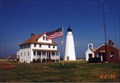
|   Cove Point Lighthouse Cove Point Lighthouse
in Coastal Lighthouses The Cove Point Lighthouse is open to the public during certain times of the year. Click this link below to view the schedule on the Calvert Marine Museum's site. posted by:  redlights redlights location: Maryland date approved: 05/22/2008 last visited: 07/09/2011 |
 view gallery view gallery W3.7 km W3.7 km
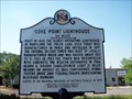
|  Cove Point Lighthouse Cove Point Lighthouse
in Maryland Historical Markers This historical marker sits along Cove Point Road, about 150 yards east of Rte 4. There is a park & ride very nearby so viewing this one is plenty safe. posted by: redlights location: Maryland date approved: 06/18/2008 last visited: 03/22/2009 |
 view gallery view gallery NW4.3 km NW4.3 km
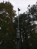
|  ASE Warning Siren - Calvert, MD ASE Warning Siren - Calvert, MD
in Outdoor Warning Sirens An ASE warning siren for the nearby nuclear power plant in Calvert Cliffs State Park. posted by: bluesnote location: Maryland date approved: 11/24/2018 last visited: 11/24/2018 |
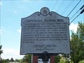
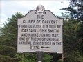 view gallery view galleryNW4.3 km | The CLIFFS of CALVERT in Maryland Historical Markers This historical marker is right at the front gate of Calvert Cliffs State Park. The park itself has lots of great trails that lead down to the cliffs themselves. posted by: redlights location: Maryland date approved: 07/01/2008 last visited: 07/01/2022 |
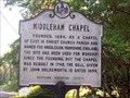 view gallery view galleryNW4.7 km | Middleham Chapel in Maryland Historical Markers This historic marker sits along side of Rte. 765 leading towards Lusby, MD. You can park along the road or pull into the lot nearby. posted by: redlights location: Maryland date approved: 06/18/2008 last visited: 11/19/2013 |
 view gallery view gallery SW6.4 km SW6.4 km
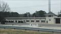
|  Solomons Vol. Rescue Squad & Fire Dept. Solomons Vol. Rescue Squad & Fire Dept.
in Firehouses A fire station in Solomons, Maryland. posted by: bluesnote location: Maryland date approved: 12/20/2021 last visited: never |
 view gallery view gallerySW6.4 km |  Solomons Volunteer Rescue Squad Fire Department Flagpole - Solomons, MD Solomons Volunteer Rescue Squad Fire Department Flagpole - Solomons, MD
in Nautical Flag Poles A nautical flagpole at the Solomons Volunteer Rescue Squad Fire Department in Solomons, Maryland. posted by: bluesnote location: Maryland date approved: 12/28/2021 last visited: never |
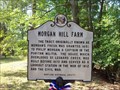 view gallery view galleryNW6.6 km | MORGAN HILL FARM in Maryland Historical Markers This historical marker sits at the junction of Sollers Wharf Road and Wohlgemuth Road in southern Calvert County. posted by: redlights location: Maryland date approved: 07/11/2008 last visited: never |
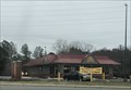
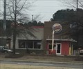 view gallery view gallerySW6.8 km |  Burger King - H. G. Trueman Rd. - Solomons, MD Burger King - H. G. Trueman Rd. - Solomons, MD
in Burger King Restaurants A Burger King in Solomons, Maryland. posted by: bluesnote location: Maryland date approved: 12/22/2021 last visited: never |
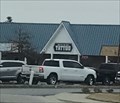
 view gallery view gallerySW6.9 km |  McDonald's - H. G. Trueman Rd. - Solomons, MD McDonald's - H. G. Trueman Rd. - Solomons, MD
in McDonald's Restaurants A McDonald's in Solomons, Maryland. posted by: bluesnote location: Maryland date approved: 12/20/2021 last visited: never |
 view gallery view gallerySW7.1 km | Amphibious Training Base in Maryland Historical Markers Amphibious Training Base. The historical marker is displayed along the side of Dowell Road, just before entering Calvert Marina. posted by: redlights location: Maryland date approved: 06/19/2008 last visited: 07/09/2011 |
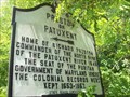 view gallery view galleryNW7.1 km | Preston on Patuxent in Maryland Historical Markers Preston on Patuxent, this historical marker is located on Pardoe Rd, in Calvert County, MD. posted by: redlights location: Maryland date approved: 06/19/2008 last visited: never |
 view gallery view gallerySW7.7 km |  King of the Bay Tattoo - Solomons, MD King of the Bay Tattoo - Solomons, MD
in Tattoo Shops/Parlors A tattoo shop in Solomons, Maryland. posted by: bluesnote location: Maryland date approved: 05/23/2022 last visited: never |
 view gallery view gallerySW7.7 km |  Solomons, Maryland 20688 Solomons, Maryland 20688
in U.S. Post Offices A post office in Solomons, Maryland. posted by: bluesnote location: Maryland date approved: 05/22/2022 last visited: never |
 view gallery view gallerySW7.7 km |  Sawatdee - Solomons, MD Sawatdee - Solomons, MD
in Independent Fish Houses A Thai seafood restaurant in Solomons, Maryland. posted by: bluesnote location: Maryland date approved: 05/21/2022 last visited: never |
 view gallery view gallerySW7.7 km |  Sawatdee - Solomons, MD Sawatdee - Solomons, MD
in Thai Restaurants A Thai seafood restaurant in Solomons, Maryland. posted by: bluesnote location: Maryland date approved: 05/23/2022 last visited: never |
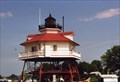 view gallery view gallerySW7.9 km | Drum Point Lighthouse in Coastal Lighthouses The Drum Point Lighthouse is open to the public with paid admission to the Calvert Marine Museum. But the lighthouse can be photographed without having to pay. Click the link below to view the Calvert Marine Museum's site. posted by: redlights location: Maryland date approved: 06/13/2008 last visited: 01/20/2022 |
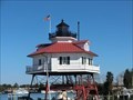 view gallery view gallerySW7.9 km |  Drum Point Lighthouse - Solomons MD Drum Point Lighthouse - Solomons MD
in U.S. National Register of Historic Places The Drum Point Lighthouse is one of four remaining screwpile lighthouses on the Chesapeake Bay. Any lighthouse, and particularly a historic structure, is fast disappearing as navigational equipment due to the modern communications channels. posted by:  Don.Morfe Don.Morfe location: Maryland date approved: 10/05/2022 last visited: 10/04/2022 |
 view gallery view gallerySW7.9 km |  Drum Point Lighthouse - Solomons MD Drum Point Lighthouse - Solomons MD
in Signs of History Drum Point Lighthouse was built in 1883 to mark the northern approach to the Patuxent River. It was originally located due south of Drum Point, 120 yards offshore, on five acres of submerged land conveyed by Maryland to the federal government. posted by: Don.Morfe location: Maryland date approved: 09/15/2020 last visited: 01/20/2022 |
 view gallery view gallerySW7.9 km |  Drum Point Light - Solomons, MD Drum Point Light - Solomons, MD
in Wikipedia Entries Drum Point Light is one of four surviving Chesapeake Bay screw-pile lighthouses. Originally located off Drum Point at the mouth of the Patuxent River, it is now an exhibit at the Calvert Marine Museum. posted by: Don.Morfe location: Maryland date approved: 10/04/2022 last visited: 10/04/2022 |
 view gallery view gallerySW7.9 km |  Menace on the Horizon Star-Spangled Banner National Historical Trail - Solomons MD- Menace on the Horizon Star-Spangled Banner National Historical Trail - Solomons MD-
in War of 1812 Terror reigned along the Patuxent River in 1814. British invaders plundered and burned towns and plantations on both sides of the river. posted by: Don.Morfe location: Maryland date approved: 03/15/2020 last visited: 11/02/2021 |
 view gallery view gallerySW7.9 km | Menace on the Horizon Star-Spangled Banner National Historical Trail - Solomons MD in Signs of History Terror reigned along the Patuxent River in 1814. British invaders plundered and burned towns and plantations on both sides of the river. posted by: Don.Morfe location: Maryland date approved: 08/31/2022 last visited: 08/31/2022 |
 view gallery view gallerySW7.9 km |  Menace on the Horizon - Solomons MD Menace on the Horizon - Solomons MD
in Battlefields The marker is located on the grounds of the Calvert Marine Museum in front of the main exhibition hall, 14200 Solomons Island Road South, Solomons, MD United States 20688. posted by: Don.Morfe location: Maryland date approved: 09/15/2023 last visited: 09/15/2023 |
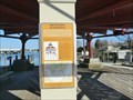
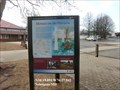
 view gallery view gallerySW7.9 km |  'You Are Here' Maps-Menace on the Horizon - Solomons MD 'You Are Here' Maps-Menace on the Horizon - Solomons MD
in 'You Are Here' Maps 'You Are Here' Map shows that you are on the grounds of the Calvert Marine Museum in front of the main exhibition hall, 14200 Solomons Island Road South, Solomons, MD United States 20688. posted by: Don.Morfe location: Maryland date approved: 09/13/2023 last visited: 09/13/2023 |
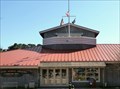 view gallery view gallerySW8 km |  Calvert Marine Museum - Solomons Island MD Calvert Marine Museum - Solomons Island MD
in Maritime Museums The Calvert Marine Museum is a maritime museum located in Solomons, Maryland. The museum has three main themes: regional paleontology, estuarine life of the Patuxent River and Chesapeake Bay, maritime history. posted by: Don.Morfe location: Maryland date approved: 01/19/2022 last visited: 01/20/2022 |
|