 view gallery view gallery N11.3 km N11.3 km
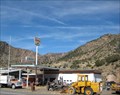
|   Sinclair - Cimarron, CO Sinclair - Cimarron, CO
in Vintage Gas Stations This vintage gas station is located in Cimarron, CO. posted by:  Team Min Dawg Team Min Dawg location: Colorado date approved: 11/26/2008 last visited: 10/08/2011 |
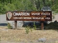 view gallery view galleryN11.6 km | ") Curecanti National Recreation Area - Gunnison, Colorado Curecanti National Recreation Area - Gunnison, Colorado
in National Parks (U.S.) Curecanti National Recreation Area is near Black Canyon of the Gunnison National Park. posted by:  paulspaper paulspaper location: Colorado date approved: 05/05/2008 last visited: 05/11/2023 |
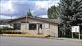
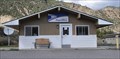 view gallery view galleryN11.7 km |  Cimarron, Colorado 81220 Cimarron, Colorado 81220
in U.S. Post Offices This Post Office is located at 82111 E US Highway 50 in Cimarron, Colorado. posted by: brwhiz location: Colorado date approved: 10/31/2011 last visited: 10/08/2011 |
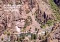
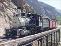 view gallery view galleryN12.9 km |  Locomotive #278 - Gunnison, Colorado Locomotive #278 - Gunnison, Colorado
in Locomotives The Cimarron Canyon Rail Exhibit consists of Locomotive #278, its coal tender, a boxcar, and caboose stand atop the last remaining railroad trestle along the Black Canyon of the Gunnison route. posted by: paulspaper location: Colorado date approved: 04/25/2008 last visited: 09/11/2010 |
 view gallery view gallery S22.7 km S22.7 km
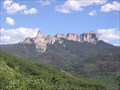
|  Courthouse Mountain Courthouse Mountain
in Mountain Summits A 4 mile rountrip hike up 1,790 feet, which requires some easy rock scrambling. The trail is located mostly inside the Uncompahgre Wilderness, so please follow wilderness rules. posted by: krazykatzen location: Colorado date approved: 08/04/2009 last visited: never |
 view gallery view gallery W22.7 km W22.7 km
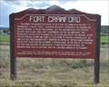
|  Fort Crawford ~ Montrose County, Colorado Fort Crawford ~ Montrose County, Colorado
in Colorado Historical Markers This Colorado Historical Marker is located on the southeast side of US Highway 550 about 7 miles south of Montrose, Colorado. posted by: brwhiz location: Colorado date approved: 02/14/2013 last visited: 01/24/2015 |
 view gallery view gallery NE24.3 km NE24.3 km
|  Curecanti National Recreation Area - Gunnison CO Curecanti National Recreation Area - Gunnison CO
in Official Local Tourism Attractions Curecanti National Recreation Area is a National Park Service unit located on the Gunnison River in western Colorado. It was established in 1965. posted by: Don.Morfe location: Colorado date approved: 03/13/2022 last visited: 05/11/2023 |
 view gallery view galleryNE24.3 km |  Curecanti National Recreation Area - Gunnison CO Curecanti National Recreation Area - Gunnison CO
in National Parks of the World Curecanti National Recreation Area is a National Park Service unit located on the Gunnison River in western Colorado. It was established in 1965. posted by: Don.Morfe location: Colorado date approved: 03/12/2022 last visited: 05/11/2023 |
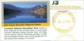 view gallery view galleryNE24.3 km |  Curecanti National Recreation Area - Gunnison CO Curecanti National Recreation Area - Gunnison CO
in NPS Passport Cancellation Stations Curecanti National Recreation Area is a National Park Service unit located on the Gunnison River in western Colorado. It was established in 1965. posted by: Don.Morfe location: Colorado date approved: 03/25/2022 last visited: 05/11/2023 |
 view gallery view galleryNE24.3 km |  Curecanti National Recreation Area - Gunnison CO Curecanti National Recreation Area - Gunnison CO
in Wikipedia Entries Curecanti National Recreation Area is a National Park Service unit located on the Gunnison River in western Colorado. It was established in 1965. posted by: Don.Morfe location: Colorado date approved: 03/12/2022 last visited: 03/13/2022 |
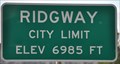
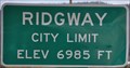 view gallery view gallery SW25.3 km SW25.3 km
|  Ridgway, Colorado (Northern Approach) ~ Elevation 6985 Feet Ridgway, Colorado (Northern Approach) ~ Elevation 6985 Feet
in Elevation Signs This Elevation Sign is located on the northwest side of US Highway 550 at the northern town limit of Ridgeway, Colorado. posted by: brwhiz location: Colorado date approved: 02/12/2013 last visited: never |
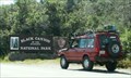
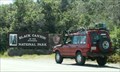
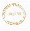 view gallery view gallery NW26.4 km NW26.4 km
| Black Canyon of the Gunnison - Montrose, CO in NPS Passport Cancellation Stations This Passport Cancellation Station can be found in the Visitor Center for the Black Canyon of the Gunnison along the South Rim. posted by: cldisme location: Colorado date approved: 08/19/2010 last visited: 05/11/2023 |
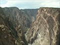
 view gallery view galleryNW26.4 km | Black Canyon of the Gunnison National Park, Montrose, CO in Wikipedia Entries Black Canyon of the Gunnison National Park is considered the Grand Canyon of Colorado, just six miles east of Montrose. posted by: 94RedRover location: Colorado date approved: 05/24/2008 last visited: 07/07/2023 |
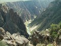 view gallery view galleryNW26.4 km | Gunnison River, Colorado in Wikipedia Entries The Gunnison River is the fifth largest tributary of the Colorado River, approximately 180 mi (290 km) long, ranging in width from 100 to 1000 feet and 3 to 50 feet in depth, in the U.S. state of Colorado. posted by: 94RedRover location: Colorado date approved: 05/24/2008 last visited: 07/07/2023 |
 view gallery view galleryNW26.4 km | Black Canyon of the Gunnison, Montrose, CO in Official Local Tourism Attractions Just six miles from Montrose, Colorado, the Black Canyon of the Gunnison is the "Grand Canyon" of Colorado. posted by: 94RedRover location: Colorado date approved: 03/24/2008 last visited: 07/07/2023 |
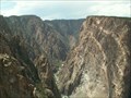 view gallery view galleryNW26.4 km |  Black Canyon of the Gunnison, Montrose, CO Black Canyon of the Gunnison, Montrose, CO
in Places of Geologic Significance Just six miles from Montrose, Colorado, the Black Canyon of the Gunnison is the "Grand Canyon" of Colorado. posted by: 94RedRover location: Colorado date approved: 03/05/2008 last visited: 07/07/2023 |
 view gallery view galleryNW26.4 km | Black Canyon of the Gunnison National Park in National Parks (U.S.) Black Canyon of the Gunnison National Park is considered the Grand Canyon of Colorado.
posted by: 94RedRover location: Colorado date approved: 05/05/2008 last visited: 07/07/2023 |
 view gallery view galleryNW26.4 km | Black Canyon of the Gunnison NP in National Parks of the World Black Canyon of the Gunnison is considered the Grand Canyon of Colorado. posted by: 94RedRover location: Colorado date approved: 01/27/2008 last visited: 07/07/2023 |
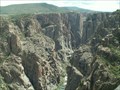 view gallery view galleryNW26.4 km |  Black Canyon of the Gunnison - Montrose, CO Black Canyon of the Gunnison - Montrose, CO
in American Guide Series The Black Canyon of the Gunnison National Monument was established by President Herbert Hoover on March 2, 1933, It includes 10 miles of picturesque roads throuh Colorado's deepest gorge. posted by: 94RedRover location: Colorado date approved: 02/01/2009 last visited: 07/07/2023 |
 view gallery view galleryNW26.4 km |  Black Canyon of the Gunnison National Park - Montrose CO Black Canyon of the Gunnison National Park - Montrose CO
in Ranger Stations The Ranger Station is in the Visitor Center of the National Park. This is where you may obtain a NPS Cancellation Stamp. posted by: Don.Morfe location: Colorado date approved: 03/14/2022 last visited: 05/11/2023 |
 view gallery view galleryNW26.4 km |  West Elk Loop - Black Canyon of the Gunnison National Park, CO West Elk Loop - Black Canyon of the Gunnison National Park, CO
in National Scenic Byways The West Elk Loop travels through the Crystal River Valley, whose well-watered reaches made it a favorite among both Native American and pioneer settlers. posted by: 94RedRover location: Colorado date approved: 01/31/2009 last visited: 07/07/2023 |
 view gallery view galleryNW26.4 km |  Black Canyon of the Gunnison National Park, Colorado Black Canyon of the Gunnison National Park, Colorado
in 1000 Places to See Before You Die The Black Canyon of the Gunnison National Park is considered the Grand Canyon of Colorado, just six miles east of Montrose. posted by: 94RedRover location: Colorado date approved: 02/02/2010 last visited: 07/07/2023 |
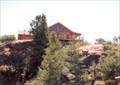
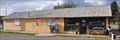 view gallery view gallerySW26.6 km |  Ridgway Chamber of Commerce Visitor Center Ridgway Chamber of Commerce Visitor Center
in Tourist Information Centers - Visitor Centers This Tourist Information Center, operated by the Ridgeway Chamber of Commerce, is located at 150 Racecourse Road in Ridgway, Colorado. posted by: brwhiz location: Colorado date approved: 02/13/2013 last visited: 08/16/2014 |
 view gallery view gallerySW26.6 km | Ridgway, Colorado (Southern Approach) ~ Elevation 6985 Feet in Elevation Signs This Elevation Sign is located on the east side of US Highway 550 at the southern town limit of Ridgeway, Colorado. posted by: brwhiz location: Colorado date approved: 02/12/2013 last visited: never |
 view gallery view gallerySW26.7 km | Ridgway, Colorado 81432 in U.S. Post Offices This Post Office is located at 485 Clinton Street in Ridgway, Colorado. posted by: brwhiz location: Colorado date approved: 10/31/2011 last visited: never |
|