 view gallery view gallery N5.3 km N5.3 km
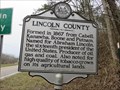
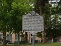
|   Lincoln County / Putnam County Lincoln County / Putnam County
in West Virginia Historical Markers A two sided sign describing when the counties were formed and what counties they were formed from. posted by:  Paintedwarrior Paintedwarrior location: West Virginia date approved: 02/21/2017 last visited: 02/21/2017 |
 view gallery view gallery W7.4 km W7.4 km
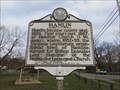
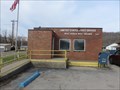
|  Hamlin, WV 25523 Hamlin, WV 25523
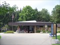
in U.S. Post Offices Hamlin, WV 25523 Post Office posted by: dukemartin location: West Virginia date approved: 03/16/2021 last visited: never |
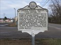
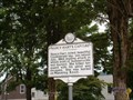
 view gallery view galleryW7.9 km | Hamlin in West Virginia Historical Markers A short history of Hamin, WV posted by: dukemartin location: West Virginia date approved: 03/16/2021 last visited: never |
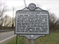 view gallery view galleryW7.9 km | Skirmish At The Curry Farm in West Virginia Historical Markers A short description of the brief skirmish here. posted by: dukemartin location: West Virginia date approved: 03/16/2021 last visited: never |
 view gallery view galleryW8.9 km | Lincoln County Primary Care Center, Inc. in West Virginia Historical Markers First federally designated rural health care center. posted by: dukemartin location: West Virginia date approved: 03/16/2021 last visited: never |
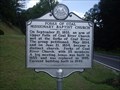
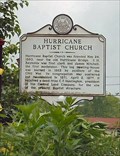 view gallery view galleryN13.5 km | Hurricane Baptist Church/Hurricane Bridge Skirmish in West Virginia Historical Markers Hurricane Baptist Church, Putnam Co., WV posted by:  two-bit Joe two-bit Joe location: West Virginia date approved: 04/14/2007 last visited: 02/21/2017 |
 view gallery view gallery E14.8 km E14.8 km
| Summersville in West Virginia Historical Markers Summersville was established in 1820 posted by: two-bit Joe location: West Virginia date approved: 11/22/2007 last visited: 09/01/2004 |
 view gallery view galleryE14.8 km | Nancy Hart's Capture in West Virginia Historical Markers Nancy Hart, noted, beautiful Confederate spy, was seized July, 1862 posted by: two-bit Joe location: West Virginia date approved: 11/22/2007 last visited: 09/14/2013 |
 view gallery view galleryW15.3 km | West Hamlin, WV 25571 in U.S. Post Offices West Hamlin, WV 25571 Post Office posted by: dukemartin location: West Virginia date approved: 03/16/2021 last visited: never |
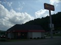 view gallery view galleryW15.8 km |  Hardee's - West Hamlin, WV Hardee's - West Hamlin, WV
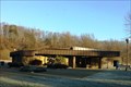
in Carl's Jr./Hardee's Restaurants Located on Hwy 10 (Lincoln Plz). posted by: fatcat161 location: West Virginia date approved: 08/05/2009 last visited: never |
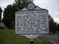 view gallery view gallery NW16.7 km NW16.7 km
| Union Baptist Church in West Virginia Historical Markers A sign telling how the church building was used during the civil war. posted by: Paintedwarrior location: West Virginia date approved: 05/28/2013 last visited: 06/01/2013 |
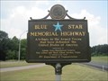 view gallery view galleryN17.4 km |  Interstate 64, Rest Area (eastbound) - Hurricane, WV Interstate 64, Rest Area (eastbound) - Hurricane, WV
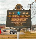
in Blue Star Memorial Highway Markers Blue Star Memorial Highway Marker located along the Interstate 64 just after exit 34 at the rest area (eastbound) in Hurricane, West Virginia. posted by: king.hubi location: West Virginia date approved: 09/19/2010 last visited: 06/03/2018 |
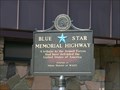 view gallery view galleryN17.4 km | Interstate 64, Hurricane, WV in Blue Star Memorial Highway Markers Located at the Westbound Rest Area on Interstate 64, Exit 35 posted by: debbado location: West Virginia date approved: 08/23/2009 last visited: 06/03/2018 |
 view gallery view galleryN17.4 km |  I-64 Rest Area - Exit 35 - Hurricane, WV I-64 Rest Area - Exit 35 - Hurricane, WV
in Highway Rest Areas This rest area is going Eastbound on I-64, just before the Hurricane exit. posted by: debbado location: West Virginia date approved: 08/23/2009 last visited: 01/29/2021 |
 view gallery view galleryN17.4 km | Hurricane Rest Area WB - I-64 Westbound - Hurricane, WV in Highway Rest Areas This rest area is one of a pair located on Interstate 64 at Mile 35 near Hurricane, West Virginia. This one in particular, is located in the westbound direction of travel. posted by: outdoorboy34 location: West Virginia date approved: 01/26/2017 last visited: 06/03/2018 |
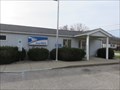 view gallery view galleryW17.9 km | Salt Rock, WV 25559 in U.S. Post Offices Salt Rock, WV 25559 Post Office posted by: dukemartin location: West Virginia date approved: 03/16/2021 last visited: never |
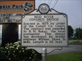 view gallery view galleryNW17.9 km | Mud River Covered Bridge in West Virginia Historical Markers A sign telling who designed and built the bridge over Mud River. posted by: Paintedwarrior location: West Virginia date approved: 05/28/2013 last visited: 06/01/2013 |
 view gallery view galleryE18.3 km | Forks of Coal Missionary Baptist Church in West Virginia Historical Markers A sign telling us how the church here broke away and became a distinct church. posted by: Paintedwarrior location: West Virginia date approved: 09/09/2013 last visited: 09/14/2013 |
 view gallery view galleryNW18.5 km | Harshbarger Corner in West Virginia Historical Markers Harshbarger Corner Cabell Co., WV posted by: two-bit Joe location: West Virginia date approved: 03/05/2007 last visited: 05/22/2013 |
 view gallery view gallery NE18.7 km NE18.7 km
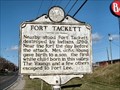
| Fort Tackett in West Virginia Historical Markers Fort Tackett, Kanawha Co., WV posted by: two-bit Joe location: West Virginia date approved: 02/27/2007 last visited: 05/20/2013 |
 view gallery view galleryNW18.7 km | U.S. Highway 60 - Milton, WV in Blue Star Memorial Highway Markers This Blue Star Memorial Highway Marker is located in Milton, WV posted by: two-bit Joe location: West Virginia date approved: 03/11/2007 last visited: 11/18/2011 |
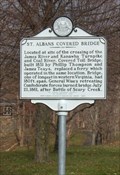 view gallery view galleryNE18.8 km | St. Albans Covered Bridge in West Virginia Historical Markers Located at site of the crossing of the James River and Kanawha Turnpike and Coal River. Covered Toll Bridge, built 1831 by Phillip Thompson and James Teays, replaced a ferry which operated in the same location. Bridge, one of longest in western Virginia, had 180 ft. span. General Wise's retreating Confederate forces burned bridge July 21, 1861, after Battle of Scary Creek.
Location: Along roadway in front of McKinley Jr. High, Kanawha Terrace, St. Albans
posted by: two-bit Joe location: West Virginia date approved: 08/17/2006 last visited: 02/18/2017 |
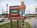 view gallery view galleryN19.2 km |  Smokey Bear - Teays Valley, West Virginia Smokey Bear - Teays Valley, West Virginia
in Smokey Bear Sign Sightings Another found Smokey Bear sign. posted by: gvsu4msu location: West Virginia date approved: 07/15/2008 last visited: 03/04/2011 |
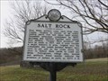 view gallery view galleryW20 km | Salt Rock in West Virginia Historical Markers A brief history of the area. posted by: dukemartin location: West Virginia date approved: 03/16/2021 last visited: never |
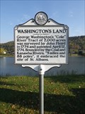 view gallery view galleryNE20 km | Washington's Land in West Virginia Historical Markers A marker noting the land boundaries of a land patent issued to President George Washington. Located on the southern boundary of his estate the marker is found on the bank of the Kanawha River. posted by: PersonsMD location: West Virginia date approved: 05/29/2013 last visited: 02/04/2017 |
|