 view gallery view gallery NE7.2 km NE7.2 km
|   Summersville Summersville
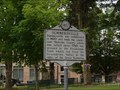
in West Virginia Historical Markers Summersville was established in 1820 posted by:  two-bit Joe two-bit Joe location: West Virginia date approved: 11/22/2007 last visited: 09/01/2004 |
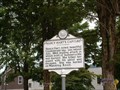 view gallery view galleryNE7.2 km | Nancy Hart's Capture in West Virginia Historical Markers Nancy Hart, noted, beautiful Confederate spy, was seized July, 1862 posted by: two-bit Joe location: West Virginia date approved: 11/22/2007 last visited: 09/14/2013 |
 view gallery view gallery E10.8 km E10.8 km
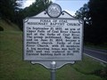
| Forks of Coal Missionary Baptist Church in West Virginia Historical Markers A sign telling us how the church here broke away and became a distinct church. posted by:  Paintedwarrior Paintedwarrior location: West Virginia date approved: 09/09/2013 last visited: 09/14/2013 |
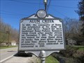 view gallery view galleryE12.7 km | Alum Creek in West Virginia Historical Markers A quick history how the town was named. posted by: dukemartin location: West Virginia date approved: 04/09/2018 last visited: 04/09/2018 |
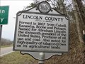 view gallery view gallery NW13.8 km NW13.8 km
| Lincoln County / Putnam County in West Virginia Historical Markers A two sided sign describing when the counties were formed and what counties they were formed from. posted by: Paintedwarrior location: West Virginia date approved: 02/21/2017 last visited: 02/21/2017 |
 view gallery view gallery W15.6 km W15.6 km
|  Hamlin, WV 25523 Hamlin, WV 25523
in U.S. Post Offices Hamlin, WV 25523 Post Office posted by: dukemartin location: West Virginia date approved: 03/16/2021 last visited: never |
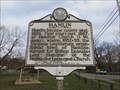 view gallery view galleryW16.1 km | Hamlin in West Virginia Historical Markers A short history of Hamin, WV posted by: dukemartin location: West Virginia date approved: 03/16/2021 last visited: never |
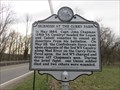 view gallery view galleryW16.3 km | Skirmish At The Curry Farm in West Virginia Historical Markers A short description of the brief skirmish here. posted by: dukemartin location: West Virginia date approved: 03/16/2021 last visited: never |
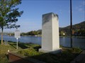
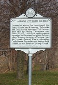 view gallery view galleryNE16.7 km | St. Albans Covered Bridge in West Virginia Historical Markers Located at site of the crossing of the James River and Kanawha Turnpike and Coal River. Covered Toll Bridge, built 1831 by Phillip Thompson and James Teays, replaced a ferry which operated in the same location. Bridge, one of longest in western Virginia, had 180 ft. span. General Wise's retreating Confederate forces burned bridge July 21, 1861, after Battle of Scary Creek.
Location: Along roadway in front of McKinley Jr. High, Kanawha Terrace, St. Albans
posted by: two-bit Joe location: West Virginia date approved: 08/17/2006 last visited: 02/18/2017 |
 view gallery view galleryW17.2 km | Lincoln County Primary Care Center, Inc. in West Virginia Historical Markers First federally designated rural health care center. posted by: dukemartin location: West Virginia date approved: 03/16/2021 last visited: never |
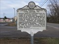
 view gallery view galleryNE17.4 km | Bangor Cemetery in West Virginia Historical Markers Bangor Cemetery located in St. Albans posted by: two-bit Joe location: West Virginia date approved: 01/09/2009 last visited: 02/18/2017 |
 NE17.4 km |  Husson's Pizza St. Albans Husson's Pizza St. Albans
in Wi-Fi Hotspots Surf the net while you wait for your pizza! posted by: Man In The Wild location: West Virginia date approved: 09/15/2005 last visited: never |
 view gallery view gallery N17.4 km N17.4 km
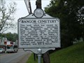
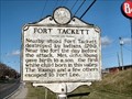
| Fort Tackett in West Virginia Historical Markers Fort Tackett, Kanawha Co., WV posted by: two-bit Joe location: West Virginia date approved: 02/27/2007 last visited: 05/20/2013 |
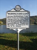 view gallery view galleryNE17.5 km | Washington's Land in West Virginia Historical Markers A marker noting the land boundaries of a land patent issued to President George Washington. Located on the southern boundary of his estate the marker is found on the bank of the Kanawha River. posted by: PersonsMD location: West Virginia date approved: 05/29/2013 last visited: 02/04/2017 |
 view gallery view galleryNE17.5 km |  American Creed War Memorial – St. Albans, West Virginia American Creed War Memorial – St. Albans, West Virginia
in Non-Specific Veteran Memorials This memorial dedicated to the people who have defended our Nation's Freedom, is located on land once granted to and owned by President George Washington at St. Albans, West Virginia. posted by: PersonsMD location: West Virginia date approved: 06/01/2013 last visited: 10/17/2012 |
 view gallery view galleryNE17.5 km |  St. Albans Roadside Park - St. Albans, West Virginia St. Albans Roadside Park - St. Albans, West Virginia
in Public Playgrounds A quiet roadside playground located in the St. Albans Roadside Park set on the flat banks of the Kanawha River on land once owned by President George Washington. Offers old school swings and great views of the river. posted by: PersonsMD location: West Virginia date approved: 05/30/2013 last visited: 10/17/2012 |
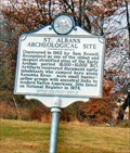 view gallery view galleryNE18 km | St. Albans Archeological Site in West Virginia Historical Markers Archeological Site. Located on US 60 West St. Albans posted by: two-bit Joe location: West Virginia date approved: 08/28/2006 last visited: 02/04/2017 |
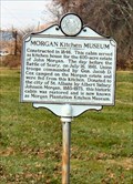 view gallery view galleryNE18.2 km | Morgan Kitchen Museum in West Virginia Historical Markers Morgan Kitchen Museum, located US 60 West(MacCorkle Avenue), 1.8 miles east of Sattes Bridge, St Albans. posted by: two-bit Joe location: West Virginia date approved: 08/25/2006 last visited: 08/10/2013 |
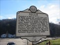
 view gallery view galleryNE18.8 km | Washington's Land in West Virginia Historical Markers George Washington's "Cole" River Tract of 2,000 acres was surveyed by John Floyd in 1774 and patented April 12, 1774. Bounded by the Coal and Kanawha Rivers, "5 miles and 88 poles", it embraced the site of St. Albans posted by: two-bit Joe location: West Virginia date approved: 08/17/2006 last visited: 02/04/2017 |
E19.5 km | Panera Bread Southridge in Wi-Fi Hotspots Free Internet while you eat. posted by: Man In The Wild location: West Virginia date approved: 09/11/2005 last visited: 04/10/2011 |
 view gallery view gallery SE19.6 km SE19.6 km
| Nellis / Armco Coal in West Virginia Historical Markers A two sided sign telling us when Nellis was founded that Armco coal company acquired Nellis coal company. posted by: dukemartin location: West Virginia date approved: 12/21/2018 last visited: never |
 view gallery view galleryN19.6 km | Kanawha County/Putnam County in West Virginia Historical Markers Kanawha County/Putnam County Line posted by: two-bit Joe location: West Virginia date approved: 02/27/2007 last visited: 05/20/2013 |
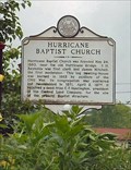 view gallery view galleryNW19.8 km | Hurricane Baptist Church/Hurricane Bridge Skirmish in West Virginia Historical Markers Hurricane Baptist Church, Putnam Co., WV posted by: two-bit Joe location: West Virginia date approved: 04/14/2007 last visited: 02/21/2017 |
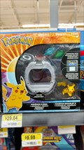 view gallery view galleryE20 km |  Pikachu at Walmart Supercenter in Charlston, WV. Pikachu at Walmart Supercenter in Charlston, WV.
in Pikachu Sightings I saw Pikachu at the Walmart Supercenter in Charlston, WV. posted by: Opie_OpenCacher location: West Virginia date approved: 01/30/2017 last visited: 01/29/2017 |
 view gallery view galleryNE20.1 km | Dunbar, West Virginia - 25064 in U.S. Post Offices Dunbar Post Office is located in the City of Dunbar, West Virginia. posted by: deano1943 location: West Virginia date approved: 07/09/2010 last visited: 11/18/2011 |
|