 view gallery view gallery E26.2 km E26.2 km
|   Fort Larned National Historic Site - Larned, KS Fort Larned National Historic Site - Larned, KS
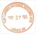
in NPS Passport Cancellation Stations Fort Larned is a well-preserved fort on the Santa Fe Trail shares a tumultuous history of the Indian Wars era. posted by:  Don.Morfe Don.Morfe location: Kansas date approved: 02/14/2020 last visited: 10/10/2021 |
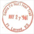 view gallery view galleryE26.2 km | Santa Fe National Historic Trail-Fort Larned KS - Larned, KS in NPS Passport Cancellation Stations The Great Prairie Highway
You can almost hear the whoops and cries of "All's set!" as trail hands hitched their oxen to freight wagons carrying cargo between western Missouri and Santa Fe, New Mexico. posted by: Don.Morfe location: Kansas date approved: 02/25/2020 last visited: 10/10/2021 |
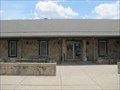
 view gallery view galleryE26.2 km | ") Fort Larned National Historic Site Fort Larned National Historic Site
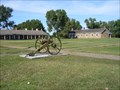
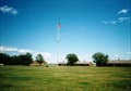
in National Parks (U.S.) Fort Larned National Historic Site, located just west of Larned, Kansas, preserves Fort Larned, which was established in 1859 as a base of military operations against hostile Indians of the Central Plains, to protect traffic along the Santa Fe Trail posted by: leadhiker location: Kansas date approved: 01/25/2010 last visited: 05/07/2022 |
 view gallery view galleryE26.2 km |  Fort Larned National Historic Site - Larned KS Fort Larned National Historic Site - Larned KS
in National Parks of the World Fort Larned National Historic Site preserves Fort Larned which operated from 1859 to 1878. It is approximately 5.5 miles (8.9 km) west of Larned, Kansas, United States. posted by: Don.Morfe location: Kansas date approved: 05/13/2022 last visited: 05/07/2022 |
 view gallery view galleryE26.2 km |  Fort Larned National Historic Site - Larned KS Fort Larned National Historic Site - Larned KS
in Official Local Tourism Attractions Fort Larned National Historic Site preserves Fort Larned which operated from 1859 to 1878. It is approximately 5.5 miles (8.9 km) west of Larned, Kansas, United States. posted by: Don.Morfe location: Kansas date approved: 05/07/2022 last visited: 05/07/2022 |
 view gallery view galleryE26.2 km |  Fort Larned National Historic Site - Larned KS Fort Larned National Historic Site - Larned KS
in Wikipedia Entries Fort Larned National Historic Site preserves Fort Larned which operated from 1859 to 1878. It is approximately 5.5 miles (8.9 km) west of Larned, Kansas, United States. posted by: Don.Morfe location: Kansas date approved: 05/07/2022 last visited: 05/07/2022 |
 view gallery view galleryE26.2 km |  Fort Larned National Historic Site - Larned KS Fort Larned National Historic Site - Larned KS
in Satellite Imagery Oddities Fort Larned National Historic Site preserves Fort Larned which operated from 1859 to 1878. It is approximately 5.5 miles (8.9 km) west of Larned, Kansas, United States. posted by: Don.Morfe location: Kansas date approved: 05/07/2022 last visited: 05/07/2022 |
 view gallery view gallery SE28.6 km SE28.6 km
|  Santa Fe Trail - Garfield, Kansas Santa Fe Trail - Garfield, Kansas
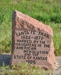
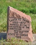
in Wagon Roads and Trails Stone trail monument in Garfield, Kansas. posted by:  BruceS BruceS location: Kansas date approved: 06/07/2012 last visited: 04/06/2017 |
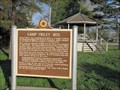 view gallery view gallerySE28.6 km |  Camp Criley 1872 - Garfield, Kansas Camp Criley 1872 - Garfield, Kansas
in Kansas Historical Markers Marker giving history of town of Garfield which was originally known as Camp Criley. posted by: BruceS location: Kansas date approved: 06/18/2012 last visited: 04/06/2017 |
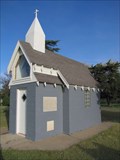 view gallery view gallerySE28.8 km |  Garfield Memorial Wayside Chapel - Garfield, Kansas Garfield Memorial Wayside Chapel - Garfield, Kansas
in Waychapels Wayside chapel in a small park on the east side of Garfield, Kansas. posted by: BruceS location: Kansas date approved: 06/08/2012 last visited: 04/06/2017 |
 view gallery view gallerySE28.8 km | Garfield Memorial Wayside Chapel - Garfield, Kansas in Kansas Historical Markers Marker for wayside chapel in small park on east side of Garfield, Kansas. posted by: BruceS location: Kansas date approved: 06/18/2012 last visited: 04/06/2017 |
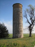 view gallery view gallerySE28.8 km |  Downey Memorial Park Silo - Garfield, Kansas Downey Memorial Park Silo - Garfield, Kansas
in Solitary Silos Silo on east side of Garfield, Kansas. posted by: BruceS location: Kansas date approved: 06/07/2012 last visited: 04/06/2017 |
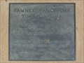 view gallery view galleryE32.8 km |  Pawnee Panorama Time Capsule - Larned, KS Pawnee Panorama Time Capsule - Larned, KS
in Time Capsules Time capsule in the courtyard of the Santa Fe Trail Center in Larned, Kansas posted by: linkys location: Kansas date approved: 06/10/2012 last visited: 03/03/2020 |
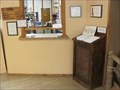 view gallery view galleryE32.8 km |  Santa Fe Trail Center - Larned, KS Santa Fe Trail Center - Larned, KS
in Guest Books Guest book in the Santa Fe Trail Center west of Larned, Kansas. posted by: linkys location: Kansas date approved: 06/12/2012 last visited: never |
 view gallery view galleryE32.8 km |  Santa Fe Trail Center - Larned, KS Santa Fe Trail Center - Larned, KS
in History Museums The Santa Fe Trail Center concentrates on the civilian history of the Santa Fe Trail posted by: linkys location: Kansas date approved: 06/09/2012 last visited: never |
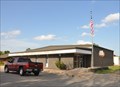 view gallery view gallery S34.3 km S34.3 km
|  Kinsley, Kansas 67547 Kinsley, Kansas 67547
in U.S. Post Offices This Post Office is located at 717 Marsh Avenue in Kinsley, Kansas. posted by:  brwhiz brwhiz location: Kansas date approved: 09/02/2012 last visited: never |
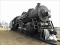 view gallery view galleryS34.4 km |  AT&SF #3424 - Kinsley KS AT&SF #3424 - Kinsley KS
in Locomotives This steam locomotive is a 3400 Class, Pacific type (4-6-2). It is in a small park in Kinsley, Kansas, where US Hwy 50 and US Hwy 56 join or split, depending on which way you're going. posted by: PeterNoG location: Kansas date approved: 02/27/2011 last visited: 12/27/2019 |
 view gallery view galleryS34.4 km |  Midway USA - Kinsley KS Midway USA - Kinsley KS
in Roadside Attractions This roadside attraction is the sign that proclaim that Kinsley, Kansas is "Midway U.S.A.". The distance to New York or to San Francisco is 1561 miles. posted by: PeterNoG location: Kansas date approved: 02/26/2011 last visited: 12/27/2019 |
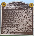 view gallery view galleryS34.9 km | The Battle of Coon Creek in Kansas Historical Markers This Kansas Historical Marker, that replaced an earlier version in 2012, is located on the south side of US Highway 50 about 2 miles east of Kinsley, Kansas. posted by: brwhiz location: Kansas date approved: 02/06/2013 last visited: never |
 view gallery view galleryS34.9 km |  The Battle of Coon Creek The Battle of Coon Creek
in Battlefields This Kansas Historical Marker about the Battle of Coon Creek is located on the south side of US Highway 50 about 2 miles east of Kinsley, Kansas. posted by: brwhiz location: Kansas date approved: 02/05/2013 last visited: 08/22/2015 |
 view gallery view galleryS35.4 km | Santa Fe Trail at Kinsley, Kansas in Wagon Roads and Trails This engraved stone marker for the Santa Fe Trail is located in a turnout on the south side of US Highway 50/56 west of Kinsley, Kansas. posted by: brwhiz location: Kansas date approved: 02/22/2013 last visited: never |
 view gallery view galleryS35.4 km | Santa Fe Trail in Kansas Historical Markers This engraved stone marker for the Santa Fe Trail is located in a turnout on the south side of US Highway 50/56 west of Kinsley, Kansas. posted by: brwhiz location: Kansas date approved: 02/06/2013 last visited: never |
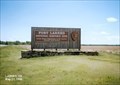
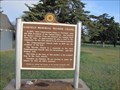
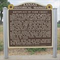 view gallery view galleryE35.4 km | Birthplace of Farm Credit - Larned, KS in Kansas Historical Markers Located in front of a farm a few miles southwest of Larned on US-56. posted by: linkys location: Kansas date approved: 07/01/2012 last visited: never |
 view gallery view gallery NE35.6 km NE35.6 km
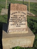
|  Unknown County Farm Cemetery - Rush Center, KS Unknown County Farm Cemetery - Rush Center, KS
in Worldwide Cemeteries This small farm cemetery is northeast of Rush Center, Kansas. posted by: The Snowdog location: Kansas date approved: 07/13/2024 last visited: 07/13/2024 |
 view gallery view galleryNE35.6 km |  Unknown County Farm Cemetery - Rush Center, KS Unknown County Farm Cemetery - Rush Center, KS
in Abandoned Cemeteries This neglected farm cemetery is northeast of Rush Center, Kansas. posted by: The Snowdog location: Kansas date approved: 07/14/2024 last visited: never |
|