 view gallery view gallery NW5.1 km NW5.1 km
|   Seaberry Arms Osborne Seaberry Arms Osborne
in West Virginia Historical Markers A sign giving us a short history of the life of Seaberry. posted by:  dukemartin dukemartin location: West Virginia date approved: 04/09/2018 last visited: 04/09/2018 |
 view gallery view galleryNW6.1 km |  Dixie, WV. 25059 Dixie, WV. 25059
in U.S. Post Offices Dixie WV Post Office posted by: dukemartin location: West Virginia date approved: 08/08/2012 last visited: never |
 view gallery view gallery SW6.6 km SW6.6 km
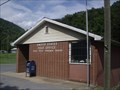
| Gauley Bridge, WV. 25085 in U.S. Post Offices Gauley Bridge WV Post Office posted by: dukemartin location: West Virginia date approved: 08/11/2012 last visited: never |
 view gallery view gallerySW7.2 km |  Battles For The Bridges-Gauley Bridge - A Town in Between - Gauley Bridge Battles For The Bridges-Gauley Bridge - A Town in Between - Gauley Bridge
in U.S. Civil War Sites Marker is in Gauley Bridge, West Virginia, in Fayette County. Marker is at the intersection of Midland Trail (U.S. 60) and Taylor Hill Road, Gauley Bridge WV 25085 posted by:  Don.Morfe Don.Morfe location: West Virginia date approved: 07/07/2023 last visited: 07/07/2023 |
 view gallery view gallerySW7.2 km | Battles For The Bridges-Gauley Bridge - A Town in Between - Gauley Bridge WV in Civil War Discovery Trail Sites Both Confederate and Union forces considered the wooden covered bridge here strategically important because the James River and Kanawha Turnpike linked the Ohio River with the James River. posted by: Don.Morfe location: West Virginia date approved: 08/22/2020 last visited: 10/04/2021 |
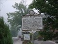
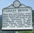 view gallery view gallerySW7.2 km | Gauley Bridge in West Virginia Historical Markers A historical marker located beside U.S. Route 60 near the confluence of the Gauley and New Rivers in Gauley Bridge, West Virginia. posted by: Cache Sleuth location: West Virginia date approved: 05/20/2009 last visited: 09/29/2011 |
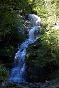 view gallery view gallerySW7.2 km |  Cathedral Falls Cathedral Falls
in Waterfalls Easy to visit falls right next to hwy US 60. posted by: wardnkathy location: West Virginia date approved: 10/09/2011 last visited: 10/19/2013 |
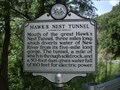 view gallery view gallerySW7.4 km | Hawk's Nest Tunnel in West Virginia Historical Markers Tells about the tunnel near here. posted by: Paintedwarrior location: West Virginia date approved: 08/08/2012 last visited: 08/11/2012 |
 view gallery view gallery S8.9 km S8.9 km
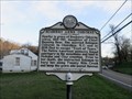
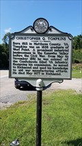
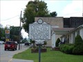
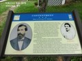
| Christopher Q. Tompkins / Gauley Mount in West Virginia Historical Markers A two sided sign that gives a short history of Christopher Q. Tompkins and his nearby home. posted by: dukemartin location: West Virginia date approved: 09/04/2021 last visited: never |
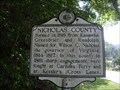 view gallery view galleryNW8.9 km | Nicholas County / Clay County in West Virginia Historical Markers Tells where the counties were formed from and how they received their names. posted by: Paintedwarrior location: West Virginia date approved: 08/08/2012 last visited: 08/11/2012 |
 view gallery view gallery SE9.3 km SE9.3 km
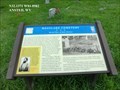
| Westlake Cemetery-Burial Place of Julia Jackson - Ansted WV in U.S. Civil War Sites The cemetery is kown for the grave of Julia Beckwith Neale Jackson Woodson, the mother of Thomas J. “Stonewall” Jackson. She was born on February 28, 1798, in Loudoun County, Virginia. posted by: Don.Morfe location: West Virginia date approved: 07/01/2023 last visited: 07/01/2023 |
 view gallery view gallerySE9.3 km | Westlake Cemetery-Burial Place of Julia Jackson - Ansted WV in Civil War Discovery Trail Sites This is one of the earliest identified cemeteries west of the Allegheny Mountains. The cemetery is best known for the grave of Julia Beckwith Neale Jackson Woodson, the mother of Thomas J. “Stonewall” Jackson. posted by: Don.Morfe location: West Virginia date approved: 08/10/2020 last visited: 10/05/2021 |
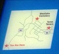
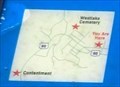
 view gallery view gallerySE9.3 km |  'You Are Here' Maps-Westlake Cemetery-Burial Place of Julia Jackson - Ansted WV 'You Are Here' Maps-Westlake Cemetery-Burial Place of Julia Jackson - Ansted WV
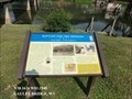
in 'You Are Here' Maps The 'You Are Here' Maps shows that you are at Westlake Cemetery on Cemetery Street in Ansted WV. posted by: Don.Morfe location: West Virginia date approved: 10/05/2023 last visited: 10/05/2023 |
 view gallery view gallerySE9.3 km | Jackson's Mother in West Virginia Historical Markers The mother of General Thomas J. "Stonewall" Jackson posted by: two-bit Joe location: West Virginia date approved: 11/18/2007 last visited: 08/04/2012 |
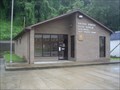 view gallery view gallerySW9.5 km | Glenn Ferris WV 25090 Post Office in U.S. Post Offices Glenn Ferris WV 25090 Post Office posted by: dukemartin location: West Virginia date approved: 08/17/2013 last visited: never |
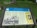
 view gallery view gallerySW9.5 km | Camp Reynolds in West Virginia Historical Markers Civil War camp for Union Army posted by: two-bit Joe location: West Virginia date approved: 11/19/2007 last visited: 08/31/2023 |
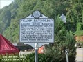 view gallery view gallerySW9.5 km | Camp Reynolds - Glen Ferris WV in American Civil War Monuments and Memorials Marker is located on Route US 60, Glen Ferris, Feyette County, WV.
Marker Program Sponsor: Elkin Metals / West Virginia Department of Culture and History, erected in 1991. posted by: Don.Morfe location: West Virginia date approved: 09/06/2023 last visited: 09/06/2023 |
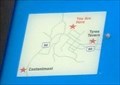
 view gallery view galleryS9.5 km | Contentment-Home of George W. Imboden - Ansted WV in U.S. Civil War Sites After the Civil War, George W. Imboden lived here with his wife, Mary Tyree, the daughter of William Tyree of Tyree Tavern. When the war began, Imboden enlisted in the Staunton Artillery in Augusta County, Virginia, where he then resided. posted by: Don.Morfe location: West Virginia date approved: 07/01/2023 last visited: 07/01/2023 |
 view gallery view galleryS9.5 km | 'You Are Here' Maps-Contentment-Home of George W. Imboden - Ansted WV in 'You Are Here' Maps The 'You Are Here' Map shows that you are on U.S. 60 in Ansted WV. posted by: Don.Morfe location: West Virginia date approved: 10/05/2023 last visited: 10/05/2023 |
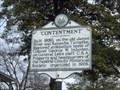 view gallery view galleryS9.5 km | “Contentment” in West Virginia Historical Markers Home of Colonel George W. Imboden posted by: two-bit Joe location: West Virginia date approved: 11/19/2007 last visited: 10/04/2023 |
 view gallery view gallerySW9.7 km | Kanawha Falls in Waterfalls Short but wide falls along US 60. posted by: wardnkathy location: West Virginia date approved: 10/11/2009 last visited: 10/19/2013 |
 view gallery view gallerySE9.7 km | Tyree Tavern-Confederate and Union Headquarters - Ansted WV in Civil War Discovery Trail Sites During his and Gen. Henry Alexander Wise’s unsuccessful Kanawha Valley campaign, Confederate Gen. John B. Floyd made his headquarters here, August 17-18, 1861. posted by: Don.Morfe location: West Virginia date approved: 08/11/2020 last visited: 10/05/2021 |
 view gallery view gallerySE9.7 km | Tyree Tavern-Confederate and Union Headquarters - Ansted WV in U.S. Civil War Sites During his and Gen. Henry Alexander Wise’s unsuccessful Kanawha Valley campaign, Confederate Gen. John B. Floyd made his headquarters here, August 17-18, 1861, while Wise camped on the top of Big Sewell Mountain. posted by: Don.Morfe location: West Virginia date approved: 07/01/2023 last visited: 07/01/2023 |
 view gallery view gallerySE9.7 km | 'You Are Here' Maps-Tyree Tavern-Confederate and Union Headquarters - Ansted WV in 'You Are Here' Maps The 'You Are Here' Map shows that you are at the intersection of James River and Kanawha Turnpike (County Route 60/33) and Tyree Street
Ansted, WV USA 25812 posted by: Don.Morfe location: West Virginia date approved: 10/05/2023 last visited: 10/05/2023 |
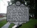 view gallery view gallerySE9.7 km | Halfway House in West Virginia Historical Markers A sign telling us a short history of the Tyree Tavern. posted by: Paintedwarrior location: West Virginia date approved: 08/25/2013 last visited: 08/30/2013 |
|