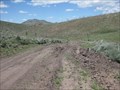
 view gallery view gallery W37.5 km W37.5 km
|   White Rock Range Wilderness - NV White Rock Range Wilderness - NV
in Public Access Lands The White Rock Mountain Wilderness provides access to hiking, hunting, off roading (ATV/UTV) and wildlife viewing. posted by:  ChapterhouseInc ChapterhouseInc location: Nevada date approved: 06/20/2011 last visited: 06/15/2011 |
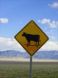 view gallery view gallery N40.4 km N40.4 km
|  Skateboarding Cow Crossing! Skateboarding Cow Crossing!
in Uncommon Crossing Signs Skateboarding Cow Crossing! posted by: The_Simpsons location: Utah date approved: 10/03/2011 last visited: 01/23/2013 |
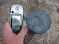
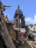
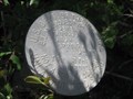 view gallery view galleryW40.6 km |  Seven Trough Springs - White Rock Range WMA Seven Trough Springs - White Rock Range WMA
in U.S. Benchmarks One of many springs found in the White Rock Range. Set near the gate on west side. posted by: ChapterhouseInc location: Nevada date approved: 06/29/2011 last visited: 06/22/2011 |
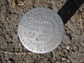
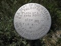 view gallery view galleryW40.9 km | Lion Spring - White Rock Mountain Wilderness Area in U.S. Benchmarks A benchmark set near the southwest corner protecting the fence. posted by: ChapterhouseInc location: Nevada date approved: 06/19/2011 last visited: 06/14/2011 |
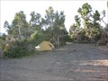 view gallery view galleryW41.2 km |  White Rock Range Wilderness Camping Areas - NV White Rock Range Wilderness Camping Areas - NV
in Free Campsites There are several assorted camping areas scattered around the White Rock Mountain Wilderness. posted by: ChapterhouseInc location: Nevada date approved: 08/14/2011 last visited: 06/14/2011 |
 view gallery view gallery NE45.2 km NE45.2 km
| Benchmark: JO0456 in U.S. Benchmarks We came across this U.S. Geological Survey Disc near the Ghost town of Frisco, Utah. posted by: JacobBarlow location: Utah date approved: 09/18/2007 last visited: 10/02/2011 |
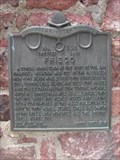 view gallery view galleryNE45.4 km |  Frisco Frisco
in Utah Historical Markers A typical mining town at the foot of the San Francisco mountains was fed by the fabulously rich Horn Silver Mine... posted by: JacobBarlow location: Utah date approved: 09/07/2007 last visited: 03/26/2020 |
 view gallery view galleryNE45.4 km |  Frisco - 268 Frisco - 268
in D.U.P. Historic Markers A typical mining town at the foot of the San Francisco mountains was fed by the fabulously rich Horn Silver Mine. posted by:  Mooroid Mooroid location: Utah date approved: 10/03/2011 last visited: 03/27/2020 |
 view gallery view galleryW45.5 km |  Spring Valley Cemetery - State Line Canyon, Pioche, NV Spring Valley Cemetery - State Line Canyon, Pioche, NV
in Worldwide Cemeteries A small cemetery with few surviving headstones in the BLM Ely district near Pioche. There are 15 graves listed. posted by: ChapterhouseInc location: Nevada date approved: 03/13/2012 last visited: 08/07/2011 |
 view gallery view galleryW45.5 km |  Spring Valley Cemetery - State Line Canyon, Pioche, NV Spring Valley Cemetery - State Line Canyon, Pioche, NV
in Abandoned Cemeteries A small cemetery with few surviving headstones in the BLM Ely district near Pioche. There are 15 graves listed. posted by: ChapterhouseInc location: Nevada date approved: 03/08/2012 last visited: 08/07/2011 |
 view gallery view galleryNE45.9 km |  Frisco, Utah Frisco, Utah
in Ghost Towns Frisco was founded August 21, 1871 and was abandoned in the early 1920's. The mines produced $80,000,000 in ore, primarily silver and lead, and at one time the city boost a population of 6,000. posted by: maritimedriver location: Utah date approved: 06/28/2006 last visited: 10/03/2011 |
 view gallery view galleryW48.1 km | Ranch Campground and Trailhead - Spring Valley State Park in Campgrounds A smaller campground north of the main campground at Spring Valley State Park. posted by: ChapterhouseInc location: Nevada date approved: 08/31/2011 last visited: 07/24/2011 |
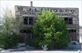 view gallery view gallery SW50.1 km SW50.1 km
|  B. J. LUND Co. ... ... HOTEL - Modena, Utah B. J. LUND Co. ... ... HOTEL - Modena, Utah
in Ghost Signs Old building in Modena Utah. posted by: nvtriker location: Utah date approved: 05/26/2009 last visited: never |
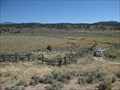
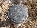 view gallery view gallerySW50.5 km | T2NR69E - USDOI BLM in U.S. Benchmarks Set in a pulloff for Spring Lake State Park. posted by: ChapterhouseInc location: Nevada date approved: 08/11/2011 last visited: 08/07/2011 |
 view gallery view galleryW52.3 km | Parsnip Pipeline - USDOI in U.S. Benchmarks One of two benchmarks set and the end of this wilderness access road. posted by: ChapterhouseInc location: Nevada date approved: 08/11/2011 last visited: 07/19/2011 |
 view gallery view galleryW52.3 km | Parsnip Fire Rehab - USDOI BLM in U.S. Benchmarks One of two benchmarks set and the end of this wilderness access road. posted by: ChapterhouseInc location: Nevada date approved: 08/11/2011 last visited: 07/19/2011 |
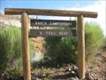
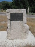 view gallery view gallerySW54.2 km |  Eagle Valley Fort Eagle Valley Fort
in Nevada Historical Markers An old marker notating Brigham Youngs directive to settle this valley. posted by: ChapterhouseInc location: Nevada date approved: 05/03/2012 last visited: 08/07/2011 |
 view gallery view gallery S55 km S55 km
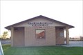
|  Pioneer Park - Beryl Junction, UT Pioneer Park - Beryl Junction, UT
in Municipal Parks and Plazas This modest park contains little other than a shelter and a monument - in Beryl Junction, Utah. posted by: The Snowdog location: Utah date approved: 01/01/2023 last visited: never |
 view gallery view galleryS59.9 km |  New Castle, Utah New Castle, Utah
in Wikipedia Entries I was surprised little New Castle even has a page, but there's not much to it yet. posted by: JacobBarlow location: Utah date approved: 02/01/2008 last visited: 02/12/2011 |
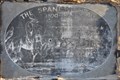 view gallery view galleryS59.9 km | The Spanish Trail ~ 1800-1850 in Utah Historical Markers This marker was placed where the Old Spanish Trail crosses Utah Highway 56 just east of New Castle, Utah. posted by: brwhiz location: Utah date approved: 05/18/2012 last visited: never |
 view gallery view galleryS59.9 km |  The Spanish Trail The Spanish Trail
in Wagon Roads and Trails This marker is located where the Old Spanish Trail crosses Utah Highway 56 just east of New Castle, Utah. posted by: brwhiz location: Utah date approved: 04/19/2012 last visited: never |
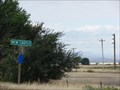
 view gallery view galleryS60 km |  New Castle, UT 84756 New Castle, UT 84756
in U.S. Post Offices New Castle, Utah 84756 posted by: PeanutsParents location: Utah date approved: 09/30/2007 last visited: 09/17/2011 |
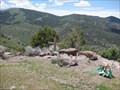
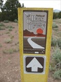 view gallery view galleryW60.4 km |  Mt Wilson Scenic Byway - NV Mt Wilson Scenic Byway - NV
in National Scenic Byways The Mt Wilson Back Country Byway passes over the Mt Wilson Range and provides a view of the surrounding area at its apex. posted by: ChapterhouseInc location: Nevada date approved: 06/18/2011 last visited: 06/16/2011 |
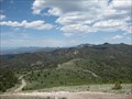 view gallery view galleryW60.4 km |  Mt Wilson Byway Lookout - NV Mt Wilson Byway Lookout - NV
in Scenic Roadside Look-Outs The Mt Wilson Scenic Byway passes over the Range and provides a view of the surrounding area at its apex. Mt Wilson is several hundred feet higher just to the west, and the peaks of Great Basin National Park to the north. posted by: ChapterhouseInc location: Nevada date approved: 06/18/2011 last visited: 06/16/2011 |
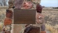
 view gallery view galleryW60.4 km |  Kim and Linda Lytle - Mt Wilson, NV Kim and Linda Lytle - Mt Wilson, NV
in Citizen Memorials Located atop the Mt Wilson Scenic Byway a memorial to people who frequented the area. posted by: ChapterhouseInc location: Nevada date approved: 06/18/2011 last visited: 06/16/2011 |
|