 view gallery view gallery NW1.4 km NW1.4 km
|   Grandola - Beja, Portugal Grandola - Beja, Portugal
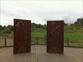
in Immortalized in Lyrics Grândola, Vila Morena, a music from Zeca Afonso posted by:  RuiJSDuarte RuiJSDuarte location: Beja, Portugal date approved: 04/01/2012 last visited: 04/16/2022 |
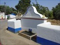
 view gallery view gallery SW2.4 km SW2.4 km
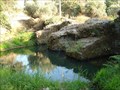
| ") Barragem romana do Pego da Moura - Grândola, Portugal Barragem romana do Pego da Moura - Grândola, Portugal
in Património Português (Portuguese Heritage) The Barragem do Pego da Moura, also known as Barragem do Pego da Mina, is a Roman water dam, located in Grândola, and was declared as public interest in December 31, 1997. posted by: tmob location: Setúbal, Portugal date approved: 01/26/2012 last visited: never |
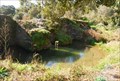 view gallery view gallerySW2.4 km |  Pego da Moura Water Dam Pego da Moura Water Dam
in Ancient Roman Civilization Pego da Moura Water Dam is a roman dam located in the Grândola municipality, district of Setúbal, and was declared to be a Building of Public Interest by the Decree 67/97 DR301 of December the 31st 1997. posted by:  manchanegra manchanegra location: Setúbal, Portugal date approved: 02/29/2008 last visited: 10/19/2011 |
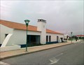
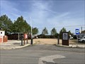
 view gallery view gallery E6 km E6 km
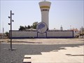
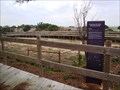
|  A2 - Área de Serviço de Grândola N-S A2 - Área de Serviço de Grândola N-S
in Highway Rest Areas Highway resting area near Grândola posted by: MightyReek location: Setúbal, Portugal date approved: 11/29/2010 last visited: 04/12/2011 |
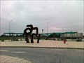
 view gallery view galleryE6.1 km |  Cantares Alentejanos - Grândola, Portugal Cantares Alentejanos - Grândola, Portugal
in Silhouette Public Art Sculptures This silhouette sculpture is located in an unusual place: on the grounds of a service station by the motorway posted by: Torgut location: Faro, Portugal date approved: 02/14/2021 last visited: never |
 view gallery view galleryE6.1 km | A2 - Área de Serviço de Grândola S-N in Highway Rest Areas Highway resting area near Grândola posted by: MightyReek location: Setúbal, Portugal date approved: 11/29/2010 last visited: 08/29/2010 |
 view gallery view gallerySW6.9 km |  Fonte de Santa Margarida da Serra/Grândola/Setubal/Portugal Fonte de Santa Margarida da Serra/Grândola/Setubal/Portugal
in Fountains "The fountain has never dried up even in very dry years"were the words spoken by the elders of the village. posted by: 100stress location: Setúbal, Portugal date approved: 04/11/2011 last visited: 11/28/2010 |
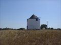 view gallery view gallerySW7.1 km |  Moinho de Santa Margarida da Serra/Grândola/Setúbal/Portugal Moinho de Santa Margarida da Serra/Grândola/Setúbal/Portugal
in Windmills This is one of many mills with more than 200 years that there are in the hills of Grândula. posted by: 100stress location: Setúbal, Portugal date approved: 04/11/2011 last visited: 11/28/2010 |
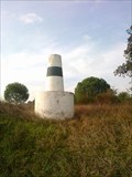
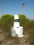 view gallery view gallery W11.7 km W11.7 km
|  BOAVISTA BOAVISTA
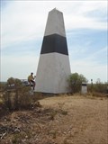
in Portugal Geodetic Points Marco geodésico BOAVISTA
Coordenadas: N38° 08.212 W008° 41.185 posted by: MightyReek location: Setúbal, Portugal date approved: 10/02/2009 last visited: never |
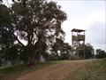 view gallery view gallerySW12.4 km |  Look-Out Tower - Melides, Portugal Look-Out Tower - Melides, Portugal
in Look-Out Towers A wood made Look-Out Tower. posted by: RuiJSDuarte location: Setúbal, Portugal date approved: 12/17/2013 last visited: 06/09/2013 |
 view gallery view gallery SE14 km SE14 km
| Encruzilhada in Portugal Geodetic Points Nome: Encruzilhada
Coordenadas: N38º 06.934 W008º 25.127
Altitude: 77 metros posted by: MightyReek location: Setúbal, Portugal date approved: 12/01/2011 last visited: 07/23/2023 |
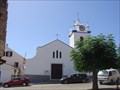 view gallery view galleryW15 km |  Igreja Paroquial de São Pedro - Melides/Setubal/Portugal Igreja Paroquial de São Pedro - Melides/Setubal/Portugal
in This Old Church On November 7, 1634 comes a letter to the King for permission to build a new church, which became the Parish of St. Temple Peter, patron of the new parish. This church would be totally destroyed by the earthquake of 1755, and subsequently rebuilt. posted by: 100stress location: Setúbal, Portugal date approved: 04/15/2011 last visited: 07/29/2023 |
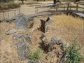
 view gallery view gallerySW15.3 km |  Cistas das Casas Velhas - Melides, Portugal Cistas das Casas Velhas - Melides, Portugal
in Worldwide Cemeteries "Isolated and located in a rural area, the burial ground have been used between sec.XV BC and sec.VII BC and is a funerary group consisting of multiple run honeycomb cistas, arranged in two distint areas each of about 30m2." posted by: RuiJSDuarte location: Setúbal, Portugal date approved: 01/27/2014 last visited: never |
 view gallery view galleryW15.3 km | Rice Workers - Melides, Grandôla, Portugal in Silhouette Public Art Sculptures A silhouette public art example is on display by a public roadside park, close to the village entrance of Melides. It depicts a couple of traditional (man and woman) rice farmers. posted by: SUp3rFM & Cruella location: Setúbal, Portugal date approved: 10/14/2011 last visited: never |
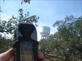
 view gallery view gallerySE17.4 km | Barros - PE in Portugal Geodetic Points The Geodesic Vertex Barros-PE
Locally known as "gurita", the landmark that I propose that you visit is an extremely impressive and imposing structure. Here’s a summary of the place:
O Vértice Geodésico Barros-PE
Localmente conhecido como "gurita", o marco que vos proponho visitar é uma estrutura realmente impressionante e imponente.
Aqui está um resumo do local:
posted by: MightyReek location: Setúbal, Portugal date approved: 07/19/2009 last visited: 09/11/2010 |
 view gallery view gallerySE17.9 km |  Monumento Megalítico do Lousal Monumento Megalítico do Lousal
in Megalithic Monuments Monumento Megalítico do Lousal - Período Calcolítico - 2000
Lousal's Megalíthic Monument - Calcolithic Period 2000 b. C. posted by: MightyReek location: Setúbal, Portugal date approved: 07/19/2009 last visited: 07/31/2016 |
  S18.3 km S18.3 km
|  Monte Naturista O Barão Monte Naturista O Barão
in Nude Beaches Naturist Campsite
Parque Campismo Naturista posted by: MightyReek location: Setúbal, Portugal date approved: 07/26/2009 last visited: 05/30/2009 |
 view gallery view galleryS18.5 km | ABELA in Portugal Geodetic Points Marco geodésico: ABELA
Coordenadas: 38° 00.336 W008° 33.493
posted by: MightyReek location: Setúbal, Portugal date approved: 10/02/2009 last visited: never |
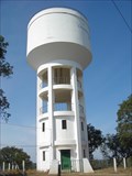 view gallery view galleryS18.5 km |  Depósito de água de Abela Depósito de água de Abela
in Water Towers Water Tower for Abela posted by: MightyReek location: Setúbal, Portugal date approved: 10/02/2009 last visited: never |
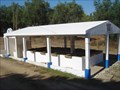 view gallery view gallerySW18.8 km | ") Lavadouro de Santa Cruz Lavadouro de Santa Cruz
in Lavoir (wash houses) Lavadouro Público de Santa Cruz
Santa Cruz Public Lavoir posted by: MightyReek location: Setúbal, Portugal date approved: 10/02/2009 last visited: never |
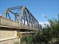 view gallery view galleryE18.8 km |  Ponte de Santa Margarida do Sado Ponte de Santa Margarida do Sado
in Truss Bridges Truss Bridge over Rio Sado in Portugal. posted by: MightyReek location: Setúbal, Portugal date approved: 07/19/2009 last visited: 04/12/2011 |
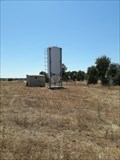 view gallery view gallerySE19 km |  Cereal Silo - Minas do Lousal, Portugal Cereal Silo - Minas do Lousal, Portugal
in Solitary Silos A solitary silo near Minas do Lousal posted by: tmob location: Setúbal, Portugal date approved: 09/09/2021 last visited: never |
 view gallery view gallerySE19 km |  Alentejo Ribatejo - Lousal, Portugal Alentejo Ribatejo - Lousal, Portugal
in Free Overnight RV Parking Locations Gratis camperspace with electricity posted by: GEOrgCACHING location: Évora, Portugal date approved: 04/08/2024 last visited: 04/08/2024 |
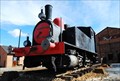 view gallery view gallerySE19.3 km |  Lousal Mines Locomotive #1 - Lousal, Portugal Lousal Mines Locomotive #1 - Lousal, Portugal
in Locomotives Ancient locomotive used to transport ore from the Lousal mines to the nearby major raillroad. posted by: manchanegra location: Setúbal, Portugal date approved: 02/22/2009 last visited: 04/06/2024 |
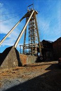 view gallery view gallerySE19.3 km |  Lousal Mines - Portugal Lousal Mines - Portugal
in Mines Lousal Mine was explored between 1900 and 1988 and is located in the Iberian Pyrit Belt. posted by: manchanegra location: Setúbal, Portugal date approved: 04/16/2009 last visited: 09/09/2007 |
|