 view gallery view gallery W0.8 km W0.8 km
|   Morehead Utility Plant Board WWTP - Morehead, KY, USA Morehead Utility Plant Board WWTP - Morehead, KY, USA
in Wastewater Treatment Facilities The MUPB Wastewater Plant, located at 175 Bullfork Road, operates 24 hours a day, 7 days a week. posted by:  Simplenfun Simplenfun location: Kentucky date approved: 08/20/2011 last visited: 10/11/2016 |
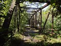 view gallery view galleryW1.1 km |  Old US 60 Iron Bridge - Freestone Road, KY, USA Old US 60 Iron Bridge - Freestone Road, KY, USA
in Truss Bridges This bridge was built in 1921 across Triplett Creek in Rowan County, Kentucky on what was then Route US 60 West of Morehead, KY. posted by: Simplenfun location: Kentucky date approved: 10/18/2011 last visited: 10/11/2016 |
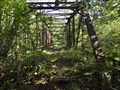 view gallery view galleryW1.1 km |  Old US 60 Iron Bridge - Freestone Road, KY, USA Old US 60 Iron Bridge - Freestone Road, KY, USA
in Orphaned Bridges This orphaned bridge is located in Rowan County, Kentucky west of Morehead on Freestone Road which used to be US 60. posted by: Simplenfun location: Kentucky date approved: 10/23/2016 last visited: 10/26/2016 |
 view gallery view gallery E1.8 km E1.8 km
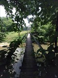
|  Sheltowee Trace trail over Triplett Creek, KY Sheltowee Trace trail over Triplett Creek, KY
in Pedestrian Suspension Bridges About 800 feet south of US-60.
posted by:  wuja wuja location: Kentucky date approved: 06/17/2007 last visited: 07/25/2011 |
 view gallery view galleryE1.8 km |  Shelltowee Trace Footbridge triplett creek - Morehead, KY, US Shelltowee Trace Footbridge triplett creek - Morehead, KY, US
in Hiking Path Footbridges Limestone Connector #109A (1.7 miles) Begins at US 60 and travels south, crossing a swinging bridge over Triplett Creek, then ends at the Sheltowee Trace on Limestone Ridge. posted by: Crazy4horses location: Kentucky date approved: 04/26/2016 last visited: 04/27/2016 |
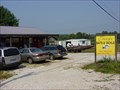 view gallery view galleryW1.9 km |  Jerry's Baits and Tackle - Farmers Kentucky Jerry's Baits and Tackle - Farmers Kentucky
in Bait Shops Located 1.5 miles east of Farmers on US 60. posted by: Simplenfun location: Kentucky date approved: 01/18/2017 last visited: 10/11/2016 |
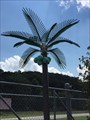 view gallery view galleryW2.9 km |  Cave Run Bingo Electric Palm Trees - Farmers, KY, US Cave Run Bingo Electric Palm Trees - Farmers, KY, US
in Electric Palm Trees Located on east U.S. 60 out of farmers Kentucky. posted by: Crazy4horses location: Kentucky date approved: 08/02/2016 last visited: 10/10/2016 |
 view gallery view gallery SE2.9 km SE2.9 km
|  Rowan County High Point - KY, USA Rowan County High Point - KY, USA
in Geographic High Points The highest elevation in the county is Limestone Knob (1435 ft), situated approximately 3 miles southwest of Morehead posted by: Crazy4horses location: Kentucky date approved: 01/04/2017 last visited: 01/04/2017 |
 view gallery view galleryW3.2 km |  General Hood Birthplace - Owingsville, Kentucky General Hood Birthplace - Owingsville, Kentucky
in Kentucky Historical Markers Located on E. Main Street or US 60 in Owingsville, this marker refers to the birthplace of General Hood, a graduate of West Point and hero of the Civil War. posted by: BluegrassCache location: Kentucky date approved: 12/01/2008 last visited: 07/27/2011 |
 view gallery view galleryW3.2 km |  St. Julie Catholic Church - Owingsville, KY St. Julie Catholic Church - Owingsville, KY
in Roman Catholic Churches St. Julie Catholic Church is located on Main Street in Owingsville, Kentucky. The cornerstone above the door hints at the churches past as a Presbyterian Church built in 1887. posted by: BluegrassCache location: Kentucky date approved: 01/07/2009 last visited: 07/27/2011 |
 view gallery view gallery S3.2 km S3.2 km
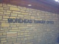
|  Morehead Ranger District - Safe Place Morehead Ranger District - Safe Place
in Safe Place Havens This Cumberland District Ranger Station of the Daniel Boone National Forest is also a Safe Haven! posted by: Simplenfun location: Kentucky date approved: 08/29/2011 last visited: 10/11/2016 |
 view gallery view galleryW3.5 km |  Farmers, KY 40319 Farmers, KY 40319
in U.S. Post Offices Small community near Cave Run Lake posted by: SportsPhotoGuy location: Kentucky date approved: 05/30/2010 last visited: 08/17/2011 |
 view gallery view galleryW3.5 km |  Farmers Elementary School - Farmers, KY, USA Farmers Elementary School - Farmers, KY, USA
in Former Schools This former school was an antique mall for awhile, but now abandoned. posted by: Simplenfun location: Kentucky date approved: 08/19/2011 last visited: 10/11/2016 |
 view gallery view galleryW3.5 km |  Farmers Elementary School Farmers Elementary School
in WPA Projects This former school was constructed as a WPA project. For awhile, it served as an antique mall. Now it is vacant and overgrown with vegetation on the outside. posted by: Simplenfun location: Kentucky date approved: 08/25/2011 last visited: 10/11/2016 |
 view gallery view gallery SW3.7 km SW3.7 km
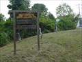
|  Cumberland Ranger District - Cave Run Lake, KY, US Cumberland Ranger District - Cave Run Lake, KY, US
in Ranger Stations Cumberland Ranger District
2375 KY 801 South
Morehead, KY 40351
606-784-6428 posted by: Crazy4horses location: Kentucky date approved: 08/09/2016 last visited: 10/10/2016 |
 view gallery view gallerySW3.7 km | Cumberland Ranger District - Daniel Boone National Forest - KY, USA in Ranger Stations The Daniel Boone National Forest is divided into four ranger districts. posted by: Simplenfun location: Kentucky date approved: 08/28/2011 last visited: 10/11/2016 |
 view gallery view gallerySW3.7 km |  Cumberland District Ranger Station Overlook - DBNF - KY, USA Cumberland District Ranger Station Overlook - DBNF - KY, USA
in Scenic Overlooks One of the best things about this ranger station is the nice view from the walkout overlook at the rear of the building! posted by: Simplenfun location: Kentucky date approved: 08/29/2011 last visited: 10/11/2016 |
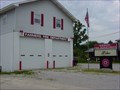 view gallery view galleryW3.9 km |  Farmers Fire Department Farmers Fire Department
in Firehouses This fire department operates out of 2 stations that protect a primarily rural area of 34 1/2 square miles with a population of around 4000 people. posted by: Simplenfun location: Kentucky date approved: 10/25/2016 last visited: 10/26/2016 |
 view gallery view galleryW3.9 km |  Ingram Stevens Cemetery est. 1884 - Farmers, KY, USA Ingram Stevens Cemetery est. 1884 - Farmers, KY, USA
in Worldwide Cemeteries Very small well-kept roadside cemetery located in Farmers, KY! posted by: Simplenfun location: Kentucky date approved: 09/01/2011 last visited: 10/11/2016 |
 view gallery view gallery N3.9 km N3.9 km
|  Rowan County Public Library - Morehead, KY Rowan County Public Library - Morehead, KY
in Libraries This new 17,000 square-foot facility opened its doors to the public on Aug. 30, 2010. posted by: Simplenfun location: Kentucky date approved: 08/26/2011 last visited: 10/11/2016 |
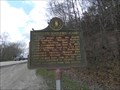 view gallery view galleryW4 km | Kentucky Historical Marker No. 567 in Kentucky Historical Markers During the final Kentucky raid, Morgan's Raiders camped here in 1864. posted by: Simplenfun location: Kentucky date approved: 04/05/2011 last visited: 10/11/2016 |
 view gallery view gallerySW4.2 km | Cave Run Lake Scenic Overlook in Scenic Overlooks One of the beautiful views of Cave Run Lake! posted by: Simplenfun location: Kentucky date approved: 08/29/2011 last visited: 10/11/2016 |
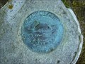 view gallery view gallerySW4.2 km |  Cave Run Lake Scenic Overlook Survey Mark Cave Run Lake Scenic Overlook Survey Mark
in U.S. Benchmarks Disk located near scenic viewing area of Cave Run Lake. posted by: Simplenfun location: Kentucky date approved: 08/28/2011 last visited: 10/11/2016 |
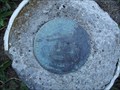 view gallery view gallerySW4.2 km | Cave Run Lake Reset in U.S. Benchmarks Reset disk located on North Rowan County end of Cave Run Lake dam. posted by: Simplenfun location: Kentucky date approved: 08/28/2011 last visited: 10/11/2016 |
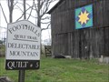 view gallery view galleryW4.5 km |  Delectable Mountain Quilt Square - Rowan County, KY Delectable Mountain Quilt Square - Rowan County, KY
in Painted Barn Quilts This painted barn quilt is part of the Rowan County, KY Foothills Quilt Trail Project. posted by: Simplenfun location: Kentucky date approved: 04/05/2011 last visited: 10/11/2016 |
|