 view gallery view gallery E0.2 km E0.2 km
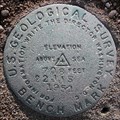
|   USGS 22 JJS 708 1951, Bath County, KY USGS 22 JJS 708 1951, Bath County, KY
in U.S. Benchmarks About 25 feet south of US-60, west of the church parking lot. The post is leaning about 30 degrees north, projects about 1 foot and might have been moved. posted by:  wuja wuja location: Kentucky date approved: 11/19/2007 last visited: never |
 view gallery view gallery SE4 km SE4 km
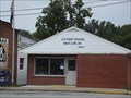
|  Salt Lick, Kentucky, 40371 Salt Lick, Kentucky, 40371
in U.S. Post Offices Salt Lick is a city in Bath County, Kentucky, United States. The population was 342 at the 2000 census. posted by:  Simplenfun Simplenfun location: Kentucky date approved: 08/21/2011 last visited: 10/11/2016 |
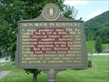 view gallery view gallerySE4 km |  Iron Made in Kentucky Iron Made in Kentucky
in Kentucky Historical Markers One side of this marker provides a brief history of iron making in Kentucky. The other side provides a history of nearby Clear Creek Furnace which is also a waymark. posted by: Simplenfun location: Kentucky date approved: 08/11/2011 last visited: 10/11/2016 |
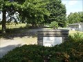
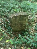 view gallery view gallerySE5.1 km |  Lower Salt Lick Cemetery - Salt Lick, KY, US Lower Salt Lick Cemetery - Salt Lick, KY, US
in Worldwide Cemeteries Located on South Hwy 211. Cemetery is approximately 1.5 miles. Turn right on small gravel road just before little blue house. posted by: Crazy4horses location: Kentucky date approved: 12/20/2016 last visited: 12/20/2016 |
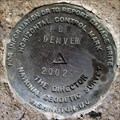 view gallery view gallery W6 km W6 km
| FBN DENVER, DG7982, Bath County, KY in U.S. Benchmarks Federal Base Network A-order horizontal control mark. Not on geocaching.com since it was monumented in 2002. posted by: wuja location: Kentucky date approved: 11/19/2007 last visited: 07/27/2011 |
 view gallery view gallery N6.4 km N6.4 km
|  Spurlock Gap - Rowan County, KY, US Spurlock Gap - Rowan County, KY, US
in Named Mountain Gaps Spurlock Gap located on Rowan County and Fleming County line on Lower Licking Road. posted by: Crazy4horses location: Kentucky date approved: 01/12/2017 last visited: 01/02/2017 |
 view gallery view galleryE7.1 km | Jones Cemetery - Salt Lick, KY, USA in Worldwide Cemeteries This is a rural cemetery with approximately 1200 graves located in a community known as Midland. posted by: Simplenfun location: Kentucky date approved: 08/18/2011 last visited: 10/11/2016 |
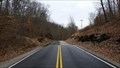
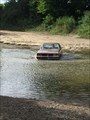 view gallery view gallery NW7.1 km NW7.1 km
|  Slate Creek Ford - Bath County, KY, US Slate Creek Ford - Bath County, KY, US
in Bridgeless Water Crossings Directions: KY 111 N of Owingsville right on Waterdell Road, continue past the dam to Slate Creek Ford. posted by: Crazy4horses location: Kentucky date approved: 08/16/2016 last visited: 10/10/2016 |
 view gallery view galleryE7.1 km | Bath County Memorial Gardens in Worldwide Cemeteries Located off of US 60 on Old River Road posted by: Simplenfun location: Kentucky date approved: 10/11/2016 last visited: 12/21/2016 |
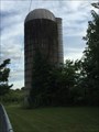 view gallery view galleryW7.2 km |  I-64 Mortorplex silo - Owingsville, KY, US I-64 Mortorplex silo - Owingsville, KY, US
in Solitary Silos I-64 Motorplex located in Owingsville, Kentucky, at exit 123 off I-64. posted by: Crazy4horses location: Kentucky date approved: 08/16/2016 last visited: 10/10/2016 |
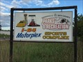 view gallery view galleryW7.2 km |  I-64 Motorplex - Owingsville, KY, US I-64 Motorplex - Owingsville, KY, US
in Racetracks I-64 Motorplex is a 1/8th mile IHRA sanctioned dragstrip located in Owingsville, Kentucky, at exit 123 off I-64. posted by: Crazy4horses location: Kentucky date approved: 08/16/2016 last visited: 10/10/2016 |
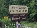 view gallery view gallerySE8 km |  White Sulphur ATV Trial - Salt Lick, KY, US White Sulphur ATV Trial - Salt Lick, KY, US
in Offroad Trails From I-64 East, take exit 123. Travel east on KY 60 and turn right on KY 211 to Salt Lick.
From KY 211, turn left onto Forest Service Road 129. Just past the Clear Creek Country Store, turn left onto Forest Service Road 105 posted by: Crazy4horses location: Kentucky date approved: 08/03/2016 last visited: 10/10/2016 |
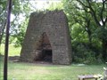 view gallery view galleryW8.7 km |  Bourban Iron Works (Slate Creek Furnace) Bourban Iron Works (Slate Creek Furnace)
in Iron Furnace Ruins Old furnace in Central KY posted by: kbarhow location: Kentucky date approved: 06/30/2007 last visited: 06/11/2021 |
 view gallery view galleryE9 km |  ISS Site 2 Farmers KY. - Site 1 Plano TX.- Site 1B Broken Arrow OK ISS Site 2 Farmers KY. - Site 1 Plano TX.- Site 1B Broken Arrow OK
in International Space Station Sightings ISS flew over crazy4horses Peak Site 1A (Plano TX) at 6:00:33 AM Central Time
ISS flew over gramakitty Site 1B (Broken Arrow OK) at 6:00:17 AM Central Time
ISS flew over simplenfun Site 2 (Farmers KY) at 6:02:59 AM Central Time on November 3, 20 posted by: Simplenfun location: Kentucky date approved: 11/05/2016 last visited: 11/05/2016 |
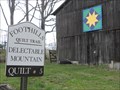 view gallery view galleryE9 km |  Delectable Mountain Quilt Square - Rowan County, KY Delectable Mountain Quilt Square - Rowan County, KY
in Painted Barn Quilts This painted barn quilt is part of the Rowan County, KY Foothills Quilt Trail Project. posted by: Simplenfun location: Kentucky date approved: 04/05/2011 last visited: 10/11/2016 |
 view gallery view gallerySE9 km | White Sulphur Cemetery in Worldwide Cemeteries This is a very small cemetery located near Salt Lick, Kentucky, USA. There are approximately 25 graves here. posted by: Simplenfun location: Kentucky date approved: 08/15/2011 last visited: 10/11/2016 |
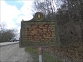 view gallery view galleryE9.3 km | Kentucky Historical Marker No. 567 in Kentucky Historical Markers During the final Kentucky raid, Morgan's Raiders camped here in 1864. posted by: Simplenfun location: Kentucky date approved: 04/05/2011 last visited: 10/11/2016 |
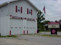 view gallery view galleryE9.5 km |  Farmers Fire Department Farmers Fire Department
in Firehouses This fire department operates out of 2 stations that protect a primarily rural area of 34 1/2 square miles with a population of around 4000 people. posted by: Simplenfun location: Kentucky date approved: 10/25/2016 last visited: 10/26/2016 |
 view gallery view galleryE9.5 km | Ingram Stevens Cemetery est. 1884 - Farmers, KY, USA in Worldwide Cemeteries Very small well-kept roadside cemetery located in Farmers, KY! posted by: Simplenfun location: Kentucky date approved: 09/01/2011 last visited: 10/11/2016 |
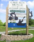 view gallery view galleryE9.5 km |  Cave Run Bicycle and Outdoor Center Cave Run Bicycle and Outdoor Center
in Outdoor Recreation Stores Cave Run Bicycle and Outdoor Center is a full service shop. posted by: bdpalace location: Kentucky date approved: 05/17/2007 last visited: 08/09/2016 |
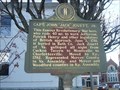 view gallery view galleryW9.7 km | Capt. John "Jack" Jouett, Jr. - Owingsville, KY in Kentucky Historical Markers This marker refers to Capt. John "Jack" Jouett, Jr., a famous Revolutionary War hero, who rode 40 miles to warn Jefferson, Patrick Henry and other legislators of British Approach. posted by: BluegrassCache location: Kentucky date approved: 12/01/2008 last visited: 07/27/2011 |
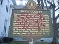 view gallery view galleryW9.7 km | Bath County - Owingsville, Kentucky in Kentucky Historical Markers In 1811, Bath County was formed from Montgomery County. It has a colorful history, including having one of 22 courthouses that were burned in Kentucky during the Civil War. posted by: BluegrassCache location: Kentucky date approved: 11/30/2008 last visited: 07/27/2011 |
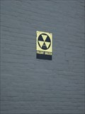 view gallery view galleryW9.7 km |  Bath County Courthouse Fallout Shelter - Owingsville, KY Bath County Courthouse Fallout Shelter - Owingsville, KY
in Civil Defense Fallout Shelters This fallout shelter is located in the Bath County Courthouse located in downtown Owingsville, Kentucky. The sign is in very good condition but there is no capacity number on it. posted by: BluegrassCache location: Kentucky date approved: 11/29/2008 last visited: 07/27/2011 |
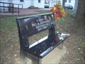 view gallery view galleryW9.7 km |  Paul M. Goodpaster - Owingsville, KY Paul M. Goodpaster - Owingsville, KY
in Dedicated Benches This bench, dedicated to Paul M. Goodpaster, Bath County PVA 1977-2007 sits in front of the Bath County Courthouse in Owingsville, Kentucky. posted by: BluegrassCache location: Kentucky date approved: 11/29/2008 last visited: never |
 view gallery view galleryW9.7 km |  Bath County Courthouse - Owingsville, KY Bath County Courthouse - Owingsville, KY
in Courthouses Bath County's courthouse is located in downtown Owingsville, Kentucky. It, and the buildings surrounding it in Courthouse Square are listed on the National Register of Historic Places posted by: BluegrassCache location: Kentucky date approved: 11/29/2008 last visited: 07/27/2011 |
|