 view gallery view gallery N5 km N5 km
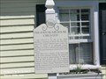
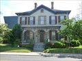
|   The John Blair House - Snow Hill MD The John Blair House - Snow Hill MD
in People-Named Places The John Blair House Circa 1835 is long believed to be one of the oldest dwellings remaining in Snow Hill. posted by:  Don.Morfe Don.Morfe location: Maryland date approved: 04/05/2023 last visited: 05/13/2023 |
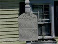 view gallery view galleryN5 km |  The John Blair House - Snow Hill MD The John Blair House - Snow Hill MD
in Signs of History The John Blair House Circa 1835 is long believed to be one of the oldest dwellings remaining in Snow Hill. posted by: Don.Morfe location: Maryland date approved: 08/24/2021 last visited: 04/15/2023 |
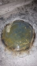
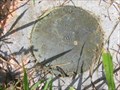
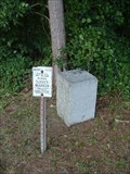
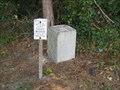
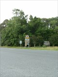
 view gallery view galleryN6 km |  DG4025: PURNELL (MDBCS/NGS, Snow Hill, MD) DG4025: PURNELL (MDBCS/NGS, Snow Hill, MD)
in U.S. Benchmarks A standard disk, located in Snow Hill, MD.
The NGS PID# DG4025. posted by: NH2beers location: Maryland date approved: 04/06/2016 last visited: never |
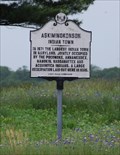 view gallery view galleryN6.3 km |  Askiminokonson Indian Town Askiminokonson Indian Town
in Maryland Historical Markers On the corner of Nassawango Road and Highway 12 (Snow Hill Road), just northwest of Snow Hill, this was once the site of one of the largest Indian towns in Maryland. posted by: 94RedRover location: Maryland date approved: 05/27/2009 last visited: 03/08/2014 |
 view gallery view gallery NW10 km NW10 km
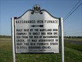
| Nassawango Iron Furnace in Maryland Historical Markers Near Nassawango Iron Furnace posted by: robert location: Maryland date approved: 03/27/2006 last visited: 04/15/2023 |
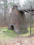 view gallery view galleryNW10.1 km |  Nassawango Iron Furnace Nassawango Iron Furnace
in Iron Furnace Ruins The Nassawango Iron Furnace in Snow Hill, MD produced pig iron between 1832 and 1850. Furnace is in decent condition today, but has not been in use for quite some time. posted by: robert location: Maryland date approved: 03/27/2006 last visited: 08/01/2013 |
 view gallery view gallery S14 km S14 km
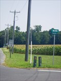
|  Maryland/Virginia Crossing at MD12/VA679 Maryland/Virginia Crossing at MD12/VA679
in Border Crossings Rural crossing between Maryland and Virginia, along a route that serves as a scenic 'short cut' between Berlin/Ocean City and Chincoteague. posted by:  Ernmark Ernmark location: Virginia date approved: 09/25/2012 last visited: 03/22/1994 |
 view gallery view gallery SE16.1 km SE16.1 km
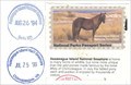
| ") Assateague Island National Seashore Assateague Island National Seashore
in National Parks (U.S.) Assateague's wild horses are well known, even to many people who have never been to the island. The "wild" horses on Assateague are actually feral animals, meaning that they are descendants of domestic animals that have reverted to a wild state. posted by: Don.Morfe location: Maryland date approved: 12/15/2019 last visited: 04/15/2023 |
 view gallery view gallery SW16.4 km SW16.4 km
|  Pocomoke City, MD Fallout Shelter Pocomoke City, MD Fallout Shelter
in Civil Defense Fallout Shelters Fallout shelter located at 207 Market Street, Pocomoke City, MD. posted by: Team Smokey location: Maryland date approved: 07/27/2009 last visited: never |
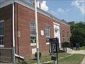
 view gallery view gallerySW16.4 km |  Pocomoke City, MD 21851 Pocomoke City, MD 21851
in U.S. Post Offices Pocomoke City, MD 21851 US Post Office posted by: Team Smokey location: Maryland date approved: 07/27/2009 last visited: never |
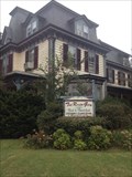
 view gallery view gallerySW16.4 km |  Costen House - Pocomoke City MD Costen House - Pocomoke City MD
in Wikipedia Entries The Costen House is a historic U.S. home located at 206 Market Street, Pocomoke City, Maryland, United States. Dr. Isaac Thomas Costen built the house c. 1870s and members of his family lived there for over a century. posted by: Don.Morfe location: Maryland date approved: 09/23/2021 last visited: 09/23/2021 |
 view gallery view gallerySW16.4 km |  Costen House - Pocomoke City MD Costen House - Pocomoke City MD
in U.S. National Register of Historic Places The Costen House was built by Dr. Isaac Costen shortly after the Civil War and was lived in by members of his family for over a century. posted by: Don.Morfe location: Maryland date approved: 01/05/2021 last visited: 09/23/2021 |
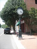 view gallery view gallerySW16.6 km |  Town Clock - Pocomoke City, MD Town Clock - Pocomoke City, MD
in Town Clocks Town Clock - Pocomoke City, MD posted by: Team Smokey location: Maryland date approved: 07/28/2009 last visited: never |
 view gallery view gallery W16.6 km W16.6 km
| 857 1227 TIDAL 4 RESET (HU2663) - Pokomoke City, MD in U.S. Benchmarks Benchmark on pedestal base on bridge pier. posted by: wilsonjw location: Maryland date approved: 09/04/2017 last visited: 06/26/2011 |
 view gallery view gallerySW16.6 km |  The River Gem BnB at The Littleton T. Clarke House -- Pocomoke City, Maryland The River Gem BnB at The Littleton T. Clarke House -- Pocomoke City, Maryland
in Bed and Breakfast River Gem Bed and Breakfast, Pocomoke City, Maryland posted by: wilsonjw location: Maryland date approved: 09/11/2017 last visited: never |
 view gallery view galleryNW19.2 km | MD SHA LUKE 2000, Maryland in U.S. Benchmarks MD SHA LUKE 2000, MD, is a Maryland State Highway Administration survey disk located along State Highway 12 in Worcester County, MD. posted by: seventhings location: Maryland date approved: 11/30/2005 last visited: never |
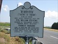 view gallery view galleryW19.3 km | Rehoboth in Maryland Historical Markers Rehoboth - Virginia Historical Marker located on US Rt. 13 posted by: Team Smokey location: Maryland date approved: 08/05/2009 last visited: 12/30/2012 |
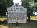 view gallery view gallerySW19.3 km | Boundary Line Maryland - Virginia in Maryland Historical Markers Boundary Line Maryland - Virginia Historical Marker located at the Maryland Welcome Center on US Rt. 13 posted by: Team Smokey location: Maryland date approved: 07/27/2009 last visited: 06/30/2021 |
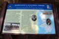 view gallery view gallerySW19.3 km |  Maryland's Eastern Shore-Hundreds of Enslaved and Free Black Men Enlisted-Pocomoke City, MD Maryland's Eastern Shore-Hundreds of Enslaved and Free Black Men Enlisted-Pocomoke City, MD
in Civil War Discovery Trail Sites Located in the Maryland Welcome Center at the Virginia/Maryland State Line on US 13. posted by: Markerman62 location: Maryland date approved: 08/02/2020 last visited: 07/30/2020 |
 view gallery view gallerySW19.3 km |  TIC - US Rte. 13 Eastern Shore Maryland TIC - US Rte. 13 Eastern Shore Maryland
in Tourist Information Centers - Visitor Centers Welcome Center on the Eastern Shore of Maryland. posted by: sfwife location: Maryland date approved: 09/18/2007 last visited: 07/21/2020 |
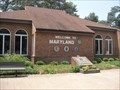 view gallery view gallerySW19.3 km |  Maryland Welcome Center, US Rt. 13 Northbound Maryland Welcome Center, US Rt. 13 Northbound
in Highway Rest Areas Maryland Welcome Center located on US Rt. 13 Northbound posted by: Team Smokey location: Maryland date approved: 07/28/2009 last visited: 12/02/2019 |
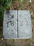 view gallery view gallerySW19.5 km |  Maryland/Virginia Boundary N of Marva RD Near US 13 Maryland/Virginia Boundary N of Marva RD Near US 13
in Public Land Survey Marks Granite Post dating back to an 1883 survey of the MD/VA state line. posted by: Ernmark location: Virginia date approved: 04/04/2013 last visited: 10/05/2019 |
 view gallery view gallerySW19.5 km | BOUNDARY MONUMENT (HU1835/HU0523) - MD/VA in U.S. Benchmarks Stone border monument dating back to 1883. posted by: Ernmark location: Virginia date approved: 09/10/2012 last visited: 10/05/2019 |
 view gallery view gallerySW19.5 km | Virginia - Maryland State Line - Marva Road in Border Crossings VA - MD border located just off US Rt. 13 on Marva Road. posted by: Team Smokey location: Virginia date approved: 07/28/2009 last visited: 10/05/2019 |
 view gallery view gallerySW19.5 km | Maryland/Virginia Border at U.S. 13 in Border Crossings A main highway crossing between MD & VA on the Delmarva Peninsula. posted by: Ernmark location: Virginia date approved: 09/25/2012 last visited: 09/23/2019 |
|