 view gallery view gallery NE41 km NE41 km
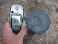
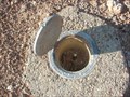
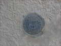
|   Benchmark: JO0456 Benchmark: JO0456
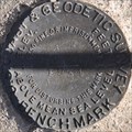
in U.S. Benchmarks We came across this U.S. Geological Survey Disc near the Ghost town of Frisco, Utah. posted by:  JacobBarlow JacobBarlow location: Utah date approved: 09/18/2007 last visited: 10/02/2011 |
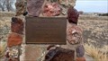
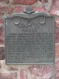 view gallery view galleryNE41.2 km |  Frisco Frisco
in Utah Historical Markers A typical mining town at the foot of the San Francisco mountains was fed by the fabulously rich Horn Silver Mine... posted by: JacobBarlow location: Utah date approved: 09/07/2007 last visited: 03/26/2020 |
 view gallery view galleryNE41.2 km |  Frisco - 268 Frisco - 268
in D.U.P. Historic Markers A typical mining town at the foot of the San Francisco mountains was fed by the fabulously rich Horn Silver Mine. posted by:  Mooroid Mooroid location: Utah date approved: 10/03/2011 last visited: 03/27/2020 |
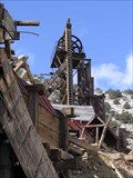 view gallery view galleryNE41.8 km |  Frisco, Utah Frisco, Utah
in Ghost Towns Frisco was founded August 21, 1871 and was abandoned in the early 1920's. The mines produced $80,000,000 in ore, primarily silver and lead, and at one time the city boost a population of 6,000. posted by: maritimedriver location: Utah date approved: 06/28/2006 last visited: 10/03/2011 |
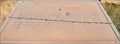
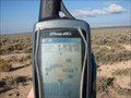 view gallery view gallery E43.9 km E43.9 km
|  N 38° W 113° N 38° W 113°
in Confluence Spots A short ( less than 500 feet ) walk from the highway through the
sagebrush will bring you to this confluence spot. posted by: JacobBarlow location: Utah date approved: 10/17/2007 last visited: 10/23/2016 |
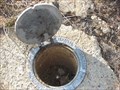
 view gallery view galleryE44.1 km | Benchmark: JO0411 " Q 369 " in U.S. Benchmarks Easy to find, just off the highway. posted by: JacobBarlow location: Utah date approved: 10/19/2007 last visited: 10/23/2016 |
 view gallery view galleryE44.3 km | Benchmark: JO0408 " M 369 " in U.S. Benchmarks Easily found, right off the road. posted by: JacobBarlow location: Utah date approved: 10/19/2007 last visited: 10/20/2007 |
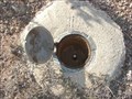 view gallery view galleryE45.2 km | Benchmark: JO0407 " L 369 " in U.S. Benchmarks Found easily, right off the highway. posted by: JacobBarlow location: Utah date approved: 10/19/2007 last visited: 10/20/2007 |
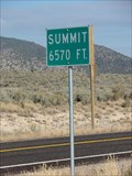 view gallery view galleryE45.5 km |  Summit 6570 HWY 130 Summit 6570 HWY 130
in Elevation Signs The summit along HWY 130 between Cedar City and Minersville, the Elevation is 6,570 feet above Sea Level. posted by: JacobBarlow location: Utah date approved: 11/01/2007 last visited: 09/29/2011 |
 view gallery view galleryE48.3 km | USCGS JO0167 ~ V 32 in U.S. Benchmarks This Benchmark is located on the southwest side of Utah Highway 21, about 5 miles northwest of Minersville at Milepost 87. posted by: brwhiz location: Utah date approved: 03/31/2012 last visited: never |
 view gallery view gallery S48.8 km S48.8 km
|  Pioneer Park - Beryl Junction, UT Pioneer Park - Beryl Junction, UT
in Municipal Parks and Plazas This modest park contains little other than a shelter and a monument - in Beryl Junction, Utah. posted by: The Snowdog location: Utah date approved: 01/01/2023 last visited: never |
 view gallery view gallery SE49.1 km SE49.1 km
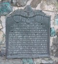
| Parowan Gap Petroglyphs in Utah Historical Markers This older, rather nondescript historical marker is one of two at the petroglyphs in Parowan Gap. posted by: brwhiz location: Utah date approved: 04/07/2012 last visited: 10/22/2019 |
 view gallery view galleryE49.2 km | The Lincoln Mine in Utah Historical Markers "First Lead Mine in Utah" Five miles northeast of Minersville, discovered in 1858 by Isaac Grundy, Jesse N. Smith, Tarlton Lewis, and William Barton... posted by: JacobBarlow location: Utah date approved: 09/07/2007 last visited: 09/29/2011 |
 view gallery view galleryE49.2 km |  The First Lead Mine in Utah The First Lead Mine in Utah
in First of its Kind Five miles northeast of Minersville, discovered in 1858 by Isaac Grundy, Jesse N. Smith, Tarlton Lewis, and William Barton... posted by: JacobBarlow location: Utah date approved: 09/08/2007 last visited: 09/29/2011 |
 view gallery view galleryE49.2 km | The Lincoln Mine - 17 in D.U.P. Historic Markers First Lead Mine in Utah posted by: Mooroid location: Utah date approved: 10/03/2011 last visited: 09/29/2011 |
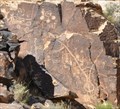 view gallery view gallerySE49.2 km |  Parowan Gap Petroglyphs Parowan Gap Petroglyphs
in Pictographs The Parowan Gap Petroglyphs were officially "discovered" by a group from the Southern Expedition of 1849 under the leadership of David Fullmer. posted by: brwhiz location: Utah date approved: 04/07/2012 last visited: 10/22/2019 |
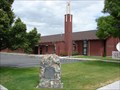
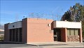
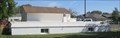
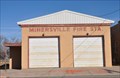 view gallery view galleryE49.2 km |  Minersville Fire Station Minersville Fire Station
in Firehouses This Firehouse is located at 70 W Main Street Street in Minersville, Utah. posted by: brwhiz location: Utah date approved: 05/17/2013 last visited: never |
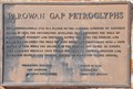
 view gallery view gallerySE49.2 km | Parowan Gap Petroglyphs - Eagle Scout Marker in Utah Historical Markers An Eagle Scout Project has provided a nice historical marker for these interesting pictographs. posted by: brwhiz location: Utah date approved: 04/08/2012 last visited: 10/22/2019 |
 view gallery view gallerySE49.2 km |  Parowan Gap Petroglyphs Marker Parowan Gap Petroglyphs Marker
in Eagle Scout Project Sites Eagle Scout Alva Metheson has provided a nice historical marker for the interesting pictographs at Parowan Gap. posted by: brwhiz location: Utah date approved: 04/08/2012 last visited: 10/20/2019 |
 view gallery view galleryE49.2 km |  Minersville Public Library Minersville Public Library
in Libraries This Library is located at 40 W Center Street in Minersville, Utah. posted by: brwhiz location: Utah date approved: 05/18/2013 last visited: never |
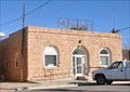 view gallery view galleryE49.4 km |  Minersville, Utah Minersville, Utah
in City and Town Halls This City Hall is located at 60 W Main Street in Minersville, Utah. posted by: brwhiz location: Utah date approved: 05/19/2013 last visited: never |
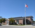 view gallery view galleryE49.4 km |  Minersville, Utah 84752 Minersville, Utah 84752
in U.S. Post Offices This Post Office is located at 51 N Center Street in Minersville, Utah. posted by: brwhiz location: Utah date approved: 11/09/2011 last visited: 01/13/2012 |
 view gallery view galleryNE50.4 km | Benchmark: JO0326 " B 183 " in U.S. Benchmarks In the west side of the building, near the north corner. posted by: JacobBarlow location: Utah date approved: 10/19/2007 last visited: 10/02/2011 |
 view gallery view galleryNE50.4 km |  Basement House - Milford, UT Basement House - Milford, UT
in Earth Homes This basement house emerges only three feet above the ground. posted by: rjmcdonough1 location: Utah date approved: 09/09/2019 last visited: never |
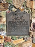 view gallery view galleryE50.4 km | The Grist Mill in Utah Historical Markers Minersville was settled in 1859 for the purpose of opening lead mines. Nelson S. Hollingshead built a grist mill on this site in 1871. It was operated by water diverted from the Minersville canal.... posted by: JacobBarlow location: Utah date approved: 10/25/2007 last visited: 01/13/2012 |
|