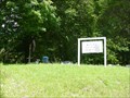
 view gallery view gallery SW0.3 km SW0.3 km
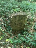
|   Lower Salt Lick Cemetery - Salt Lick, KY, US Lower Salt Lick Cemetery - Salt Lick, KY, US
in Worldwide Cemeteries Located on South Hwy 211. Cemetery is approximately 1.5 miles. Turn right on small gravel road just before little blue house. posted by:  Crazy4horses Crazy4horses location: Kentucky date approved: 12/20/2016 last visited: 12/20/2016 |
 view gallery view gallery N2.1 km N2.1 km
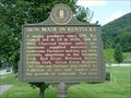
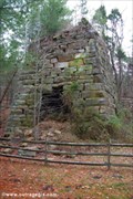
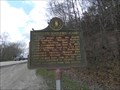
|  Iron Made in Kentucky Iron Made in Kentucky
in Kentucky Historical Markers One side of this marker provides a brief history of iron making in Kentucky. The other side provides a history of nearby Clear Creek Furnace which is also a waymark. posted by: Simplenfun location: Kentucky date approved: 08/11/2011 last visited: 10/11/2016 |
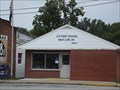 view gallery view galleryN2.4 km |  Salt Lick, Kentucky, 40371 Salt Lick, Kentucky, 40371
in U.S. Post Offices Salt Lick is a city in Bath County, Kentucky, United States. The population was 342 at the 2000 census. posted by: Simplenfun location: Kentucky date approved: 08/21/2011 last visited: 10/11/2016 |
 view gallery view gallery E3.4 km E3.4 km
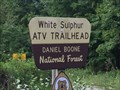
|  White Sulphur ATV Trial - Salt Lick, KY, US White Sulphur ATV Trial - Salt Lick, KY, US
in Offroad Trails From I-64 East, take exit 123. Travel east on KY 60 and turn right on KY 211 to Salt Lick.
From KY 211, turn left onto Forest Service Road 129. Just past the Clear Creek Country Store, turn left onto Forest Service Road 105 posted by: Crazy4horses location: Kentucky date approved: 08/03/2016 last visited: 10/10/2016 |
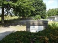
 view gallery view gallery SE3.9 km SE3.9 km
| White Sulphur Cemetery in Worldwide Cemeteries This is a very small cemetery located near Salt Lick, Kentucky, USA. There are approximately 25 graves here. posted by: Simplenfun location: Kentucky date approved: 08/15/2011 last visited: 10/11/2016 |
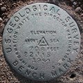 view gallery view gallery NW5.1 km NW5.1 km
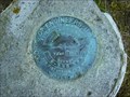
|  USGS 22 JJS 708 1951, Bath County, KY USGS 22 JJS 708 1951, Bath County, KY
in U.S. Benchmarks About 25 feet south of US-60, west of the church parking lot. The post is leaning about 30 degrees north, projects about 1 foot and might have been moved. posted by:  wuja wuja location: Kentucky date approved: 11/19/2007 last visited: never |
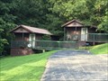
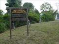
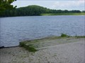 view gallery view gallerySE5.3 km |  Clear Creek Lake Boat Ramp Clear Creek Lake Boat Ramp
in Boat Ramps Clear Creek Lake is 40 acres with only electric motors allowed. The ramp is open year-round 24 hours. posted by: Simplenfun location: Kentucky date approved: 08/14/2011 last visited: 10/11/2016 |
 view gallery view gallery NE5.6 km NE5.6 km
| Jones Cemetery - Salt Lick, KY, USA in Worldwide Cemeteries This is a rural cemetery with approximately 1200 graves located in a community known as Midland. posted by: Simplenfun location: Kentucky date approved: 08/18/2011 last visited: 10/11/2016 |
 view gallery view galleryNE5.6 km | Bath County Memorial Gardens in Worldwide Cemeteries Located off of US 60 on Old River Road posted by: Simplenfun location: Kentucky date approved: 10/11/2016 last visited: 12/21/2016 |
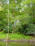
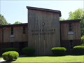
 view gallery view gallerySE6.1 km |  Clear Creek Furnace, Kentucky Clear Creek Furnace, Kentucky
in Ovens and Kilns This is one of several old iron furnaces in Kentucky. posted by: Simplenfun location: Kentucky date approved: 08/10/2008 last visited: 10/11/2016 |
 view gallery view galleryE7.1 km |  Licking River Gage at Cave Run Lake Tailwater Licking River Gage at Cave Run Lake Tailwater
in River Gauges This gauge on the Licking River is located just below the tailwater area of Cave Run Lake. posted by: Simplenfun location: Kentucky date approved: 09/11/2011 last visited: 10/11/2016 |
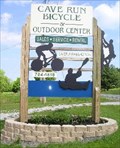 view gallery view galleryNE7.2 km |  Cave Run Bicycle and Outdoor Center Cave Run Bicycle and Outdoor Center
in Outdoor Recreation Stores Cave Run Bicycle and Outdoor Center is a full service shop. posted by: bdpalace location: Kentucky date approved: 05/17/2007 last visited: 08/09/2016 |
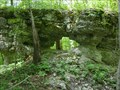 view gallery view gallerySE7.2 km |  Zilpo Arch, DBNF Kentucky Zilpo Arch, DBNF Kentucky
in Natural Arches Zilpo Arch is a small arch located in the Daniel Boone National Forest, and easily accessible from the road where there is a pulloff area for parking. posted by: Simplenfun location: Kentucky date approved: 09/12/2011 last visited: 10/11/2016 |
 view gallery view galleryE7.4 km |  Cave Run Cabins - Farmers, KY, US Cave Run Cabins - Farmers, KY, US
in Chalet, Cottage, and Cabin Style Lodging Located just a half mile from the Daniel Boone National Forest and Cave Run Lake, off KY-801 south off of US 60. posted by: Crazy4horses location: Kentucky date approved: 08/08/2016 last visited: 10/10/2016 |
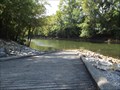 view gallery view galleryE7.4 km | Cave Run Lake Tailwater Boat Ramp in Boat Ramps This boat ramp in the tailwater area of Cave Run Lake provides easy access to the Licking River below the dam. posted by: Simplenfun location: Kentucky date approved: 09/05/2011 last visited: 10/11/2016 |
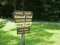 view gallery view gallerySE7.6 km |  Clear Creek Shooting Range Clear Creek Shooting Range
in Shooting Ranges The Clear Creek Shooting Range is an outdoor range located in the Daniel Boone National Forest, and operated by the U.S. Forest Service. It is one of the four shooting ranges on the Daniel Boone National Forest. All ranges are open year round. posted by: Simplenfun location: Kentucky date approved: 08/10/2011 last visited: 10/11/2016 |
 view gallery view galleryE7.6 km |  Minor E. Clark Fish Hatchery - Morehead, KY, USA Minor E. Clark Fish Hatchery - Morehead, KY, USA
in Fish Hatcheries Below Cave Run Lake dam is the Minor E. Clark Fish Hatchery, operated by the Kentucky Department of Fish and Wildlife Resources. posted by: Simplenfun location: Kentucky date approved: 08/28/2011 last visited: 10/11/2016 |
 view gallery view galleryNE7.9 km | Kentucky Historical Marker No. 567 in Kentucky Historical Markers During the final Kentucky raid, Morgan's Raiders camped here in 1864. posted by: Simplenfun location: Kentucky date approved: 04/05/2011 last visited: 10/11/2016 |
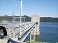 view gallery view galleryE7.9 km |  Cave Run Lake Dam - Farmers, Kentucky Cave Run Lake Dam - Farmers, Kentucky
in Water Dams Cave Run Lake was created by the construction of an earth and rock-fill dam across the Licking River. posted by: Simplenfun location: Kentucky date approved: 08/29/2011 last visited: 10/11/2016 |
 view gallery view galleryNE8 km | Ingram Stevens Cemetery est. 1884 - Farmers, KY, USA in Worldwide Cemeteries Very small well-kept roadside cemetery located in Farmers, KY! posted by: Simplenfun location: Kentucky date approved: 09/01/2011 last visited: 10/11/2016 |
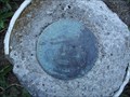 view gallery view galleryE8 km | Cave Run Lake Reset in U.S. Benchmarks Reset disk located on North Rowan County end of Cave Run Lake dam. posted by: Simplenfun location: Kentucky date approved: 08/28/2011 last visited: 10/11/2016 |
 view gallery view galleryE8 km |  Cave Run Lake Scenic Overlook Cave Run Lake Scenic Overlook
in Scenic Overlooks One of the beautiful views of Cave Run Lake! posted by: Simplenfun location: Kentucky date approved: 08/29/2011 last visited: 10/11/2016 |
 view gallery view galleryE8 km | Cave Run Lake Scenic Overlook Survey Mark in U.S. Benchmarks Disk located near scenic viewing area of Cave Run Lake. posted by: Simplenfun location: Kentucky date approved: 08/28/2011 last visited: 10/11/2016 |
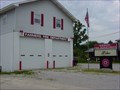 view gallery view galleryNE8 km |  Farmers Fire Department Farmers Fire Department
in Firehouses This fire department operates out of 2 stations that protect a primarily rural area of 34 1/2 square miles with a population of around 4000 people. posted by: Simplenfun location: Kentucky date approved: 10/25/2016 last visited: 10/26/2016 |
 view gallery view gallerySE8.2 km |  Bath County High Point, KY, US Bath County High Point, KY, US
in Geographic High Points Located in Daniel Boone Nation Forest on Zilpo Scenic Drive. posted by: Crazy4horses location: Kentucky date approved: 01/04/2017 last visited: 01/04/2017 |
|