 view gallery view gallery NW15.1 km NW15.1 km
|   Al Larsen - Matfield Green Rest Area - Rural Chase County, Ks. Al Larsen - Matfield Green Rest Area - Rural Chase County, Ks.
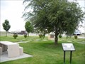
in Citizen Memorials This very moving memorial is located north of the service area in the Matfield Green Service Area at Mile Post 96 on the Kansas Turnpike. posted by:  iconions iconions location: Kansas date approved: 07/09/2011 last visited: 04/29/2022 |
 view gallery view gallery W15.1 km W15.1 km
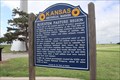
|  The Bluestem Pasture Region of Kansas - Rural Butler County, Ks. The Bluestem Pasture Region of Kansas - Rural Butler County, Ks.
in Kansas Historical Markers This marker is in the Matfield Green Rest Area at Milepost 96 along the Kansas Turnpike in rural Butler County, Kansas. posted by: iconions location: Kansas date approved: 07/10/2011 last visited: 04/29/2022 |
 view gallery view galleryW15.1 km |  The Bluestem Pasture Region of KS -- Matfield Green KTA Service Area, Towanda KS The Bluestem Pasture Region of KS -- Matfield Green KTA Service Area, Towanda KS
in Flora and Fauna Information Signs A flora and fauna information sign at the Matfield Green KTA Service Area, Towanda KS posted by: Benchmark Blasterz location: Kansas date approved: 11/28/2017 last visited: 04/29/2022 |
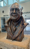 view gallery view galleryNW15.1 km |  Knute Rockne - Matfield Green, KS Knute Rockne - Matfield Green, KS
in Statues of Historic Figures This bust of Knute Rockne is at the center of the Manfield Green Service Area - near Manfield Green, Kansas. posted by: The Snowdog location: Kansas date approved: 04/28/2022 last visited: never |
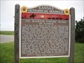
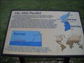 view gallery view galleryW15.1 km |  38th Parallel - Matfield Green Rest Area - Rural Butler County, Ks. 38th Parallel - Matfield Green Rest Area - Rural Butler County, Ks.
in Korean War Memorials This historical marker in the Matfield Green Rest Area describes the 38th parallel going through Kansas and Korea. It then also describes the Korean Conflict and the Kansas National Guard Units mobilized. posted by: iconions location: Kansas date approved: 07/09/2011 last visited: 04/29/2022 |
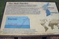 view gallery view galleryW15.1 km |  38th Parallel -- KTA Service Area, Towanda KS 38th Parallel -- KTA Service Area, Towanda KS
in Great Lines of Earth A sign at the KTA Service Area, Towanda KS near the 38th parallel of Earth, which passes near here. The 38th parallel is important because it is the border between North and South Korea posted by: Benchmark Blasterz location: Kansas date approved: 11/28/2017 last visited: 04/29/2022 |
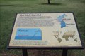 view gallery view galleryW15.1 km | 38th Parallel -- Matfield Green KTA Service Area, Towanda KS in Kansas Historical Markers A sign at the KTA Matfield Green Service Area near the 38th parallel of Earth, which passes near here, memorializes the Korean War and the Kansas ARNG units that were delpoyed to fight there posted by: Benchmark Blasterz location: Kansas date approved: 11/27/2017 last visited: 04/29/2022 |
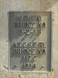 view gallery view galleryNW17.5 km |  Highway/A.T.&S.F. Ry. Bridge - 1936 ~ Matfield Green KS Highway/A.T.&S.F. Ry. Bridge - 1936 ~ Matfield Green KS
in Bridge Date Stones and Plaques This Bridge Date Plaque is on A.T & S.F.RY. Bridge No. 147 C that crosses Kansas Highway 177, 3.25 miles south of Matfield Green, Kansas. posted by: PeterNoG location: Kansas date approved: 06/18/2014 last visited: 03/03/2011 |
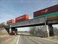 view gallery view galleryNW17.5 km |  A.T.&S.F. Ry. Bridge - Matfield Green KS A.T.&S.F. Ry. Bridge - Matfield Green KS
in Railroad Bridges This Railroad Bridge is A.T & S.F.RY. Bridge No. 147 C that crosses Kansas Highway 177, 3.25 miles south of Matfield Green, Kansas. posted by: PeterNoG location: Kansas date approved: 06/18/2014 last visited: 03/03/2011 |
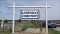 view gallery view galleryW20.8 km |  Cassoday Cemetery - Cassoday, KS Cassoday Cemetery - Cassoday, KS
in Worldwide Cemeteries Cassoday Cemetery is about a mile west of Cassoday, Kansas. posted by: The Snowdog location: Kansas date approved: 04/24/2023 last visited: never |
 view gallery view gallery N20.9 km N20.9 km
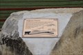
| Tallgrass Prairie -- KTA scenic pull-out, southwest of Emporia, KS in Flora and Fauna Information Signs This flora and fauna sign is located in the scenic pullout along the KTA southwest of Emporia KS posted by: Benchmark Blasterz location: Kansas date approved: 11/29/2017 last visited: 08/21/2017 |
 view gallery view galleryN20.9 km |  Flint Hills Scenic Pull-out -- KTA MM 111, SW of Emporia KS Flint Hills Scenic Pull-out -- KTA MM 111, SW of Emporia KS
in Scenic Roadside Look-Outs A beautiful spot to see the Tallgrass Prairie from the scenic pullout along the KTA at mile marker 111 southwest of Emporia KS posted by: Benchmark Blasterz location: Kansas date approved: 12/09/2017 last visited: 08/20/2017 |
 view gallery view galleryN20.9 km | Tallgrass Prairie -- KTA scenic pull-out, southwest of Emporia, KS in Kansas Historical Markers This marker is located in the scenic pullout alomg the KTA southwest of Emporia KS posted by: Benchmark Blasterz location: Kansas date approved: 11/29/2017 last visited: 08/21/2017 |
 view gallery view galleryN26.2 km |  BAZAAR - Bazaar, KS BAZAAR - Bazaar, KS
in Letters on Hills The name of this small town is spelled out in large letters - on a hillside southeast of Bazaar, Kansas. posted by: The Snowdog location: Kansas date approved: 04/24/2023 last visited: never |
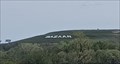 view gallery view galleryN26.2 km |  BAZAAR - Bazaar, KS BAZAAR - Bazaar, KS
in Readable From Above The name of this small town is spelled out in large letters - on a hillside southeast of Bazaar, Kansas. posted by: The Snowdog location: Kansas date approved: 04/25/2023 last visited: never |
 view gallery view galleryNW27.7 km | Bazaar Cemetery - Bazaar, KS in Worldwide Cemeteries Bazaar Cemetery is just west of the town of Bazaar, Kansas. posted by: The Snowdog location: Kansas date approved: 04/24/2023 last visited: never |
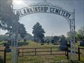 view gallery view gallery SW34.1 km SW34.1 km
| Blankenship Cemetery - Rosalia, KS in Worldwide Cemeteries This small cemetery is in northeast Butler County, a few miles south of Rosalia, Kansas. posted by: The Snowdog location: Kansas date approved: 05/11/2023 last visited: never |
 view gallery view gallerySW34.1 km |  Butler County Fural Fire District #5 Butler County Fural Fire District #5
in Firehouses This small firehouse is on the west side of Flint Hills Road, a few miles south of Rosalita, Kansas. posted by: The Snowdog location: Kansas date approved: 05/11/2023 last visited: never |
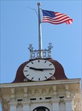 view gallery view galleryN38 km |  Chase County Courthouse Clock - Cottonwood Falls, Kansas Chase County Courthouse Clock - Cottonwood Falls, Kansas
in Town Clocks Clock mounted atop the historic courthouse in Cottonwood Falls, Kansas. posted by:  BruceS BruceS location: Kansas date approved: 05/01/2011 last visited: 07/25/2008 |
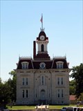 view gallery view galleryN38 km |  Chase County Courthouse - Cottonwood Falls, Kansas Chase County Courthouse - Cottonwood Falls, Kansas
in U.S. National Register of Historic Places Historic and now the oldest county courthouse in Kansas. posted by: BruceS location: Kansas date approved: 05/01/2011 last visited: 07/25/2008 |
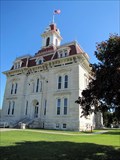 view gallery view galleryN38 km |  Chase County Courthouse - Cottonwood Falls, Kansas Chase County Courthouse - Cottonwood Falls, Kansas
in Wikipedia Entries Historic and now the oldest county courthouse in Kansas. posted by: BruceS location: Kansas date approved: 05/01/2011 last visited: 07/25/2008 |
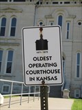 view gallery view galleryN38 km |  OLDEST - Operating Courthouse In Kansas OLDEST - Operating Courthouse In Kansas
in Superlatives The Chase County Courthouse in Cottonwood Falls is the oldest county courthouse in Kansas. posted by: BruceS location: Kansas date approved: 05/01/2011 last visited: 07/25/2008 |
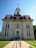 view gallery view galleryN38 km |  Chase County Courthouse - Cottonwood Falls, Kansas Chase County Courthouse - Cottonwood Falls, Kansas
in Courthouses Historic and now the oldest county courthouse in Kansas. posted by: BruceS location: Kansas date approved: 05/19/2011 last visited: 07/25/2008 |
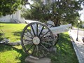 view gallery view galleryN38 km |  Japanese Cannon - Cottonwood Falls, Kansas Japanese Cannon - Cottonwood Falls, Kansas
in Static Artillery Displays Japanese cannon on the grounds of the Chase County Courthouse in Cottonwood Falls, Kansas. posted by: BruceS location: Kansas date approved: 05/08/2011 last visited: 07/25/2008 |
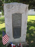 view gallery view galleryN38 km |  Chase County World War I Memorial - Cottonwood Falls, Kansas Chase County World War I Memorial - Cottonwood Falls, Kansas
in World War I Memorials and Monuments World War I memorial on the grounds of the Chase County Courthouse in Cottonwood Falls, Kansas. posted by: BruceS location: Kansas date approved: 05/02/2011 last visited: 07/25/2008 |
|