 view gallery view gallery S2.3 km S2.3 km
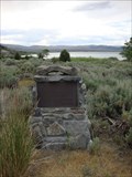
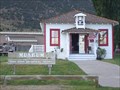
|   American Legion - Mono City, CA American Legion - Mono City, CA
in Veteran Cemeteries American Legion cemetery is located in Mono Lake, CA. posted by:  tatie tatie location: California date approved: 10/22/2013 last visited: 10/30/2018 |
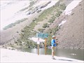
 view gallery view gallery NW4.7 km NW4.7 km
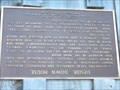
|  Mono Diggins - Mono Lake, CA Mono Diggins - Mono Lake, CA
in E Clampus Vitus Historical Markers Awesome view off of 395. posted by: bluesnote location: California date approved: 05/20/2010 last visited: 05/31/2012 |
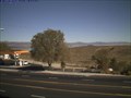
 view gallery view galleryNW4.7 km |  Mono Diggins - Mono Lake, CA Mono Diggins - Mono Lake, CA
in Scenic Roadside Look-Outs Awesome view off of 395. posted by: bluesnote location: California date approved: 04/21/2016 last visited: 06/22/2018 |
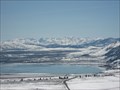 view gallery view galleryNW4.7 km |  Mono Diggins - Mono Lake, CA Mono Diggins - Mono Lake, CA
in Scenic Overlooks An AMAZING view of Mono Lake. posted by: bluesnote location: California date approved: 10/05/2010 last visited: 10/03/2015 |
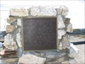
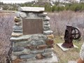
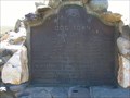
 view gallery view galleryS7.2 km | Sheriff James P. Dolan in E Clampus Vitus Historical Markers Located at the Mono Lake Tufa State Natural Reserve. Found this while visiting the tufa. The marker is at the entrance to the parking lot of the picnic area. posted by: fresgo location: California date approved: 07/13/2010 last visited: 10/30/2018 |
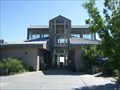 view gallery view galleryS8.5 km |  Mono Basin Visitor Center - Lee Vining, CA Mono Basin Visitor Center - Lee Vining, CA
in Ranger Stations This big center have info on Mono Lake and the surrounding area. It's located on highway 395 just outside of Lee Vining. posted by: Free2bme29 location: California date approved: 07/24/2009 last visited: 10/30/2018 |
 view gallery view galleryS8.5 km |  Gardening for birds and butterflies - Mono Basin, CA Gardening for birds and butterflies - Mono Basin, CA
in Butterfly Gardens Gardening for birds and butterflies is located in Mono Lake, CA. posted by: tatie location: California date approved: 10/21/2013 last visited: 03/02/2014 |
 view gallery view galleryS9.3 km |  The Old School House Museum - Lee Vining, CA The Old School House Museum - Lee Vining, CA
in History Museums Located in Mono Lake's Old School House, this museum displays both the commonplace and delightfully odd artifacts, photographs, books, maps and equipment chronicling the cultural history of the Mono Basin. posted by:  FindersKeepersLTD FindersKeepersLTD location: California date approved: 09/02/2008 last visited: 06/30/2012 |
 view gallery view galleryS9.3 km | Upside - Down House in E Clampus Vitus Historical Markers A house built upside down, from outside structure to inside furnishings. Inspired by children's books. Marker is in Lee Vining, California, 93541 in Mono County. posted by: FindersKeepersLTD location: California date approved: 09/05/2008 last visited: 02/14/2014 |
 view gallery view galleryS9.7 km |  Lee Vining Webcam Lee Vining Webcam
in Web Cameras Easy Webcam Cache. Beautiful view. Photo updates every 5 minutes. posted by: XB70man location: California date approved: 10/09/2008 last visited: 12/27/2008 |
 view gallery view galleryS9.7 km |  LV for Lee Vining LV for Lee Vining
in Letters on Hills The 'LV' representing the town of Lee Vining is located on a hillside on the west side of central Lee Vining, California. posted by: brwhiz location: California date approved: 02/25/2013 last visited: 10/30/2018 |
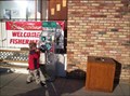 view gallery view galleryS9.7 km |  Lee Vining (Gone) Lee Vining (Gone)
in Penny Smashers This penny smasher is outside the local breakfast restaraunt of Niceley's in the small little town of Lee Vining on the East side of the Sierra Nevada Range. posted by: Touchstone location: California date approved: 09/05/2005 last visited: 08/13/2012 |
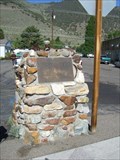 view gallery view galleryS9.7 km | Lee Vining - CA in E Clampus Vitus Historical Markers This marker describes the naming of the community of Lee Vining. posted by: Free2bme29 location: California date approved: 07/15/2009 last visited: 07/04/2012 |
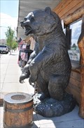 view gallery view galleryS9.7 km |  Bronze Bear Outpost Grizzly Bronze Bear Outpost Grizzly
in Bear Statues This life-size bronze statue of a grizzly bear standing vertically is located in front of the Bronze Bear Outpost at 51321 US Highway 395 in Lee Vining, California. posted by: brwhiz location: California date approved: 02/25/2013 last visited: 02/14/2014 |
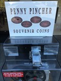 view gallery view galleryS10.8 km | Whoa Nellie Deli, Lee Vining in Penny Smashers Four design penny smasher at the Whoa Nellie Deli (Mobil) in Lee Vining posted by: kablooey location: California date approved: 08/01/2015 last visited: never |
 view gallery view gallery SW13.2 km SW13.2 km
|  The Tioga Pass Road - Lee Vining CA- Elevation 9945' The Tioga Pass Road - Lee Vining CA- Elevation 9945'
in Elevation Signs The Tioga Pass Road Constructed 1883 & 1910. Tioga Pass at 9945 feet is the highest automobile pass in California. The road to the pass was constructed in two parts. posted by: Don.Morfe location: California date approved: 08/10/2020 last visited: 10/30/2021 |
 view gallery view gallerySW14 km | Yosemite - Ellery Lake in Elevation Signs Ellery Lake at the Tioga Pass near the east entrance of Yosemite. posted by: eveningrose location: California date approved: 08/15/2010 last visited: 05/14/2013 |
 view gallery view gallerySW14.6 km | Bennettville - Yosemite NP, California in E Clampus Vitus Historical Markers Reason why the Tioga Road was built posted by: jimnade location: California date approved: 06/13/2015 last visited: never |
 view gallery view gallery SE15 km SE15 km
|  Mono Lake - Mono City, CA Mono Lake - Mono City, CA
in Satellite Imagery Oddities A large salt water lake located in eastern California. posted by: bluesnote location: California date approved: 04/05/2021 last visited: 04/05/2021 |
 view gallery view gallerySE15 km |  Mono Lake - Mono County, California Mono Lake - Mono County, California
in Natural Lakes Mono Lake is an endorheic lake in a geologically active area of eastern California. posted by: shadow101 location: California date approved: 06/20/2012 last visited: 04/04/2010 |
 view gallery view gallerySE15 km |  Mono Lake - Mono City, CA Mono Lake - Mono City, CA
in Wikipedia Entries A large salt water lake located in eastern California. posted by: bluesnote location: California date approved: 03/26/2021 last visited: 03/26/2021 |
 view gallery view gallerySE15 km |  Mono Lake - Mono City, CA Mono Lake - Mono City, CA
in Official Local Tourism Attractions A large salt water lake located in eastern California. posted by: bluesnote location: California date approved: 03/26/2021 last visited: 03/26/2021 |
 view gallery view gallery N15 km N15 km
|  Dog Town Dog Town
in California Historical Markers California Historical Landmark #792 is located on Highway 395. posted by: Free2bme29 location: California date approved: 11/01/2009 last visited: 09/14/2021 |
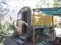 view gallery view galleryN17.1 km |  Virginia Creek Settlement Wagon - Bridgeport, CA Virginia Creek Settlement Wagon - Bridgeport, CA
in Covered Wagons A covered wagon for rent! posted by: chrissyml location: California date approved: 07/09/2012 last visited: never |
 view gallery view gallerySW17.5 km |  Mount Conness Mount Conness
in Summit Registers At 12,590 feet, Mount Conness is the tallest peak in the Sierra Nevada North of Tioga Pass. posted by: Touchstone location: California date approved: 08/22/2007 last visited: never |
|