 view gallery view gallery SE4.3 km SE4.3 km
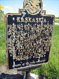
|   Kaskaskia - Ellis Grove, IL Kaskaskia - Ellis Grove, IL
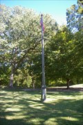
in Illinois Historical Markers Second settlement in Illinois, The Territorial Capital and First State Capital posted by:  kodiak_62 kodiak_62 location: Illinois date approved: 08/21/2008 last visited: 08/23/2008 |
 view gallery view gallery S4.3 km S4.3 km
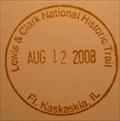
|  Lewis & Clark National Historic Trail - Ft. Kaskaskia, IL Lewis & Clark National Historic Trail - Ft. Kaskaskia, IL
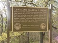
in NPS Passport Cancellation Stations Between May 1804 and September 1806, 31 men, one woman, and a baby traveled from the plains of the Midwest to the shores of the Pacific Ocean. They called themselves the Corps of Discovery. In their search for a water route to the Pacific Ocean, they opened a window onto the west for the young United States. posted by: nomadwillie location: Illinois date approved: 10/30/2008 last visited: 08/19/2005 |
 view gallery view galleryS4.5 km | ") Lewis and Clark NHT - Fort Kaskaskia, IL Lewis and Clark NHT - Fort Kaskaskia, IL
in National Parks (U.S.) Between May 1804 and September 1806, 31 men, one woman, and a baby traveled from the plains of the Midwest to the shores of the Pacific Ocean posted by: nomadwillie location: Illinois date approved: 02/10/2009 last visited: 09/17/2011 |
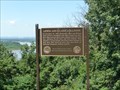
 view gallery view galleryS4.5 km |  A Vanished Capital - near Chester IL A Vanished Capital - near Chester IL
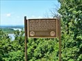
in Scenic Roadside Look-Outs A Vanished Capital, view of the location of Illinois 1st State Capital, Kaskakia. posted by: kJfishman location: Illinois date approved: 10/03/2011 last visited: 10/01/2011 |
 view gallery view galleryS4.5 km |  Lewis and Clark in Illinois - Fort Kaskaskia, Illinois Lewis and Clark in Illinois - Fort Kaskaskia, Illinois
in Lewis and Clark Trail Lewis and Clark visited here during preparations before departing west. posted by: paulspaper location: Illinois date approved: 08/28/2007 last visited: 05/20/2011 |
 view gallery view galleryS4.5 km | Lewis and Clark in Illinois - Ellis Grove, IL in Illinois Historical Markers Located at Fort Kaskaskia right outside the pavillion overlooking the Mississippi River posted by: nomadwillie location: Illinois date approved: 02/24/2013 last visited: never |
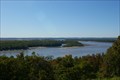
 S4.5 km |  To a Sunken City To a Sunken City
in Weird Story Locations A city sunken, and a state divided by a possible indian curse... posted by:  rockey_f_squirrell rockey_f_squirrell location: Illinois date approved: 08/18/2005 last visited: 06/18/2011 |
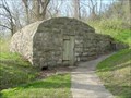 view gallery view galleryS4.8 km |  Pierre Menard Home Spring House Pierre Menard Home Spring House
in Spring Houses Nice spring house made of stone. posted by: paulspaper location: Illinois date approved: 08/20/2007 last visited: 09/05/2010 |
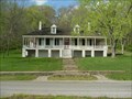 view gallery view galleryS5 km |  Menard, Pierre, House - Ellis Grove, Illinois Menard, Pierre, House - Ellis Grove, Illinois
in U.S. National Register of Historic Places This French Creole style house was the home of Illinois' First Lt Governor, Pierre Menard. posted by: paulspaper location: Illinois date approved: 05/04/2008 last visited: never |
 view gallery view galleryS5 km |  Fort Kaskaskia near Chester IL Fort Kaskaskia near Chester IL
in Military Installations Fort Kaskaskia construction began in 1759 due to the fear of British invasion into what was French territory at the time. posted by: kJfishman location: Illinois date approved: 10/03/2011 last visited: 10/01/2011 |
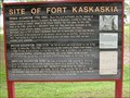 view gallery view galleryS5 km | Site of Fort Kaskaskia - Ellis Grove, IL in Illinois Historical Markers Marker describing the origins of the earthwork remnants of temporary fortifications intended to protect the southern flank of France's colony in Illinois, built on a commanding view of the Mississippi. Now a state historic site. posted by: adgorn location: Illinois date approved: 10/17/2011 last visited: never |
 view gallery view gallery NW5.5 km NW5.5 km
| The American Bottom in Illinois Historical Markers Historical marker describing the rich soil and history of the area.
posted by: paulspaper location: Illinois date approved: 08/27/2007 last visited: 03/28/2014 |
 view gallery view gallery W8.4 km W8.4 km
|  N 38 W 90 - Near Flinton, IL N 38 W 90 - Near Flinton, IL
in Confluence Spots This confluence point lies in the Mississippi River floodplain of Southern Illinois. Near Chester, IL and Sainte Genevieve, MO posted by: Cap'n YB location: Illinois date approved: 12/22/2007 last visited: 12/19/2007 |
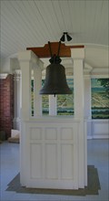 view gallery view galleryS9.7 km |  Liberty Bell Of the West Liberty Bell Of the West
in Bells Liberty Bell of the West - Kaskaskia Island Illinouis posted by: kJfishman location: Illinois date approved: 10/03/2011 last visited: 03/20/2015 |
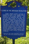 view gallery view galleryS9.7 km |  Illinois in the American Revolution - Kaskaskia Island IL Illinois in the American Revolution - Kaskaskia Island IL
in Spirit of '76 July 1778 was erected by the Illinois Bicentennial Commission and Illinois Historical Society in 1976 on Kaskaskia Island. posted by: kJfishman location: Illinois date approved: 07/28/2012 last visited: 10/27/2013 |
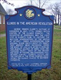 view gallery view galleryS9.7 km | Illinois in the American Revolution in Illinois Historical Markers Possibly the only marker in this category that's west of the Mississippi, it commemorates a small part of the Revolutionary War that took place in Illinois. posted by: Corp Of Discovery location: Illinois date approved: 12/23/2007 last visited: 10/01/2011 |
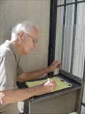 view gallery view galleryS9.8 km |  Kaskaskia Bell Historic Memorial Guestbook - Kaskaskia Island, Illinois Kaskaskia Bell Historic Memorial Guestbook - Kaskaskia Island, Illinois
in Guest Books Guestbook at the Kaskaskia Bell Historic Memorial on Kaskaskia, Island. posted by: paulspaper location: Illinois date approved: 04/05/2008 last visited: 10/27/2013 |
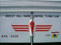 view gallery view gallerySE10.5 km |  Breezy Hill R/C Flying Field Breezy Hill R/C Flying Field
in Model Aircraft Fields The Breezy Hill R/C Flying Field is located on the north end of Chester, IL, across Route 3 from the Cohen Sports Complex. posted by: Monk-E Arms location: Illinois date approved: 02/17/2014 last visited: never |
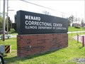 view gallery view gallerySE11.9 km |  Menard Branch of the State Penitentiary - Chester, Illinois Menard Branch of the State Penitentiary - Chester, Illinois
in American Guide Series Maximum security prison in southern Illinois adjacent to Chester. posted by:  BruceS BruceS location: Illinois date approved: 05/03/2009 last visited: 09/17/2011 |
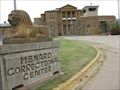 view gallery view gallerySE12.2 km |  Menard Correctional Center Lions - Menard, IL Menard Correctional Center Lions - Menard, IL
in Lion Statues A pair of carved lions scaring people away at the south entrance to the prison. posted by: adgorn location: Illinois date approved: 10/17/2011 last visited: never |
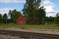 view gallery view galleryW12.2 km |  St. Genevieve Freight Depot - St Genevieve MO St. Genevieve Freight Depot - St Genevieve MO
in Train Stations/Depots The 1910 Ste. Genevieve Freight Depot was on the St. Louis and San Francisco Rail lines. this building is listed in the National register of Historic places. posted by: kJfishman location: Missouri date approved: 09/13/2015 last visited: never |
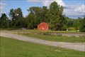 view gallery view galleryW12.2 km |  Ste. Genevieve Freight Depot - Ste. Genevieve Historic District - Ste Genevieve MO Ste. Genevieve Freight Depot - Ste. Genevieve Historic District - Ste Genevieve MO
in NRHP Historic Districts - Contributing Buildings 1910 Ste. Genevieve Freight Depot was on the St. Louis and San Francisco Rail lines. posted by: kJfishman location: Missouri date approved: 01/31/2017 last visited: never |
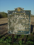
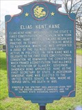 view gallery view gallerySE12.4 km | Elias Kent Kane in Illinois Historical Markers Historical marker for the first Secretary of State for Illinois. posted by: paulspaper location: Illinois date approved: 09/06/2007 last visited: 03/18/2012 |
 view gallery view galleryW12.4 km | Francois Morel Aubuchon House - 53 Washington Street - Ste. Genevieve Historic District - Ste. Genevieve, Missouri in NRHP Historic Districts - Contributing Buildings Timber-frame house in the Ste. Genevieve Historic District in Ste. Genevieve, Missouri.
posted by: BruceS location: Missouri date approved: 06/06/2008 last visited: never |
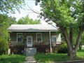
 view gallery view galleryW12.4 km |  Francois Morel Aubuchon House - Ste. Genevieve, Missouri Francois Morel Aubuchon House - Ste. Genevieve, Missouri
in Pre-Victorian Historic Homes Timber-frame house in the Ste. Genevieve Historic District in Ste. Genevieve, Missouri. posted by: BruceS location: Missouri date approved: 06/05/2008 last visited: never |
|