 view gallery view gallery E5 km E5 km
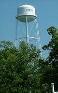
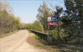
|   Water Tower in Dixon, Missouri Water Tower in Dixon, Missouri
in Water Towers This water tower is a prominent feature in the city park! posted by:  Queens Blessing Queens Blessing location: Missouri date approved: 05/31/2010 last visited: 09/02/2013 |
 view gallery view gallery W10.3 km W10.3 km
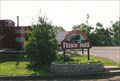
|  Norma Lea Mihalevich (teacher) - Crocker, MO Norma Lea Mihalevich (teacher) - Crocker, MO
in Citizen Memorials The Frisco Park is also dedicated to this woman who gave her life in service to this town. posted by: YoSam. location: Missouri date approved: 12/02/2019 last visited: never |
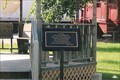
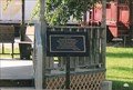
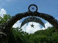
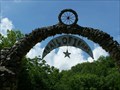
 view gallery view galleryW10.3 km |  Norma Lea's Frisco Park - Crocker, MO Norma Lea's Frisco Park - Crocker, MO
in Municipal Parks and Plazas This park is dedicated to both the railroad history of the town and a long time mayor. Web search shows a veterans memorial in the park, it was not there when I visited. posted by: YoSam. location: Missouri date approved: 02/14/2016 last visited: never |
 view gallery view galleryW10.3 km |  Norma Lea Mihalevich - Crocker, MO Norma Lea Mihalevich - Crocker, MO
in Missouri Historical Markers This park, The Frisco Park, is also dedicated to this woman who gave her life in service to this town. posted by: YoSam. location: Missouri date approved: 02/14/2016 last visited: never |
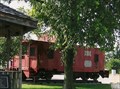 view gallery view galleryW10.3 km |  Frisco # 1418 re-numbered # 11648 - Frisco Park, Crocker, MO Frisco # 1418 re-numbered # 11648 - Frisco Park, Crocker, MO
in Train Cabooses "Crocker MO SLSF 1418 as BN 11648, steel, wide vision, built from boxcar 9/75, 10th & Main" ~ BN list posted by: YoSam. location: Missouri date approved: 05/05/2014 last visited: never |
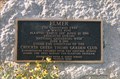 view gallery view galleryW10.3 km | Elmer The Christmas Tree - Crocker, MO in Missouri Historical Markers And yes, the school children decorate it each year. posted by: YoSam. location: Missouri date approved: 02/14/2016 last visited: never |
 view gallery view gallery NW16.3 km NW16.3 km
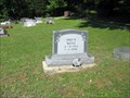
|  103 - Fred R. Moss - Iberia, Missouri 103 - Fred R. Moss - Iberia, Missouri
in Headstones of Centenarians I noticed this headstone and military marker at the Union Cemetery off Hwy 42 in Miller County, Missouri, about 5 miles from Iberia, Missouri. posted by: Queens Blessing location: Missouri date approved: 06/09/2011 last visited: 09/15/2012 |
 view gallery view galleryNW16.3 km |  Union Cemetery, Iberia Missouri Union Cemetery, Iberia Missouri
in Worldwide Cemeteries Union Cemetery is located next to Brays Advent Christian Church but is not associated with that church. posted by: Queens Blessing location: Missouri date approved: 06/01/2011 last visited: 09/15/2012 |
 view gallery view gallery SE16.4 km SE16.4 km
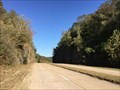
|  Hooker Cut - Devil's Elbow, MO Hooker Cut - Devil's Elbow, MO
in Route 66 - The Mother Road Road cut through solid rock on Route 66 posted by:  Wallyum Wallyum location: Missouri date approved: 05/15/2021 last visited: never |
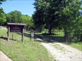
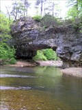 view gallery view galleryE16.7 km |  Clifty Creek Natural Area Maries County, Missouri Clifty Creek Natural Area Maries County, Missouri
in Natural Arches One of the dramatic features of Clifty Creek Natural Area is a natural bridge with a span of about 40 feet created by stream erosion of Gasconade dolomite rock formations. A trail loop of 2.5 miles completed in 2008 affords excellent access. posted by: Carpe Diem59 location: Missouri date approved: 04/30/2010 last visited: 02/21/2011 |
 view gallery view gallerySE16.7 km |  KFLW-FM 98.7 -- St Robert MO USA KFLW-FM 98.7 -- St Robert MO USA
in Radio and Television Transmitter Towers The transmitter tower and an auxiliary tower for KFLW-FM along the I-44 in St. Robert MO posted by: Benchmark Blasterz location: Missouri date approved: 01/25/2022 last visited: 01/26/2022 |
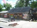
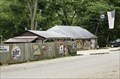
 view gallery view gallerySE16.9 km |  Devil's Elbow Inn - Devil's Elbow, Missouri Devil's Elbow Inn - Devil's Elbow, Missouri
in Classic BBQ and Sandwich Joints Devil's Elbow, MO located along the Big Piney River in the heart of the ozarks.
posted by: Team Farkle 7 location: Missouri date approved: 08/28/2007 last visited: 12/03/2019 |
 view gallery view gallerySE16.9 km |  Bar with Bras on the Ceiling - Devil's Elbow, Missouri Bar with Bras on the Ceiling - Devil's Elbow, Missouri
in Roadside Attractions Bar almost washed waay in 2017 flood, restored to 1950's version, and better than ever... posted by: YoSam. location: Missouri date approved: 12/03/2019 last visited: never |
 view gallery view gallerySE16.9 km | Devil's Elbow Inn - Devil's Elbow, Missouri in Route 66 - The Mother Road Devil's Elbow, MO located along the Big Piney River in the heart of the ozarks.
posted by: Team Farkle 7 location: Missouri date approved: 07/10/2007 last visited: 10/19/2017 |
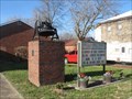 view gallery view galleryNW17.1 km |  Bell of Congregational Church, Iberia, MO Bell of Congregational Church, Iberia, MO
in Bells A cast steel bell, presumably from a former building, stands on a brick and concrete pedestal outside the present building of the Congregational Church. posted by: STLbells location: Missouri date approved: 01/03/2022 last visited: never |
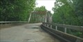 view gallery view gallerySE17.2 km |  Big Piney River Truss Bridge, Devils Elbow, MO Big Piney River Truss Bridge, Devils Elbow, MO
in Truss Bridges This truss bridge provides safe passage over Big Piney River, using the historic old Route 66. posted by: Queens Blessing location: Missouri date approved: 05/31/2010 last visited: 08/21/2022 |
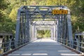 view gallery view gallerySE17.2 km | Big Piney Truss Bridge - Devil's Elbow, MO in Route 66 - The Mother Road Bridge is over the area they call the Elbows... posted by: YoSam. location: Missouri date approved: 12/03/2019 last visited: 08/21/2022 |
 view gallery view gallerySE17.2 km | Devil's Elbow - Devil's Elbow, MO in Missouri Historical Markers A bad bend in the river becomes a landmark. posted by: YoSam. location: Missouri date approved: 06/17/2008 last visited: 02/25/2012 |
 view gallery view gallerySE17.2 km | Devil's Elbow, Devil's Elbow, MO in Route 66 - The Mother Road A bad bend in the river, under a railroad track, in Pulaski County, MO. posted by: YoSam. location: Missouri date approved: 06/15/2008 last visited: 06/02/2022 |
 view gallery view gallerySE17.2 km |  Devil's Elbow - Pulaski County, MO Devil's Elbow - Pulaski County, MO
in Scenic Roadside Look-Outs A bit grown up now that it is no longer on a major road that tourist travel. posted by: YoSam. location: Missouri date approved: 04/30/2014 last visited: never |
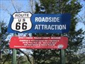
 view gallery view gallerySE17.4 km | Larry Baggett's Trail of Tears Memorial - Jerome, MO in Roadside Attractions Trail of Tears Monument on one man's land. posted by: Team Farkle 7 location: Missouri date approved: 06/14/2009 last visited: 07/23/2011 |
 view gallery view gallerySE17.4 km | Trail of Tears Monument - Jerome, MO in Route 66 - The Mother Road Trail of Tears Monument on one man's land posted by: Team Farkle 7 location: Missouri date approved: 06/30/2007 last visited: 07/23/2011 |
 view gallery view gallerySE17.4 km |  Trail of Tears Monument - Jerome, MO Trail of Tears Monument - Jerome, MO
in Trail of Tears Trail of Tears Monument on one man's land posted by: Team Farkle 7 location: Missouri date approved: 07/01/2007 last visited: 07/23/2011 |
 view gallery view gallerySE17.4 km |  Devil's Elbow, MO Devil's Elbow, MO
in Geological Devilish Locations Devil's Elbow, Missouri located along the Big Piney River in the heart of the ozarks. posted by: Jhwk location: Missouri date approved: 12/06/2005 last visited: 02/04/2022 |
 view gallery view gallerySE17.4 km |  ‘Devil’s Elbow is Gone’ - Devil's Elbow, MO ‘Devil’s Elbow is Gone’ - Devil's Elbow, MO
in News Article Locations County official: ‘Devil’s Elbow is gone’... posted by: YoSam. location: Missouri date approved: 12/03/2019 last visited: never |
|