 view gallery view gallery NW0 km NW0 km
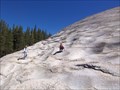
|   Mount Conness Mount Conness
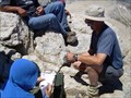
in Summit Registers At 12,590 feet, Mount Conness is the tallest peak in the Sierra Nevada North of Tioga Pass. posted by:  Touchstone Touchstone location: California date approved: 08/22/2007 last visited: never |
 view gallery view gallery SE6.9 km SE6.9 km
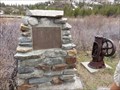
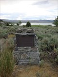
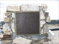
|  Bennettville - Yosemite NP, California Bennettville - Yosemite NP, California
in E Clampus Vitus Historical Markers Reason why the Tioga Road was built posted by: jimnade location: California date approved: 06/13/2015 last visited: never |
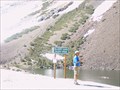 view gallery view gallerySE8.2 km |  Yosemite - Ellery Lake Yosemite - Ellery Lake
in Elevation Signs Ellery Lake at the Tioga Pass near the east entrance of Yosemite. posted by:  eveningrose eveningrose location: California date approved: 08/15/2010 last visited: 05/14/2013 |
 view gallery view gallery E8.5 km E8.5 km
| The Tioga Pass Road - Lee Vining CA- Elevation 9945' in Elevation Signs The Tioga Pass Road Constructed 1883 & 1910. Tioga Pass at 9945 feet is the highest automobile pass in California. The road to the pass was constructed in two parts. posted by: Don.Morfe location: California date approved: 08/10/2020 last visited: 10/30/2021 |
 view gallery view gallery S9.7 km S9.7 km
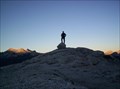
|  Lembert Dome Lembert Dome
in Mountain Summits Located within Yosemite National Park, this high point in Tuolumne Meadows offers a 360 degree view for the price of a moderate hike. posted by: Touchstone location: California date approved: 08/30/2005 last visited: 02/20/2015 |
 view gallery view gallery SW11.4 km SW11.4 km
|  Pothole Dome Pothole Dome
in Places of Geologic Significance Pothole Dome in Tuolumne Meadows provides an excellent opportunity to view typical glacial erosional and geomorphologic features and some not so typical ones as well. posted by: TerryDad2 location: California date approved: 01/03/2010 last visited: 02/20/2015 |
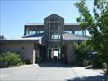
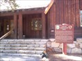 view gallery view gallerySW11.6 km |  Yosemite NP: Tuolumne Meadows Visitors Center Yosemite NP: Tuolumne Meadows Visitors Center
in NPS Passport Cancellation Stations Located in the historic Visitors Center in Tuolumne Meadows. Coordinates were taken at the base of the stairway leading to the front door. posted by: Touchstone location: California date approved: 08/30/2005 last visited: 06/26/2014 |
 view gallery view gallerySW11.6 km |  Yosemite NP: Tuolumne Meadows Visitors Center Yosemite NP: Tuolumne Meadows Visitors Center
in Civilian Conservation Corps The CCC was very active in Yosemite National Park between 1933 to 1942. The Tuolumne Meadows Visitors Center is just one of many projects that the CCC performed to make the Park what it is today. posted by: Touchstone location: California date approved: 09/05/2005 last visited: 06/29/2012 |
 view gallery view galleryE16.4 km | Sheriff James P. Dolan in E Clampus Vitus Historical Markers Located at the Mono Lake Tufa State Natural Reserve. Found this while visiting the tufa. The marker is at the entrance to the parking lot of the picnic area. posted by: fresgo location: California date approved: 07/13/2010 last visited: 10/30/2018 |
 view gallery view galleryE17.2 km |  LV for Lee Vining LV for Lee Vining
in Letters on Hills The 'LV' representing the town of Lee Vining is located on a hillside on the west side of central Lee Vining, California. posted by: brwhiz location: California date approved: 02/25/2013 last visited: 10/30/2018 |
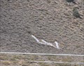
 view gallery view galleryE17.2 km |  American Legion - Mono City, CA American Legion - Mono City, CA
in Veteran Cemeteries American Legion cemetery is located in Mono Lake, CA. posted by: tatie location: California date approved: 10/22/2013 last visited: 10/30/2018 |
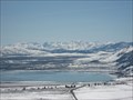 view gallery view gallery NE17.4 km NE17.4 km
|  Mono Diggins - Mono Lake, CA Mono Diggins - Mono Lake, CA
in Scenic Overlooks An AMAZING view of Mono Lake. posted by: bluesnote location: California date approved: 10/05/2010 last visited: 10/03/2015 |
 view gallery view galleryNE17.4 km |  Mono Diggins - Mono Lake, CA Mono Diggins - Mono Lake, CA
in Scenic Roadside Look-Outs Awesome view off of 395. posted by: bluesnote location: California date approved: 04/21/2016 last visited: 06/22/2018 |
 view gallery view galleryNE17.4 km | Mono Diggins - Mono Lake, CA in E Clampus Vitus Historical Markers Awesome view off of 395. posted by: bluesnote location: California date approved: 05/20/2010 last visited: 05/31/2012 |
 view gallery view galleryE17.5 km |  Gardening for birds and butterflies - Mono Basin, CA Gardening for birds and butterflies - Mono Basin, CA
in Butterfly Gardens Gardening for birds and butterflies is located in Mono Lake, CA. posted by: tatie location: California date approved: 10/21/2013 last visited: 03/02/2014 |
 view gallery view galleryE17.7 km |  Mono Basin Visitor Center - Lee Vining, CA Mono Basin Visitor Center - Lee Vining, CA
in Ranger Stations This big center have info on Mono Lake and the surrounding area. It's located on highway 395 just outside of Lee Vining. posted by: Free2bme29 location: California date approved: 07/24/2009 last visited: 10/30/2018 |
 view gallery view galleryE17.7 km | Upside - Down House in E Clampus Vitus Historical Markers A house built upside down, from outside structure to inside furnishings. Inspired by children's books. Marker is in Lee Vining, California, 93541 in Mono County. posted by: FindersKeepersLTD location: California date approved: 09/05/2008 last visited: 02/14/2014 |
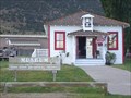 view gallery view galleryE17.7 km |  The Old School House Museum - Lee Vining, CA The Old School House Museum - Lee Vining, CA
in History Museums Located in Mono Lake's Old School House, this museum displays both the commonplace and delightfully odd artifacts, photographs, books, maps and equipment chronicling the cultural history of the Mono Basin. posted by: FindersKeepersLTD location: California date approved: 09/02/2008 last visited: 06/30/2012 |
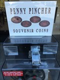
 view gallery view galleryE17.7 km |  Lee Vining (Gone) Lee Vining (Gone)
in Penny Smashers This penny smasher is outside the local breakfast restaraunt of Niceley's in the small little town of Lee Vining on the East side of the Sierra Nevada Range. posted by: Touchstone location: California date approved: 09/05/2005 last visited: 08/13/2012 |
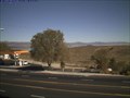 view gallery view galleryE17.7 km |  Lee Vining Webcam Lee Vining Webcam
in Web Cameras Easy Webcam Cache. Beautiful view. Photo updates every 5 minutes. posted by: XB70man location: California date approved: 10/09/2008 last visited: 12/27/2008 |
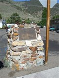 view gallery view galleryE17.7 km | Lee Vining - CA in E Clampus Vitus Historical Markers This marker describes the naming of the community of Lee Vining. posted by: Free2bme29 location: California date approved: 07/15/2009 last visited: 07/04/2012 |
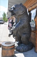 view gallery view galleryE17.7 km |  Bronze Bear Outpost Grizzly Bronze Bear Outpost Grizzly
in Bear Statues This life-size bronze statue of a grizzly bear standing vertically is located in front of the Bronze Bear Outpost at 51321 US Highway 395 in Lee Vining, California. posted by: brwhiz location: California date approved: 02/25/2013 last visited: 02/14/2014 |
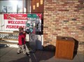
 view gallery view galleryE18.3 km | Whoa Nellie Deli, Lee Vining in Penny Smashers Four design penny smasher at the Whoa Nellie Deli (Mobil) in Lee Vining posted by: kablooey location: California date approved: 08/01/2015 last visited: never |
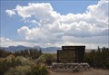 view gallery view gallerySE21.1 km | Mono Craters in Places of Geologic Significance This Inyo National Forest sign explaining the significance of volcanic activity in the vicinity of Mono Lake is located in a turnout on the southeast side of California Highway 158 about 1.1 miles southwest of the junction with US Highway 395. posted by: brwhiz location: California date approved: 02/26/2013 last visited: 10/03/2015 |
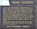 view gallery view gallerySE21.1 km |  Mono Craters Mono Craters
in Signs of History This Inyo National Forest sign explaining the history of volcanic activity in the vicinity of Mono Lake is located in a turnout on the southeast side of California Highway 158 about 1.1 miles southwest of the junction with US Highway 395. posted by: brwhiz location: California date approved: 02/25/2013 last visited: never |
|