 view gallery view gallery W2.6 km W2.6 km
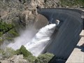
|   O' Shaughnessy Dam O' Shaughnessy Dam
in Water Dams This is the famous Hetch Hetchy Lake and it's dam. The dam is around 435 feet tall and hides a valley that John Muir once thought was as beautiful as Yosemite Valley. posted by:  emjc emjc location: California date approved: 05/20/2007 last visited: 06/28/2013 |
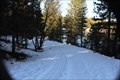 view gallery view galleryW13.8 km |  Cherry Lake Boat Launch Cherry Lake Boat Launch
in Boat Ramps Boat launch into Cherry Lake at Cherry Valley Dam, near Groveland, Ca. posted by:  kdczy kdczy location: California date approved: 01/27/2011 last visited: 01/29/2011 |
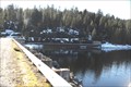 view gallery view galleryW13.8 km | Cherry Valley Dam in Water Dams Cherry Valley Dam near Groveland, Ca. posted by: kdczy location: California date approved: 01/19/2011 last visited: 01/17/2011 |
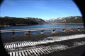 view gallery view galleryW14 km |  Cherry Lake Cherry Lake
in Fishing Holes Cherry Lake, near Groveland, Ca. posted by: kdczy location: California date approved: 01/19/2011 last visited: 01/17/2011 |
  NE17.7 km NE17.7 km
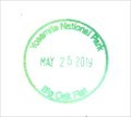
|  Yosemite an enduring Treasure CA Yosemite an enduring Treasure CA
in There's a Book About It The cover photo is Upper Yosemite Falls but you can log within the range.
A 10" x 12" color paperback, 50 pgs. 2001 by the Yosemite Association. posted by: sbcamper location: California date approved: 07/09/2009 last visited: 03/30/2014 |
 view gallery view gallery SW19.6 km SW19.6 km
|  Yosemite NP - Big Oak Flat Entrance Station Yosemite NP - Big Oak Flat Entrance Station
in NPS Passport Cancellation Stations This stamp is located at the Big Oak Flat Welcome Center Complex. Ask the ranger at the park gate for the stamp. posted by: DopeyDuck location: California date approved: 06/23/2019 last visited: never |
 view gallery view gallery S24.6 km S24.6 km
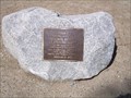
|  Stephen Tyng Mather - Yosemite National Park - California Stephen Tyng Mather - Yosemite National Park - California
in Citizen Memorials This plaque is on a trail near the Happy Islands Nature Center in Yosemite National Park. posted by: GT.US location: California date approved: 01/20/2010 last visited: never |
 view gallery view galleryS25.7 km |  Waterfalls: The Cascades Waterfalls: The Cascades
in Waterfalls The Cascades in Yosemite National Park posted by: 50sumtin location: California date approved: 01/08/2006 last visited: 03/12/2022 |
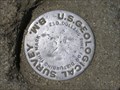
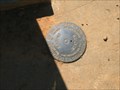 view gallery view gallerySW26.6 km |  Rainbow Pools Gaging Station Rainbow Pools Gaging Station
in U.S. Benchmarks A bronze disk set in concrete. posted by: dmchapman location: California date approved: 01/29/2006 last visited: never |
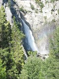
 view gallery view gallery SE26.7 km SE26.7 km
|  Lower Yosemite Falls - Yosemite National Park - California Lower Yosemite Falls - Yosemite National Park - California
in Ansel Adams Photo Hunt These are the Lower Yosemite falls at Yosemite National Park. posted by: GT.US location: California date approved: 02/01/2010 last visited: 03/12/2022 |
 view gallery view galleryS26.7 km |  Half Dome View Scenic Overlook, Yosemite National Park Half Dome View Scenic Overlook, Yosemite National Park
in Philatelic Photographs When approaching Yosemite Valley from the north, one's first glimpse of Half Dome is from this scenic overlook on Big Oak Flat Road. posted by: hykesj location: California date approved: 06/14/2013 last visited: 11/10/2015 |
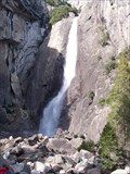
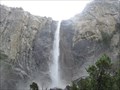 view gallery view gallerySE26.7 km |  Yosemite Falls - Yosemite, CA Yosemite Falls - Yosemite, CA
in American Guide Series Here is one of the most iconic waterfalls in the world. posted by: bluesnote location: California date approved: 03/20/2016 last visited: 03/12/2022 |
 view gallery view gallerySE26.7 km |  Yosemite Falls - Yosemite, CA Yosemite Falls - Yosemite, CA
in Official Local Tourism Attractions Here is one of the most iconic waterfalls in the world. posted by: bluesnote location: California date approved: 11/08/2017 last visited: 03/12/2022 |
 view gallery view gallerySE26.7 km |  Yosemite Falls - Yosemite National Park, CA Yosemite Falls - Yosemite National Park, CA
in Wikipedia Entries Here is one of the most iconic waterfalls in the world. posted by: bluesnote location: California date approved: 02/14/2014 last visited: 03/12/2022 |
 view gallery view gallerySE26.7 km | El Capitan - Yosemite, CA in Wikipedia Entries El Capitan in Yosemite National Park. posted by: bluesnote location: California date approved: 01/14/2017 last visited: 08/01/2023 |
 view gallery view gallerySE26.7 km | El Capitan - Yosemite, CA in Official Local Tourism Attractions El Capitan in Yosemite National Park. posted by: bluesnote location: California date approved: 11/08/2017 last visited: 08/01/2023 |
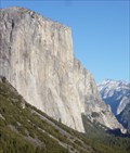 view gallery view gallerySE26.7 km |  El Capitan - Yosemite, CA El Capitan - Yosemite, CA
in Established Rock Climbing Areas El Capitan in Yosemite National Park. posted by: bluesnote location: California date approved: 07/13/2017 last visited: 08/01/2023 |
 view gallery view gallerySE26.7 km | Yosemite Falls - Yosemite NP, California USA in Waterfalls Yosemite Falls, Yosemite NP, California posted by: fishingwishing location: California date approved: 11/07/2007 last visited: 05/03/2022 |
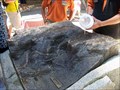 view gallery view gallerySE26.7 km |  Yosemite Falls Water Flow - Yosemite, CA Yosemite Falls Water Flow - Yosemite, CA
in Outdoor Interactive Science Displays A sculpture of Yosemite Falls is used to demonstrate seasonal water flow. posted by: Bernd das Brot Team location: California date approved: 11/05/2011 last visited: 03/30/2014 |
 view gallery view gallerySE26.7 km |  Camp 4, Yosemite Valley Camp 4, Yosemite Valley
in U.S. National Register of Historic Places One of the most recent entries to the National Historic Registry, Camp 4 (as it is commonly referred to) is an internationally recognized campground in Yosemite Valley, that has for generations, been a base camp for visiting climbers to this internationally known climbing area. posted by: Touchstone location: California date approved: 03/21/2007 last visited: 02/08/2015 |
 view gallery view gallerySE26.7 km | Columbia Rock in U.S. Benchmarks The mark is located at Columbia Rock on the Upper Yosemite Fall Trail in Yosemite National Park. posted by: ltleelim location: California date approved: 01/28/2006 last visited: 01/14/2015 |
 view gallery view gallerySE26.7 km |  El Capitan - Yosemite, CA El Capitan - Yosemite, CA
in Satellite Imagery Oddities El Capitan in Yosemite National Park. posted by: bluesnote location: California date approved: 01/11/2017 last visited: 08/01/2023 |
 view gallery view gallerySE26.7 km |  El Capitan - Yosemite, CA El Capitan - Yosemite, CA
in Numismatic Photographs El Capitan in Yosemite National Park is also on the back of the U.S. Quarter. posted by: bluesnote location: California date approved: 01/05/2014 last visited: 11/10/2015 |
 view gallery view galleryS27 km | Wawona Tunnel - Yosemite, CA in American Guide Series Wawona Tunnel is the tunnel of darkness, and in to the most amazing view of the natural world on the other side. posted by: bluesnote location: California date approved: 03/20/2016 last visited: 03/20/2016 |
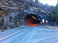 view gallery view galleryS27 km | Wawona Tunnel - Yosemite, CA in Satellite Imagery Oddities Wawona Tunnel is the tunnel of darkness, and in to the most amazing view of the natural world on the other side. posted by: bluesnote location: California date approved: 01/11/2017 last visited: 01/11/2017 |
|