 view gallery view gallery NE2.7 km NE2.7 km
|   Oak Hall, VA Oak Hall, VA
in U.S. Post Offices Oak Hall, VA U.S. Post Office posted by:  wilsonjw wilsonjw location: Virginia date approved: 09/06/2017 last visited: never |
 view gallery view galleryNE5 km |  Pizza Hut - Lankford Hwy - Oak Hall, VA Pizza Hut - Lankford Hwy - Oak Hall, VA
in Pizza Hut Restaurants This is the Pizza Hut location in Oak Hall, VA. posted by:  retail96 retail96 location: Virginia date approved: 10/14/2018 last visited: never |
 view gallery view gallery SE5.1 km SE5.1 km
| Assawoman, VA - 23302 in U.S. Post Offices If you think you live in the armpit of the country...how about an anatomic change? Assawoman, Virginia is about 10 miles south of Chincoteague. The post office is on Route 679 (Atlantic Rd). posted by: 94RedRover location: Virginia date approved: 10/01/2010 last visited: never |
 view gallery view gallerySE6.1 km |  Assawoman United Methodist Church - Assawoman, VA Assawoman United Methodist Church - Assawoman, VA
in Country Churches Assawoman, Virginia, a town with a population of 89, is just 10 miles south of Chincoteague on the eastern shore of the Delmarva Peninsula. posted by: 94RedRover location: Virginia date approved: 10/11/2010 last visited: never |
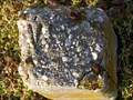 view gallery view galleryNE6.9 km |  Virginia DOH Right-of-Way Marker, Wallops Area, VA Virginia DOH Right-of-Way Marker, Wallops Area, VA
in U.S. Historic Survey Stones and Monuments A Virginia Department of Highways (Predecessor to Virginia Department of Transportation) Right-of-Way Marker. posted by: bluesnote location: Virginia date approved: 12/18/2013 last visited: 12/18/2013 |
 view gallery view gallery E6.9 km E6.9 km
|  Navy Bomber Crash Near Atlantic, VA in 1957 Killed 11 Crewmen Navy Bomber Crash Near Atlantic, VA in 1957 Killed 11 Crewmen
in Plane Crash Sites A Navy P2V-6M Neptune Crash in April 1957 Killed Eleven Crewmen. posted by: fullxr location: Virginia date approved: 12/12/2012 last visited: never |
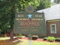 view gallery view gallery N9.5 km N9.5 km
|  Lankford Highway (US Rt. 13 Southbound), New Church, VA Lankford Highway (US Rt. 13 Southbound), New Church, VA
in Blue Star Memorial Highway Markers Blue Star Memorial Highway Marker on US Route 13 Southbound, New Church, VA. posted by: Team Smokey location: Virginia date approved: 08/02/2009 last visited: 08/09/2022 |
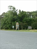
 view gallery view galleryN9.5 km |  Virginia Welcome Center Virginia Welcome Center
in Highway Rest Areas Virginia Welcome Center located on US Rt. 13 Southbound posted by: Team Smokey location: Virginia date approved: 07/31/2009 last visited: 08/09/2022 |
 view gallery view galleryE10.5 km | Navy F4U4 Corsair Crashes Near Chincoteague Island, VA in 1954 in Plane Crash Sites A High-Altitude Navy Test Firing Mission Ends in Tragedy on a Beautiful Summer Morning in 1954. posted by: fullxr location: Virginia date approved: 12/13/2012 last visited: 11/24/2018 |
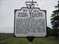 view gallery view galleryE10.5 km |  NASA Wallops Flight Facility NASA Wallops Flight Facility
in Virginia Historical Markers NASA Wallops Flight Facility - Virginia Historical Marker located on Rt. 175. posted by: Team Smokey location: Virginia date approved: 07/26/2009 last visited: 07/21/2020 |
 view gallery view galleryE10.5 km |  Science on a Sphere - Wallops Island Flight Facility, Wallops Island, VA Science on a Sphere - Wallops Island Flight Facility, Wallops Island, VA
in Solar System Models NASA's Wallops Island Flight Facility Visitor Center has an amazing exhibit called Science on a Sphere, which uses real scientific data to provide an interactive look at the earth and other planets and moons in our solar system. posted by: 94RedRover location: Virginia date approved: 02/16/2015 last visited: never |
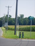
 view gallery view galleryN10.6 km |  Maryland/Virginia Border at U.S. 13 Maryland/Virginia Border at U.S. 13
in Border Crossings A main highway crossing between MD & VA on the Delmarva Peninsula. posted by: Ernmark location: Virginia date approved: 09/25/2012 last visited: 09/23/2019 |
 view gallery view galleryN10.6 km | Virginia - Maryland State Line - Marva Road in Border Crossings VA - MD border located just off US Rt. 13 on Marva Road. posted by: Team Smokey location: Virginia date approved: 07/28/2009 last visited: 10/05/2019 |
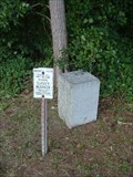 view gallery view galleryN10.6 km |  BOUNDARY MONUMENT (HU1835/HU0523) - MD/VA BOUNDARY MONUMENT (HU1835/HU0523) - MD/VA
in U.S. Benchmarks Stone border monument dating back to 1883. posted by: Ernmark location: Virginia date approved: 09/10/2012 last visited: 10/05/2019 |
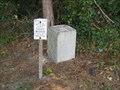
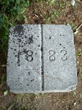 view gallery view galleryN10.6 km |  Maryland/Virginia Boundary N of Marva RD Near US 13 Maryland/Virginia Boundary N of Marva RD Near US 13
in Public Land Survey Marks Granite Post dating back to an 1883 survey of the MD/VA state line. posted by: Ernmark location: Virginia date approved: 04/04/2013 last visited: 10/05/2019 |
 view gallery view galleryN10.9 km | Maryland Welcome Center, US Rt. 13 Northbound in Highway Rest Areas Maryland Welcome Center located on US Rt. 13 Northbound posted by: Team Smokey location: Maryland date approved: 07/28/2009 last visited: 12/02/2019 |
 view gallery view galleryN10.9 km |  TIC - US Rte. 13 Eastern Shore Maryland TIC - US Rte. 13 Eastern Shore Maryland
in Tourist Information Centers - Visitor Centers Welcome Center on the Eastern Shore of Maryland. posted by: sfwife location: Maryland date approved: 09/18/2007 last visited: 07/21/2020 |
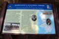 view gallery view galleryN10.9 km |  Maryland's Eastern Shore-Hundreds of Enslaved and Free Black Men Enlisted-Pocomoke City, MD Maryland's Eastern Shore-Hundreds of Enslaved and Free Black Men Enlisted-Pocomoke City, MD
in Civil War Discovery Trail Sites Located in the Maryland Welcome Center at the Virginia/Maryland State Line on US 13. posted by: Markerman62 location: Maryland date approved: 08/02/2020 last visited: 07/30/2020 |
 view gallery view galleryN10.9 km |  Boundary Line Maryland - Virginia Boundary Line Maryland - Virginia
in Maryland Historical Markers Boundary Line Maryland - Virginia Historical Marker located at the Maryland Welcome Center on US Rt. 13 posted by: Team Smokey location: Maryland date approved: 07/27/2009 last visited: 06/30/2021 |
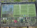 view gallery view galleryN11.9 km |  Protecting the Pocomoke River, Pocomoke, MD Protecting the Pocomoke River, Pocomoke, MD
in Flora and Fauna Information Signs Near the Pocomoke River, a sign by the Maryland Department of Natural Ressources posted by: LeGrandChrist location: Maryland date approved: 08/23/2015 last visited: never |
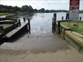 view gallery view galleryN11.9 km |  Worcester County public landing, Pocomoke River, MD Worcester County public landing, Pocomoke River, MD
in Boat Ramps Public landing on the Pocomoke River posted by: LeGrandChrist location: Maryland date approved: 08/30/2015 last visited: never |
 view gallery view galleryE14.3 km | Grumman F9F Panther Navy Jet Crashes in Atlantic Ocean in 1956 in Plane Crash Sites Pilot was on a Tracking Operation with a Navy Baltimore-Class Heavy Cruiser, the USS Macon (CA-132). posted by: fullxr location: Virginia date approved: 01/06/2013 last visited: 11/25/2018 |
 view gallery view galleryE14.5 km |  Science on a Sphere - Wallops Island Flight Facility, Wallops Island, VA Science on a Sphere - Wallops Island Flight Facility, Wallops Island, VA
in Earth Globes NASA's Wallops Island Flight Facility Visitor Center has an amazing exhibit called Science on a Sphere, which uses real scientific data to provide an interactive look at the earth and other planets and moons in our solar system. posted by: 94RedRover location: Virginia date approved: 10/10/2010 last visited: 10/07/2012 |
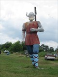 view gallery view galleryE16.1 km |  Chincoteague Island Viking Chincoteague Island Viking
in Highway Giants - Muffler Men Viking Muffler Man located in/on Chincoteague Island, VA posted by: Team Smokey location: Virginia date approved: 07/30/2009 last visited: 08/19/2021 |
 view gallery view galleryNE16.7 km | Maryland/Virginia Crossing at MD12/VA679 in Border Crossings Rural crossing between Maryland and Virginia, along a route that serves as a scenic 'short cut' between Berlin/Ocean City and Chincoteague. posted by: Ernmark location: Virginia date approved: 09/25/2012 last visited: 03/22/1994 |
|