 view gallery view gallery NE12.1 km NE12.1 km
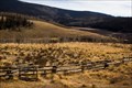
|   Lake San Cristobal Scenic Overlook - Lake City, CO Lake San Cristobal Scenic Overlook - Lake City, CO
in Scenic Roadside Look-Outs This overlook provides a panoramic view of Lake San Cristobal, Colorado's second largest natural lake. posted by:  IJAdventures IJAdventures location: Colorado date approved: 12/22/2012 last visited: 09/25/2015 |
 view gallery view galleryNE12.9 km |  Alferd Packer - Lake City, CO Alferd Packer - Lake City, CO
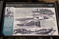
in Colorado Historical Markers "You man eating son of a .... There was seven Democrats in Hinsdale County and you ate five of them." (attributed to Lake City saloon keeper Larry Dolan) posted by: IJAdventures location: Colorado date approved: 12/22/2012 last visited: 09/25/2015 |
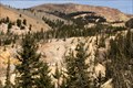
 view gallery view galleryNE12.9 km |  Alferd Packer: Man-Eater - Lake City, CO Alferd Packer: Man-Eater - Lake City, CO
in Weird Story Locations The legend of how one man survived a winter by eating the flesh of his companions. posted by: IJAdventures location: Colorado date approved: 04/06/2013 last visited: 09/25/2015 |
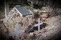
 view gallery view galleryNE12.9 km |  Alferd Packer Cannibal Massacre Site - Lake City, CO Alferd Packer Cannibal Massacre Site - Lake City, CO
in Roadside Attractions "The Alferd Packer Massacre Site, a remote wilderness in 1874, is now only five minutes south of the Lake City miniature golf course." - RoadsideAmerica.com posted by: IJAdventures location: Colorado date approved: 12/22/2012 last visited: 09/25/2015 |
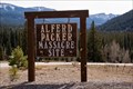
 view gallery view galleryNE12.9 km |  Alferd Packer Massacre - Lake City, CO Alferd Packer Massacre - Lake City, CO
in Infamous Crime Scenes Colorado's legendary massacre site lies just outside the present day town of Lake City where mountain guide Alferd Packer was accused and tried for the murder and cannibalism of his fellow travelers. posted by: IJAdventures location: Colorado date approved: 12/22/2012 last visited: 09/25/2015 |
 view gallery view galleryNE13.5 km |  Slumgullion Earthflow - Lake City, CO Slumgullion Earthflow - Lake City, CO
in U.S. National Natural Landmarks This 700 year old massive earthslide is a rare example of "mass wasting" and designated a National Natural Landmark in 1965. posted by: IJAdventures location: Colorado date approved: 12/11/2012 last visited: 09/07/2015 |
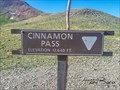 view gallery view gallery W14.2 km W14.2 km
|  Cinnamon Pass, CO (12,640 ft.) Cinnamon Pass, CO (12,640 ft.)
in Elevation Signs Cinnamon Pass is located in the San Juan Mountians. posted by: mr.volkswagen location: Colorado date approved: 08/06/2018 last visited: 08/06/2018 |
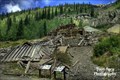 view gallery view gallery NW14.6 km NW14.6 km
|  Empire Chief Mine and Mill - Lake City, CO Empire Chief Mine and Mill - Lake City, CO
in U.S. National Register of Historic Places Empire Chief Mine and Mill is along the Alpine Loop Byway. You will drive right by the site as you are going towards Lake City or towards Engineer Pass. Site is right next to the road. posted by: mr.volkswagen location: Colorado date approved: 09/08/2014 last visited: 09/08/2014 |
 view gallery view galleryNW14.6 km |  Bonanza Empire Chief Mine - Hinsdale County, CO Bonanza Empire Chief Mine - Hinsdale County, CO
in Mines The Bonanza Empire Chief Mine is located on the Alpine Loop Trail. posted by: mr.volkswagen location: Colorado date approved: 09/14/2014 last visited: never |
 view gallery view galleryNE15 km |  Windy Point Overlook Orientation Table - Lake City, CO Windy Point Overlook Orientation Table - Lake City, CO
in Orientation Tables Windy Point Overlook offers spectacular views of the San Juan Mountains including Wetterhorn Peak (14,015 ft) and Uncompahgre Peak (14,309 ft). posted by: IJAdventures location: Colorado date approved: 12/08/2012 last visited: 09/25/2015 |
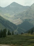
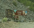 view gallery view galleryNW16.3 km |  Alpine Loop National Back Country Byway - Colorado Alpine Loop National Back Country Byway - Colorado
in National Scenic Byways Following an historic 1800's mining road, the Alpine Loop was one of the Bureau of Land Management's first backcountry byways. posted by:  94RedRover 94RedRover location: Colorado date approved: 06/07/2009 last visited: 08/30/2014 |
 view gallery view galleryW16.4 km | San Juan Skyway - Animas Forks, CO in National Scenic Byways Day two, stop two of the San Juan Skyway Must See Scenic Byway are the ghost towns outside of Silverton, Colorado. posted by: 94RedRover location: Colorado date approved: 01/31/2009 last visited: 10/03/2021 |
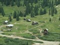
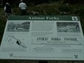 view gallery view galleryW16.4 km |  Animas Forks, Colorado Animas Forks, Colorado
in Signs of History "Three Forks of the Animus" as it was once called, was a prosperous mining town, is now a ghost town visited by 100,000 visitors a year. posted by: 94RedRover location: Colorado date approved: 01/31/2009 last visited: 10/03/2021 |
 view gallery view galleryW16.4 km |  Animas Forks, Colorado Animas Forks, Colorado
in Ghost Towns "Three Forks of the Animus" as it was once called, was a prosperous mining town, is now a ghost town visited by 100,000 visitors a year. posted by: 94RedRover location: Colorado date approved: 02/01/2009 last visited: 10/03/2021 |
 view gallery view galleryW16.4 km |  Animas Forks, Colorado Animas Forks, Colorado
in Wikipedia Entries "Three Forks of the Animus" as it was once called, was a prosperous mining town, is now a ghost town visited by 100,000 visitors a year. posted by: 94RedRover location: Colorado date approved: 01/31/2009 last visited: 10/03/2021 |
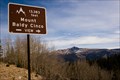 view gallery view galleryNE17.9 km | Mt. Baldy Cinco View - Rio Grande National Forest, CO in Scenic Roadside Look-Outs This overlook provides a stunning view of 13,383 ft Mount Baldy Cinco and the La Garita Mountains. posted by: IJAdventures location: Colorado date approved: 12/06/2012 last visited: never |
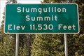 view gallery view galleryNE18 km | 11,530 Feet - Slumgullion Summit - Lake City, CO in Elevation Signs The summit of Slumgullion Pass is the highest point along the Silver Thread Scenic Byway (SH 149) near Lake City. posted by: IJAdventures location: Colorado date approved: 12/06/2012 last visited: 09/25/2015 |
 view gallery view galleryW19.2 km |  International Scout - San Juan County, CO International Scout - San Juan County, CO
in Abandoned Dead Vehicles Located in San Juan County just off of Animas Forks Rd. posted by: mr.volkswagen location: Colorado date approved: 08/04/2015 last visited: never |
 view gallery view gallery E19.8 km E19.8 km
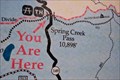
|  "You Are Here" at Spring Creek Pass, CO "You Are Here" at Spring Creek Pass, CO
in 'You Are Here' Maps You are at one of the few places where the Continental Divide Trail and Colorado Trail meet. posted by: IJAdventures location: Colorado date approved: 12/05/2012 last visited: never |
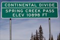 view gallery view galleryE19.8 km | 10,898 Feet - Spring Creek Pass, CO in Elevation Signs Spring Creek Pass is located at an elevation of 10,898 feet on the Continental Divide. posted by: IJAdventures location: Colorado date approved: 12/05/2012 last visited: 09/25/2015 |
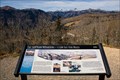
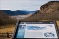 view gallery view galleryE20 km | Headwaters of the Rio Grande Orientation Table - Rio Grande National Forest, CO in Orientation Tables An orientation table located at Browns Lake Overlook near the headwaters of the Rio Grande River. posted by: IJAdventures location: Colorado date approved: 12/01/2012 last visited: 09/07/2015 |
 view gallery view galleryE20 km | "You Are Here" at Browns Lake Overlook - Rio Grande National Forest, CO in 'You Are Here' Maps You are near the headwaters of the Rio Grande River overlooking Brown's Lake and Rio Grande Pyramid (13,821 ft). posted by: IJAdventures location: Colorado date approved: 11/30/2012 last visited: 09/07/2015 |
 view gallery view galleryE20.8 km | Moose Overlook - Rio Grande National Forest, CO in Scenic Roadside Look-Outs If you look carefully, you may spot a moose in the field nearby. posted by: IJAdventures location: Colorado date approved: 12/03/2012 last visited: 09/07/2015 |
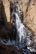 view gallery view galleryE21.1 km |  North Clear Creek Falls - Rio Grande National Forest, CO North Clear Creek Falls - Rio Grande National Forest, CO
in Waterfalls This picturesque waterfall offers a spectacular view any time of the year. posted by: IJAdventures location: Colorado date approved: 12/01/2012 last visited: 09/07/2015 |
 view gallery view galleryW21.7 km | Hurricane Pass, CO (12,730 ft.) in Elevation Signs Hurricane Pass is located in the San Juan Mountains of Colorado. posted by: mr.volkswagen location: Colorado date approved: 08/06/2018 last visited: 08/06/2018 |
|