 view gallery view gallery S8.7 km S8.7 km
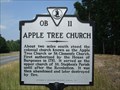
|   Apple Tree Church Apple Tree Church
in Virginia Historical Markers Marker describing a colonial church that was destroyed. posted by:  archway archway location: Virginia date approved: 06/13/2010 last visited: never |
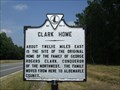 view gallery view galleryS8.7 km | Clark Home in Virginia Historical Markers The family home of George Rogers Clark is described on this marker. posted by: archway location: Virginia date approved: 06/13/2010 last visited: never |
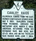 view gallery view galleryS11.6 km | Cavalry Raids in Virginia Historical Markers Cavalry Raids posted by:  johnjm99 johnjm99 location: Virginia date approved: 02/26/2006 last visited: never |
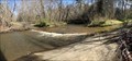
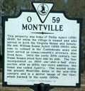 view gallery view galleryS12.9 km | Montville in Virginia Historical Markers Montville Home Site posted by: johnjm99 location: Virginia date approved: 02/26/2006 last visited: never |
 view gallery view gallery SE13.2 km SE13.2 km
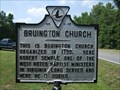
| Bruington Church in Virginia Historical Markers Marker describing a historic church. posted by: archway location: Virginia date approved: 06/13/2010 last visited: never |
 view gallery view gallery NE14.5 km NE14.5 km
|  Breckenridge Road (1st Crossing) - Quantico, Virginia Breckenridge Road (1st Crossing) - Quantico, Virginia
in Bridgeless Water Crossings Located on the western side of Marine Corp Base Quantico. posted by: flyingmoose location: Virginia date approved: 04/11/2023 last visited: never |
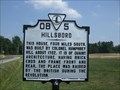 view gallery view gallerySE15.4 km | Hillsboro in Virginia Historical Markers Marker describing a historic home located on the Mattaponi River. posted by: archway location: Virginia date approved: 06/13/2010 last visited: never |
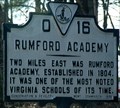 view gallery view galleryS16.3 km | Rumford Academy in Virginia Historical Markers Erected in 1930, Rumford Academy posted by: johnjm99 location: Virginia date approved: 02/26/2006 last visited: never |
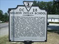 view gallery view galleryS16.9 km | Sharon Indian School in Virginia Historical Markers A one room schoolhouse at this location served Native Americans from 1919 to 1965. posted by: archway location: Virginia date approved: 06/13/2010 last visited: never |
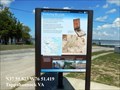
 view gallery view galleryNE16.9 km |  Bountiful Marshes Captain John Smith Chesapeake National Historic Trail - Tappahannock, VA Bountiful Marshes Captain John Smith Chesapeake National Historic Trail - Tappahannock, VA
in Signs of History Bountiful Marshes-Meandering stretches of area rivers, such as this section of the Rappahannock, produce large freshwater marshes. Virginia Indians valued them as rich sources of food, often locating settlements nearby. posted by: Don.Morfe location: Virginia date approved: 01/22/2020 last visited: 09/25/2021 |
 view gallery view gallery E17.5 km E17.5 km
|  Essex Square Antique Mall, Tappahannock, Virginia Essex Square Antique Mall, Tappahannock, Virginia
in Antique Shops Essex Square Antique Mall, Tappahannock, Virginia posted by: Black Dog Trackers location: Virginia date approved: 06/03/2007 last visited: 02/09/2008 |
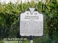 view gallery view galleryE18.2 km | Toppahanock Indian Village in Virginia Historical Markers In this region near the Rappahannock River once stood the Rappahannock Indian village of Toppahanock. When John Smith explored this region in 1607 and 1608, he found fourteen Rappahannock villages along both banks of the river. posted by: Don.Morfe location: Virginia date approved: 03/18/2020 last visited: 10/20/2021 |
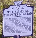
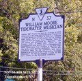 view gallery view galleryE18.7 km | William Moore Tidewater Musician in Virginia Historical Markers William “Bill” Moore was born in Georgia in 1893. Nearby stood his home and barbershop. Paramount recorded Moore in Chicago in 1928 and released eight songs, some of the earliest by an African American folk performer from Virginia. posted by: Don.Morfe location: Virginia date approved: 03/16/2020 last visited: 10/20/2021 |
 view gallery view galleryE18.7 km |  William Moore - Tappahannock VA William Moore - Tappahannock VA
in Civil Rights Memorials William “Bill” Moore was born in Georgia in 1893. Nearby stood his home and barbershop. Paramount recorded Moore in Chicago in 1928 and released eight songs, some of the earliest by an African American folk performer from Virginia. posted by: Don.Morfe location: Virginia date approved: 03/15/2023 last visited: 03/15/2023 |
 view gallery view galleryE18.7 km |  William Moore - Tappahannock VA William Moore - Tappahannock VA
in Citizen Memorials William “Bill” Moore was born in Georgia in 1893. Nearby stood his home and barbershop. Paramount recorded Moore in Chicago in 1928 and released eight songs, some of the earliest by an African American folk performer from Virginia. posted by: Don.Morfe location: Virginia date approved: 03/15/2023 last visited: 03/15/2023 |
 view gallery view galleryE18.8 km | Ritchie's Birthplace in Virginia Historical Markers Virginia Historical Highway Marker N-22, Ritchie's Birthplace. posted by: garmin_geek location: Virginia date approved: 06/01/2011 last visited: 02/08/2014 |
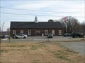 view gallery view galleryE18.8 km |  Tappahannock, VA. 22560 Tappahannock, VA. 22560
in U.S. Post Offices A rural VA post office posted by: pud & pop location: Virginia date approved: 02/06/2008 last visited: 01/19/2013 |
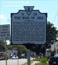 view gallery view galleryE19 km |  The War of 1812 - Tappahannock VA The War of 1812 - Tappahannock VA
in War of 1812 Impressment of Americans into British service and the violation of American ships were among the causes of American War of 1812 with the British, which lasted until 1815. posted by: Don.Morfe location: Virginia date approved: 09/11/2022 last visited: 09/10/2022 |
 view gallery view galleryE19 km | The War of 1812 - Tappahannock VA in Virginia Historical Markers Impressment of Americans into British service and the violation of American ships were among the causes of American War of 1812 with the British, which lasted until 1815. posted by: Don.Morfe location: Virginia date approved: 09/10/2022 last visited: 09/10/2022 |
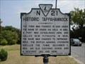 view gallery view galleryE19 km | HISTORIC TAPPAHANNOCK in Virginia Historical Markers Historic Tappahannock founded in 1680. posted by: alaskrt location: Virginia date approved: 08/12/2007 last visited: 09/10/2022 |
 view gallery view galleryE19.2 km | Enduring Records Captain John Smith Chesapeake National Historic Trail - Tappahannock, VA in Signs of History Enduring Records
Smith explored the Rappahannock River in 1607 and 1608. He wrote of his encounters with local tribes in colorful stories of skirmishes and other adventures. Many of these accounts, some published 16 years later, were undoubtedly highly embellished. posted by: Don.Morfe location: Virginia date approved: 01/22/2020 last visited: 09/25/2021 |
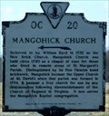 view gallery view gallery SW19.8 km SW19.8 km
| Mangohick Church in Virginia Historical Markers Very unusual name for a place. posted by: johnjm99 location: Virginia date approved: 02/26/2006 last visited: never |
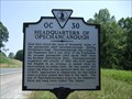 view gallery view galleryS20.3 km | Headquarters of Opechancanough in Virginia Historical Markers Marker describing the Chief of the Pamunkey Tribe. posted by: archway location: Virginia date approved: 06/13/2010 last visited: 02/08/2014 |
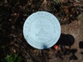 view gallery view galleryS20.9 km |  148 - King William Co., VA 148 - King William Co., VA
in U.S. Benchmarks Pipe cap located at the intersection of Routes 30 & 629. The elevation at this point is 148 ft. posted by: archway location: Virginia date approved: 06/12/2010 last visited: never |
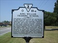 view gallery view galleryS20.9 km | King William Training School in Virginia Historical Markers Marker describing a historic school. posted by: archway location: Virginia date approved: 06/13/2010 last visited: never |
|