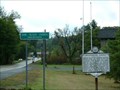
 view gallery view gallery E6.3 km E6.3 km
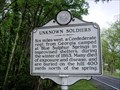
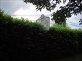
|   Unknown Soldiers Unknown Soldiers
in West Virginia Historical Markers Tells you why Confederate soldiers died near here. posted by:  Paintedwarrior Paintedwarrior location: West Virginia date approved: 05/11/2012 last visited: 05/13/2012 |
 view gallery view gallery N7.9 km N7.9 km
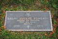
|  Ralph Eugene Pomeroy - Smoot, WV Ralph Eugene Pomeroy - Smoot, WV
in Medal Of Honor Resting Places Ralph E.Pomeroy was awarded the Medal of Honor for his actions during the Korean War. posted by: Sneakin Deacon location: West Virginia date approved: 11/28/2011 last visited: never |
 view gallery view galleryN8.2 km |  Sam Black Church - Smoot, WV Sam Black Church - Smoot, WV
in U.S. National Register of Historic Places The historic Sam Black Church stands on Route 60 near the Intersection of Interstate 64. posted by: Sneakin Deacon location: West Virginia date approved: 11/28/2011 last visited: never |
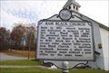 view gallery view galleryN8.2 km | Sam Black Church in West Virginia Historical Markers This historic marker stands in front of the Sam Black United Methodist Church near Smoot, West Virginia posted by: Sneakin Deacon location: West Virginia date approved: 11/28/2011 last visited: 05/10/2014 |
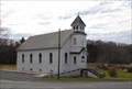 view gallery view galleryN8.2 km |  Sam Black Church - Smoot, WV Sam Black Church - Smoot, WV
in Country Churches Sam Black Church is located on U. S. Route 60 in the unincorporated community of Smoot, West Virginia posted by: Sneakin Deacon location: West Virginia date approved: 11/29/2011 last visited: never |
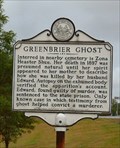 view gallery view galleryN8.4 km | Greenbrier Ghost in West Virginia Historical Markers Greenbrier Ghost, near Sam Black Church posted by:  two-bit Joe two-bit Joe location: West Virginia date approved: 08/28/2006 last visited: 05/10/2014 |
 view gallery view galleryN8.4 km |  Greenbrier Ghost Greenbrier Ghost
in Weird Story Locations Greenbrier Ghost Greenbrier County, WV posted by: two-bit Joe location: West Virginia date approved: 01/23/2006 last visited: 05/10/2014 |
 view gallery view gallery NE9.5 km NE9.5 km
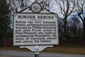
| Border Heros in West Virginia Historical Markers This historic marker stand at the intersection of Route 60 and Old State Rt. 12 in Greenbrier County. posted by: Sneakin Deacon location: West Virginia date approved: 11/28/2011 last visited: never |
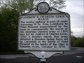 view gallery view galleryNE9.5 km | Andrew & Charles Lewis March in West Virginia Historical Markers A sign telling us about a march of the American Colonial army and the out come of the battle at Point Pleasant. posted by: Paintedwarrior location: West Virginia date approved: 05/19/2014 last visited: 05/20/2014 |
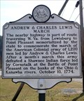 view gallery view galleryE9.7 km | Andrew & Charles Lewis March in West Virginia Historical Markers Marker commemorating the route of Lewis' army to the Battle of Point Pleasant. posted by: SportsPhotoGuy location: West Virginia date approved: 02/20/2009 last visited: 11/09/2011 |
 view gallery view gallery S10.6 km S10.6 km
| Greenbrier County / Summers County in West Virginia Historical Markers A two sided sign telling us where the counties were formed from and what they were named after. posted by: dukemartin location: West Virginia date approved: 10/05/2018 last visited: never |
 view gallery view galleryS10.8 km | Alderson Baptist Academy and Junior College in West Virginia Historical Markers A sign telling us some of the history of the school once located here. posted by: dukemartin location: West Virginia date approved: 10/05/2018 last visited: never |
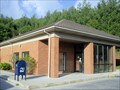 view gallery view galleryN10.9 km |  Crawley, WV, 24931, Post Office Crawley, WV, 24931, Post Office
in U.S. Post Offices Crawley, West Virginia, 24931, Post Office posted by: dukemartin location: West Virginia date approved: 05/08/2012 last visited: never |
 view gallery view galleryS11.1 km | Alderson in West Virginia Historical Markers Tells about the first Baptist Church in the Greenbrier Valley. posted by: Paintedwarrior location: West Virginia date approved: 05/11/2012 last visited: 05/13/2012 |
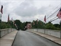
 view gallery view galleryS11.1 km |  Alderson Memorial Bridge History - Alderson WV Alderson Memorial Bridge History - Alderson WV
in Signs of History The marker is attached to the bridge at 100 N Monroe St, Alderson WV 24910 posted by: Don.Morfe location: West Virginia date approved: 10/05/2023 last visited: 10/05/2023 |
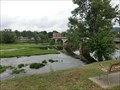 view gallery view galleryS11.3 km |  Alderson Bridge - Alderson WV Alderson Bridge - Alderson WV
in Arch Bridges The Alderson Bridge, also known as Alderson Memorial Bridge, is a historic concrete arch bridge in Alderson, West Virginia. It crosses the Greenbrier River, which separates Greenbrier and Monroe counties. posted by: Don.Morfe location: West Virginia date approved: 10/05/2023 last visited: 10/05/2023 |
 view gallery view galleryS11.3 km |  Alderson Bridge - Alderson WV Alderson Bridge - Alderson WV
in Wikipedia Entries The Alderson Bridge, also known as Alderson Memorial Bridge, is a historic concrete arch bridge in Alderson, West Virginia. It crosses the Greenbrier River, which separates Greenbrier and Monroe counties. posted by: Don.Morfe location: West Virginia date approved: 10/05/2023 last visited: 10/05/2023 |
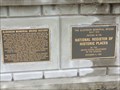
 view gallery view galleryS11.3 km | Alderson Bridge - Alderson WV in U.S. National Register of Historic Places The Alderson Bridge, also known as Alderson Memorial Bridge, is a historic concrete arch bridge in Alderson, West Virginia. It crosses the Greenbrier River, which separates Greenbrier and Monroe counties. posted by: Don.Morfe location: West Virginia date approved: 10/05/2023 last visited: 10/05/2023 |
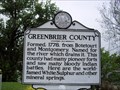 view gallery view galleryS11.3 km | Greenbrier County Monroe County in West Virginia Historical Markers A two sided sign telling were the counties were formed from and what they were named after. posted by: Paintedwarrior location: West Virginia date approved: 05/11/2012 last visited: 05/13/2012 |
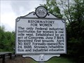 view gallery view galleryS11.3 km | Reformatory For Women in West Virginia Historical Markers Tells about an institution to reform women. posted by: Paintedwarrior location: West Virginia date approved: 05/11/2012 last visited: 05/13/2012 |
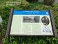
 view gallery view galleryS11.3 km |  Alderson's Ferry-Strategic Crossing - Alderson WV Alderson's Ferry-Strategic Crossing - Alderson WV
in U.S. Civil War Sites During the Civil War, the ferry played a significant role as both Union and Confederate forces used it to carry men and supplies across the river here. On June 22, 1862, 1,600 Federal troops were ferried over the river here on an expeditiion. posted by: Don.Morfe location: West Virginia date approved: 07/01/2023 last visited: 07/01/2023 |
 view gallery view galleryS11.3 km | Aldersons Ferry-Strategic Crossing - Alderson WV in Civil War Discovery Trail Sites Here, where you are standing, you can see both sides of the Greenbrier River where Alderson’s Ferry crossed. posted by: Don.Morfe location: West Virginia date approved: 03/10/2020 last visited: 10/08/2021 |
 view gallery view galleryS11.3 km |  Skirmish at Alderson's Ferry - Alderson WV Skirmish at Alderson's Ferry - Alderson WV
in Battlefields Because of the importance of the ferry, occasionally engagements were fought here as each side sought to control the crossing or deny the ferry’s use to the enemy. posted by: Don.Morfe location: West Virginia date approved: 11/21/2020 last visited: 10/16/2021 |
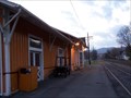 view gallery view galleryS11.3 km |  Alderson Depot - Alderson, WV Alderson Depot - Alderson, WV
in Train Stations/Depots C&O depot in Alderson, West Virginia. posted by: bitmapped location: West Virginia date approved: 07/31/2008 last visited: 11/04/2007 |
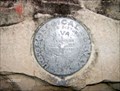 view gallery view galleryS11.3 km |  1556 USGS 1556 USGS
in U.S. Benchmarks DESCRIBED BY NATIONAL GEODETIC SURVEY 1958 AT ALDERSON. AT ALDERSON, 0.1 MILE EAST ALONG THE CHESAPEAKE AND OHIO RAILWAY FROM THE STATION, AT THE INTERSECTION OF RAILROAD AVENUE AND SOUTH MONROE STREET, SET VERTICALLY IN THE WEST FACE OF STONE WATER TABLE OF QUILLEN LUMBER AND SUPPLY COMPANY (THREE-STORY BRICK BUILDING), 46 1/2 FEET SOUTH OF THE SOUTH RAIL OF THE SOUTH MAIN TRACK, 33 FEET SOUTH OF THE SOUTH RAIL OF SIDE TRACK, 10.2 FEET EAST OF EAST CURB OF STREET, 47 FEET NORTH OF THE PROLONGAT posted by: AK-Jeff location: West Virginia date approved: 12/05/2007 last visited: 11/01/2010 |
|