 view gallery view gallery SW1.6 km SW1.6 km
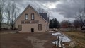
|   Enoch Schoolhouse and Tithing Office ~ 480 Enoch Schoolhouse and Tithing Office ~ 480
in D.U.P. Historic Markers The schoolhouse and Tithing Office both served important functions in early Mormon settlements. posted by:  brwhiz brwhiz location: Utah date approved: 04/11/2011 last visited: never |
 view gallery view gallerySW1.6 km |  Enoch Schoolhouse and Tithing Office Enoch Schoolhouse and Tithing Office
in Utah Historical Markers The second schoolhouse in Enoch was a two-story structure built on this site in 1917-1918. It was a brick building containing two classrooms, two libraries, two bathrooms and a furnace room....
posted by: JacobBarlow location: Utah date approved: 10/02/2007 last visited: 01/29/2011 |
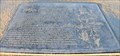
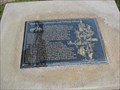
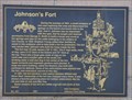 view gallery view gallerySW1.9 km | Johnson's Fort ~ 461 in D.U.P. Historic Markers Johnson's Fort was one of the earliest fortified settlements in southwestern Utah. posted by: brwhiz location: Utah date approved: 01/16/2012 last visited: never |
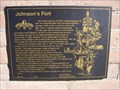 view gallery view gallerySW2.1 km | Johnson's Fort in Utah Historical Markers During the summer of 1851, a small company of men was exploring this area and discovered the springs on the bench one-fourth mile to the east.... posted by: JacobBarlow location: Utah date approved: 10/02/2007 last visited: 01/29/2011 |
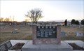 view gallery view gallery S2.1 km S2.1 km
|  Enoch City Veterans Memorial Enoch City Veterans Memorial
in Non-Specific Veteran Memorials This Veterans Memorial is located in the Enoch City Cemetery at 4980 N 1600 East in Enoch, Utah. posted by: brwhiz location: Utah date approved: 04/03/2013 last visited: never |
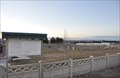 view gallery view galleryS2.1 km |  Enoch City Cemetery Enoch City Cemetery
in Worldwide Cemeteries This Cemetery is located at 4980 N 1600 East in Enoch, Utah. posted by: brwhiz location: Utah date approved: 04/03/2013 last visited: never |
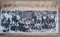
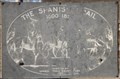
 view gallery view gallerySW3.4 km | Old Spanish Trail - Enoch, UT in Utah Historical Markers This marker was originally created in 1948. posted by: rjmcdonough1 location: Utah date approved: 10/12/2019 last visited: never |
 view gallery view gallerySW3.4 km |  Old Spanish Trail Marker - Enoch, UT Old Spanish Trail Marker - Enoch, UT
in Eagle Scout Project Sites This project updated a historic marker originally created by a Boy Scout troop in 1948. posted by: rjmcdonough1 location: Utah date approved: 09/06/2019 last visited: never |
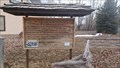
 view gallery view gallerySW3.4 km |  Old School Library - Enoch, UT Old School Library - Enoch, UT
in Libraries The Old School Library serves Enoch, Utah. posted by: The Snowdog location: Utah date approved: 01/02/2023 last visited: never |
 view gallery view gallerySW3.4 km |  Old Spanish Trail Sign - Enoch, Utah Old Spanish Trail Sign - Enoch, Utah
in Photos Then and Now This sign was erected by the Boy Scouts in 1948, and exhibits a photograph of the then-new sign - in Enoch, Utah. posted by: The Snowdog location: Utah date approved: 01/02/2023 last visited: never |
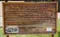
 view gallery view gallerySW3.4 km |  First Wagons on the Old Spanish Trail - Enoch, UT First Wagons on the Old Spanish Trail - Enoch, UT
in Wagon Roads and Trails The first wagon to enter Iron County on the Old Spanish Trail arrived in 1848 - in Enoch, Utah. posted by: The Snowdog location: Utah date approved: 01/03/2023 last visited: never |
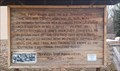 view gallery view gallerySW3.4 km |  First Wagon on the Old Spanish Trail - 100 Years - Enoch, UT First Wagon on the Old Spanish Trail - 100 Years - Enoch, UT
in Commercial Commemorations This sign, created by the Boy Scouts in 1948, commemorates the arrival of the first wagons on the Old Spanish Trail one hundred years earlier - in Enoch, Utah. posted by: The Snowdog location: Utah date approved: 01/23/2023 last visited: never |
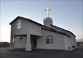 view gallery view galleryS3.9 km |  Red Hills Southern Baptist Church - Enoch, UT Red Hills Southern Baptist Church - Enoch, UT
in Baptist Churches This Baptist Church is located at 4277 N Wagon Wheel Drive in Enoch, Utah. posted by: brwhiz location: Utah date approved: 04/02/2013 last visited: never |
 view gallery view gallery E7.4 km E7.4 km
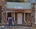
|  Summit, Utah 84772 Summit, Utah 84772
in U.S. Post Offices This Post Office is located at 127 E Main Street in Summit, Utah. It appears to be housed in a very old filling station and garage and sits alongside old US Highway 91 which used to be the main route through this area. posted by: brwhiz location: Utah date approved: 01/16/2012 last visited: 01/13/2012 |
 view gallery view galleryE7.4 km |  Summit, Utah Summit, Utah
in Wikipedia Entries Summit is one of those places that if you blink, you miss it. The wikipedia entry says very little about Summit, but it seems to say all there is to say! posted by: brwhiz location: Utah date approved: 04/15/2011 last visited: never |
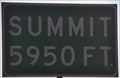 view gallery view galleryE7.4 km |  Southbound Interstate 15 - Summit at Summit, Utah ~ Elevation 5950 feet Southbound Interstate 15 - Summit at Summit, Utah ~ Elevation 5950 feet
in Elevation Signs This minor summit along Interstate 15 occurs just west of the small community of Summit. posted by: brwhiz location: Utah date approved: 03/13/2012 last visited: 03/25/2016 |
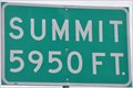 view gallery view galleryE7.4 km | Northbound Interstate 15 - Summit at Summit, Utah ~ Elevation 5950 feet in Elevation Signs This minor summit along Interstate 15 occurs just west of the small community of Summit. posted by: brwhiz location: Utah date approved: 03/27/2012 last visited: 03/25/2016 |
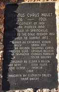 view gallery view galleryE7.4 km | Sylvanus Cyrus Hulet in Utah Historical Markers Sylvanus Cyrus Hulet was a prominent member of the community of Summit during its early years and the first bishop of the Summit Ward. posted by: brwhiz location: Utah date approved: 04/12/2011 last visited: never |
 view gallery view galleryE7.6 km | The Spanish Trail in Utah Historical Markers This Historical Marker is located on the north side of Main Street (Old US Highway 91) at the southeast corner of the LDS Church grounds in Summit, Utah. posted by: brwhiz location: Utah date approved: 04/12/2013 last visited: never |
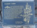 view gallery view gallerySW8.2 km | Pioneer Cabin in Utah Historical Markers This is the oldest log cabin in Southern Utah. It was built in 1851 in Parowan by George Wood, one of the founders of Iron County... posted by: JacobBarlow location: Utah date approved: 10/02/2007 last visited: 11/22/2009 |
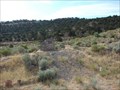 view gallery view galleryS10.5 km | First Cedar Encampment in Utah Historical Markers Iron ore having been discovered at Iron Springs, Brigham Young called missionaries to Iron County to make iron. posted by: JacobBarlow location: Utah date approved: 08/11/2007 last visited: 04/18/2023 |
 view gallery view galleryS10.5 km |  First Settler Encampment at Cedar City First Settler Encampment at Cedar City
in First of its Kind The first encampment at Cedar City was established during a snowstorm in November of 1851. posted by: brwhiz location: Utah date approved: 04/08/2011 last visited: 04/18/2023 |
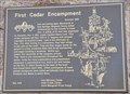 view gallery view galleryS10.5 km | First Cedar Encampment ~ 418 in D.U.P. Historic Markers The first encampment at Cedar City was established during a snowstorm in November of 1851. posted by: brwhiz location: Utah date approved: 04/11/2011 last visited: 04/18/2023 |
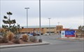 view gallery view gallerySW10.5 km |  Valley View Medical Center ~ Cedar City, Utah Valley View Medical Center ~ Cedar City, Utah
in Hospitals This Hospital is located at 1303 N Main Street in Cedar City, Utah. posted by: brwhiz location: Utah date approved: 04/07/2013 last visited: 08/05/2014 |
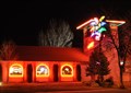 view gallery view galleryS11.1 km |  La Fiesta - Cedar City, Utah La Fiesta - Cedar City, Utah
in Neon Signs This neon sign in front of La Fiesta Mexican Restaurant in Cedar City is an animated sign. The "fronds" of the palm tree light up in sequence and then go out to start the sequence again. posted by: brwhiz location: Utah date approved: 03/09/2011 last visited: 01/30/2012 |
|