 view gallery view gallery W11.4 km W11.4 km
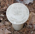
|   LS1611 Missouri Land Survey 1979 LS1611 Missouri Land Survey 1979
in U.S. Benchmarks Missouri Land Survey mark near Hawn State Park. posted by:  dcrep dcrep location: Missouri date approved: 03/23/2008 last visited: never |
 view gallery view gallery NE11.9 km NE11.9 km
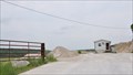
|  Fischer Brothers Quarry Fischer Brothers Quarry
in Active Quarries This Active Quarry is located at 25501 State Route Z, approximately 3.5 miles west of St. Mary, Missouri. Coordinates were taken at the entrance gate. posted by:  brwhiz brwhiz location: Missouri date approved: 07/02/2013 last visited: never |
 view gallery view gallery NW15.3 km NW15.3 km
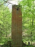
|  Camp Weingarten - Weingarten, Missouri Camp Weingarten - Weingarten, Missouri
in WWII Prisoner of War Camps Camp Weingarten was of of four main P.O.W. camps in Missouri during World War II. The only remains of the camp is this lonely chimney from the officers club, for the officers running the camp.
posted by:  BruceS BruceS location: Missouri date approved: 05/07/2008 last visited: 12/26/2011 |
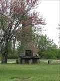 view gallery view galleryNW15.3 km |  Officers Club Chimney, Camp Weingarten- Weingarten, Missouri Officers Club Chimney, Camp Weingarten- Weingarten, Missouri
in Lonely Chimneys Camp Weingarten was one of four main P.O.W. camps in Missouri during World War II. The only remains of the camp is this lonely chimney from the officers club, for the officers running the camp. posted by: BruceS location: Missouri date approved: 05/07/2008 last visited: never |
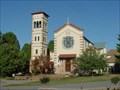
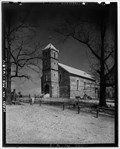 view gallery view galleryNW15.9 km |  Our Lady Help of Christians Catholic Church - Weingarten, Missouri Our Lady Help of Christians Catholic Church - Weingarten, Missouri
in Photos Then and Now Catholic church in small German community of Weingarten, Missouri. posted by: BruceS location: Missouri date approved: 05/20/2008 last visited: never |
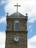 view gallery view galleryNW15.9 km |  Our Lady Help of Christians Catholic Church Clock - Weingarten, Missouri Our Lady Help of Christians Catholic Church Clock - Weingarten, Missouri
in Town Clocks Clock in the tower of a Catholic church in small German community of Weingarten, Missouri. posted by: BruceS location: Missouri date approved: 05/22/2008 last visited: never |
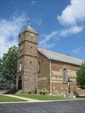 view gallery view galleryNW15.9 km |  Our Lady Help of Christians Catholic Church - Weingarten, Missouri Our Lady Help of Christians Catholic Church - Weingarten, Missouri
in This Old Church Catholic church in small German community of Weingarten, Missouri. posted by: BruceS location: Missouri date approved: 05/20/2008 last visited: never |
 view gallery view galleryNW15.9 km | Our Lady Help of Christians Catholic Church - Weingarten, Missouri in Roman Catholic Churches Catholic church in small German community of Weingarten, Missouri. posted by: BruceS location: Missouri date approved: 05/22/2008 last visited: never |
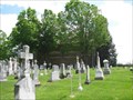
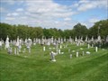 view gallery view galleryNW15.9 km |  Our Lady Help of Christians Catholic Cemetery - Weingarten, Missouri Our Lady Help of Christians Catholic Cemetery - Weingarten, Missouri
in Worldwide Cemeteries Catholic cemetery in small German community of Weingarten, Missouri. posted by: BruceS location: Missouri date approved: 05/20/2008 last visited: never |
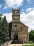
 view gallery view galleryNW15.9 km |  Our Lady Help of Christians Catholic Church and Cemetery - Weingarten, Missouri Our Lady Help of Christians Catholic Church and Cemetery - Weingarten, Missouri
in Churchyard Cemeteries Catholic church and cemetery in small German community of Weingarten, Missouri. posted by: BruceS location: Missouri date approved: 05/22/2008 last visited: never |
 view gallery view galleryNE16.6 km |  Saint Mary, Missouri 63673 Saint Mary, Missouri 63673
in U.S. Post Offices This Post Office is located at 676 2nd Street in Saint Mary, Missouri. posted by: brwhiz location: Missouri date approved: 06/26/2013 last visited: never |
 view gallery view galleryNW16.6 km | Sawmill Road Chimney - Weingarten, Missouri in Lonely Chimneys Brick chimney along country road called Sawmill Road near Weingarten, Missouri. posted by: BruceS location: Missouri date approved: 05/20/2008 last visited: never |
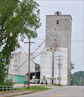 view gallery view galleryNE16.6 km |  MFA Agri Services River Hills Elevator MFA Agri Services River Hills Elevator
in Grain Elevators This Grain Elevator is located at 677 2nd Street in Saint Marys, Missouri. posted by: brwhiz location: Missouri date approved: 07/03/2013 last visited: never |
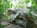 view gallery view galleryW17.9 km |  Terrapin Rock - Pickle Springs Natural Area - Ste. Genevieve County, Missouri Terrapin Rock - Pickle Springs Natural Area - Ste. Genevieve County, Missouri
in Simulacra Terrapin rock is a rock in the shape of a terrapin type turtle located along the "Trail Through Time" at the Pickle Springs Natural Area.
posted by: BruceS location: Missouri date approved: 01/12/2009 last visited: never |
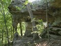 view gallery view galleryW17.9 km |  Double Arch, Pickle Springs Natural Area, Farmington, Missouri Double Arch, Pickle Springs Natural Area, Farmington, Missouri
in Natural Arches Nice double arch located in Pickle Springs Natural Area. posted by: paulspaper location: Missouri date approved: 09/15/2008 last visited: 12/03/2010 |
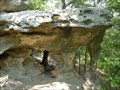 view gallery view galleryW17.9 km |  Pickle Springs Natural Area, Farmington, Missouri Pickle Springs Natural Area, Farmington, Missouri
in U.S. National Natural Landmarks Pickle Springs Natural Area features many outstanding natural features. posted by: paulspaper location: Missouri date approved: 09/15/2008 last visited: 09/08/2009 |
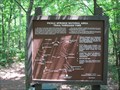
 view gallery view galleryW18.2 km |  Trail Through Time You Are Here Map - Ste. Genevieve County, Missouri Trail Through Time You Are Here Map - Ste. Genevieve County, Missouri
in 'You Are Here' Maps A your are here map at the trail head of Trail Through Time at the Pickle Springs Natural Area which is listed as a National Natural Landmark. posted by: BruceS location: Missouri date approved: 01/04/2009 last visited: 09/08/2009 |
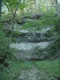
 view gallery view galleryW18.2 km |  Pickle Springs Natural Area - Trail Through Time - Ste. Genevieve County, Missouri Pickle Springs Natural Area - Trail Through Time - Ste. Genevieve County, Missouri
in Self Guided Walks and Trails Self guided nature walk through the Pickle Springs Natural Area which is listed as a National Natural Landmark.
posted by: BruceS location: Missouri date approved: 01/03/2009 last visited: 09/08/2009 |
 view gallery view galleryW18.2 km |  Pickle Springs Natural Area - Trail Through Time - Ste. Genevieve County, Missouri Pickle Springs Natural Area - Trail Through Time - Ste. Genevieve County, Missouri
in Hiking and walking trailheads Self guided nature trail through the Pickle Springs Natural Area which is listed as a National Natural Landmark. posted by: BruceS location: Missouri date approved: 01/11/2009 last visited: 09/08/2009 |
 view gallery view gallery E18.2 km E18.2 km
|  Ball Mill Resurgence Pit - Missouri Ball Mill Resurgence Pit - Missouri
in Places of Geologic Significance Ball Mill Resurgence Pit is a large sinkhole resurgence pit. posted by: paulspaper location: Missouri date approved: 04/07/2008 last visited: 06/08/2007 |
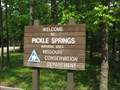 view gallery view galleryW18.2 km |  Pickle Springs Natural Area - Ste. Genevieve County, Missouri Pickle Springs Natural Area - Ste. Genevieve County, Missouri
in Public Access Lands Pickle Springs Natural Area which is listed as a National Natural Landmark is managed by the Missouri Department of Conservation.
posted by: BruceS location: Missouri date approved: 01/06/2009 last visited: never |
 view gallery view galleryE18.5 km |  Ball Mill Resurgence Pit - Perryville, MO Ball Mill Resurgence Pit - Perryville, MO
in Natural Sinkholes Ball Mill Resurgence Pit, located along County Road 914 in the northern portion of Perry County is a large sinkhole resurgence pit. posted by: paulspaper location: Missouri date approved: 04/18/2008 last visited: 06/08/2007 |
 view gallery view gallery N18.8 km N18.8 km
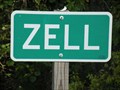
|  Zell, Missouri Zell, Missouri
in 'Z' Welcome Signs Zell is a tiny community near Ste. Genevieve, Missouri. posted by: paulspaper location: Missouri date approved: 09/15/2008 last visited: never |
 view gallery view galleryE19.2 km |  St. Mary's of the Barrens Historic District - Perryville, Missouri St. Mary's of the Barrens Historic District - Perryville, Missouri
in U.S. National Register of Historic Places Historic district with church, shrine, Vincentian Community Cemetery, Grotto of Our Lady of the Miraculous Medal, Rosati's Cabin and visitors center. posted by: paulspaper location: Missouri date approved: 10/22/2007 last visited: never |
 view gallery view galleryE19.2 km | St. Mary's of the Barrens Church - Perryville, Missouri in This Old Church Replica of the Vincentian Motherhouse Church in Rome, Monte Citorio. Construction began in 1827 and today it houses the National Shrine to Our Lady of the Miraculous Medal.
posted by: paulspaper location: Missouri date approved: 10/20/2007 last visited: never |
|