  SW5.1 km SW5.1 km
|   Lodestar Lightning Lodestar Lightning
in Plane Crash Sites In 1977 a Lockheed Lodestar, laden with tons of marijuana, crashed at Lower Merced Pass Lake in the remote backcountry of Yosemite National Park. The incident in 1977 was the inspiration for Nevada Barr's national best selling book, "High Country". The true story is almost stranger than fiction. posted by:  Touchstone Touchstone location: California date approved: 03/04/2006 last visited: never |
 view gallery view gallery NW13 km NW13 km
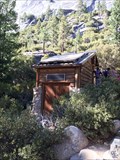
|  Solar Bathroom - Yosemite, CA Solar Bathroom - Yosemite, CA
in Solar Power A remote restroom near Nevada Falls with solar power. posted by: bluesnote location: California date approved: 01/11/2017 last visited: 01/11/2017 |
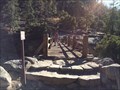
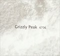 view gallery view galleryNW13 km |  Vernal/Nevada Falls Trails (Nevada Falls) - Grizzly Peak 6706 ft. - Yosemite, CA Vernal/Nevada Falls Trails (Nevada Falls) - Grizzly Peak 6706 ft. - Yosemite, CA
in Elevation Signs One of a few maps located within Yosemite. posted by: bluesnote location: California date approved: 07/07/2017 last visited: 07/07/2017 |
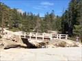 view gallery view galleryNW13.2 km |  Nevada Falls Bridge - Yosemite, CA Nevada Falls Bridge - Yosemite, CA
in Hiking Path Footbridges About 5 miles from Glacier Point, 4 miles from Curry Village, and 9 miles form Half Dome. posted by: bluesnote location: California date approved: 01/11/2017 last visited: 01/11/2017 |
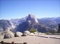
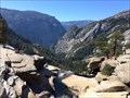 view gallery view galleryNW13.2 km |  Nevada Falls Overlook - Yosemite, CA Nevada Falls Overlook - Yosemite, CA
in Scenic Overlooks A huge overlook at the top of Nevada Falls. posted by: bluesnote location: California date approved: 11/07/2017 last visited: 11/07/2017 |
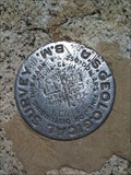 view gallery view galleryNW13.2 km |  Nevada Falls Overlook, Yosemite Valley Nevada Falls Overlook, Yosemite Valley
in U.S. Benchmarks Located on the overlook above Nevada Falls in Yosemite Valley, this benchmark will take approximately three miles of hiking to reach, but the commanding views are well worth the effort. posted by: Touchstone location: California date approved: 09/20/2006 last visited: 01/26/2015 |
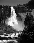
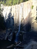
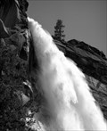 view gallery view galleryNW13.2 km |  Nevada Falls - Yosemite, CA Nevada Falls - Yosemite, CA
in Photos Then and Now An extremely challenging hike to get here, but very rewarding once you see it in person. posted by: bluesnote location: California date approved: 11/21/2017 last visited: 11/20/2017 |
 view gallery view galleryNW13.2 km |  Nevada Falls - Yosemite, CA Nevada Falls - Yosemite, CA
in Wikipedia Entries An extremely challenging hike to get here, but very rewarding once you see it in person. posted by: bluesnote location: California date approved: 01/14/2017 last visited: 01/14/2017 |
 view gallery view galleryNW13.2 km |  Nevada Falls - Yosemite, CA Nevada Falls - Yosemite, CA
in Waterfalls An extremely challenging hike to get here, but very rewarding once you see it in person. posted by: bluesnote location: California date approved: 01/12/2017 last visited: 01/12/2017 |
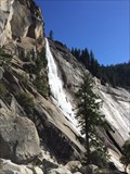 view gallery view galleryNW13.2 km |  Nevada Falls - Yosemite, CA Nevada Falls - Yosemite, CA
in Official Local Tourism Attractions An extremely challenging hike to get here, but very rewarding once you see it in person. posted by: bluesnote location: California date approved: 11/08/2017 last visited: 11/08/2017 |
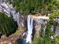
 view gallery view galleryNW13.4 km | Detail view of Nevada Falls in Yosemite National Park in Ansel Adams Photo Hunt Another location where Ansel Adams photographed Nevada Falls in Yosemite National Park - Image made April 22, 2013 posted by:  05auditt 05auditt location: California date approved: 05/19/2013 last visited: 09/24/2016 |
 view gallery view galleryNW13.4 km | Liberty Cap - Yosemite, CA in Wikipedia Entries A tall granite dome located near the base of Nevada Falls. posted by: bluesnote location: California date approved: 01/14/2017 last visited: 01/14/2017 |
 view gallery view galleryNW13.4 km | Liberty Cap - Yosemite, CA in Official Local Tourism Attractions A tall granite dome located near the base of Nevada Falls. posted by: bluesnote location: California date approved: 11/08/2017 last visited: 11/08/2017 |
 view gallery view galleryNW13.5 km | Nevada Falls Yosemite National Park in Ansel Adams Photo Hunt Location where Ansel Adams photographed Nevada Falls in Yosemite National Park - Image made April 22, 2013 posted by: 05auditt location: California date approved: 05/17/2013 last visited: 09/24/2016 |
 view gallery view galleryNW13.8 km | Vernal Falls Bridge - Yosemite, CA in Hiking Path Footbridges A bridge just above Vernal Falls along the John Muir Trail in Yosemite National Park. posted by: bluesnote location: California date approved: 01/11/2017 last visited: 01/11/2017 |
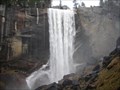 view gallery view galleryNW14.2 km | Vernal Falls in Waterfalls Beautiful waterfall at Yosemite National Park. posted by: TeamZombie location: California date approved: 04/13/2007 last visited: 09/24/2016 |
 view gallery view galleryNW14.2 km | Yosemite Vernal Falls overlook USGS BM in Scenic Overlooks On the return trail (upper elevation) from Vernal Falls I found this BM marker just behind a small ledge/overlook about 20-25 feet north of the John Muir trail, east of Clark Point. posted by: Golfman1959 location: California date approved: 08/27/2010 last visited: 09/24/2016 |
 view gallery view galleryNW14.2 km | Vernal Falls - Yosemite, CA in Official Local Tourism Attractions The first major waterfall along the John Muir Trail in Yosemite National Park. posted by: bluesnote location: California date approved: 11/08/2017 last visited: 11/08/2017 |
 view gallery view galleryNW14.2 km |  Vernal Falls - Yosemite, CA Vernal Falls - Yosemite, CA
in Satellite Imagery Oddities The first major waterfall along the John Muir Trail in Yosemite National Park. posted by: bluesnote location: California date approved: 01/11/2017 last visited: 01/11/2017 |
 view gallery view galleryNW14.2 km | Vernal Falls - Yosemite, CA in Wikipedia Entries The first major waterfall along the John Muir Trail in Yosemite National Park. posted by: bluesnote location: California date approved: 01/14/2017 last visited: 01/14/2017 |
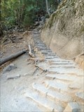 view gallery view galleryNW14.2 km |  John Muir Trail - Yosemite, CA John Muir Trail - Yosemite, CA
in Outdoor Stairways For over a mile, between Curry Village and Nevada Falls, you will be climbing stairs up to Vernal then Nevada Falls. posted by: bluesnote location: California date approved: 01/17/2017 last visited: 01/17/2017 |
 view gallery view galleryNW14.6 km |  Half Dome - Yosemite, CA Half Dome - Yosemite, CA
in American Guide Series Half Dome in Yosemite National Park. posted by: bluesnote location: California date approved: 11/14/2017 last visited: 05/03/2022 |
 view gallery view galleryNW14.6 km | Half Dome - Yosemite, CA in Wikipedia Entries Half Dome in Yosemite National Park. posted by: bluesnote location: California date approved: 01/14/2017 last visited: 08/01/2023 |
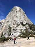
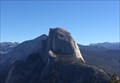
 view gallery view galleryNW14.6 km |  Half Dome Half Dome
in Mountain Summits An iconic mountain in Yosemite Valley. It's hard to go through the gift shops in Yosemite Valley without seeing the image of this mountain emblazoned on t-shirts, coffee mugs and even shot glasses. Indeed, the National Park Service is so enamored of this mountain that they use a graphic designed silhouette of this mountain as their logo to represent the Park.
posted by: Touchstone location: California date approved: 09/20/2006 last visited: 08/01/2023 |
 view gallery view galleryNW14.6 km | Half Dome - Yosemite, CA in Official Local Tourism Attractions Half Dome in Yosemite National Park. posted by: bluesnote location: California date approved: 11/08/2017 last visited: 08/01/2023 |
|