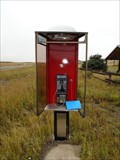
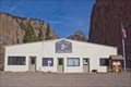
 view gallery view gallery NE11.7 km NE11.7 km
|   Highway 149 Payphone - Creede, CO Highway 149 Payphone - Creede, CO
in Payphones Lonely payphone on highway 149. posted by:  LT_Dream LT_Dream location: Colorado date approved: 09/13/2015 last visited: 08/14/2017 |
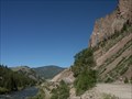
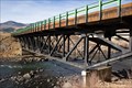 view gallery view galleryNE19.2 km |  Sevenmile Bridge - Creede, CO Sevenmile Bridge - Creede, CO
in U.S. National Register of Historic Places Constructed in 1935 and listed on the national register in 1985, this historic highway bridge now provides access to a Forest Service campground. posted by: IJAdventures location: Colorado date approved: 11/26/2012 last visited: never |
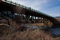 view gallery view galleryNE19.2 km |  Sevenmile Bridge - Creede, CO Sevenmile Bridge - Creede, CO
in Truss Bridges This bridge is one of only 9 deck trusses in Colorado and was listed on the National Register of Historic Places in 1985. posted by: IJAdventures location: Colorado date approved: 11/24/2012 last visited: never |
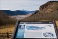
 view gallery view gallery N22.9 km N22.9 km
|  "You Are Here" at Browns Lake Overlook - Rio Grande National Forest, CO "You Are Here" at Browns Lake Overlook - Rio Grande National Forest, CO
in 'You Are Here' Maps You are near the headwaters of the Rio Grande River overlooking Brown's Lake and Rio Grande Pyramid (13,821 ft). posted by: IJAdventures location: Colorado date approved: 11/30/2012 last visited: 09/07/2015 |
 view gallery view galleryN22.9 km |  Headwaters of the Rio Grande Orientation Table - Rio Grande National Forest, CO Headwaters of the Rio Grande Orientation Table - Rio Grande National Forest, CO
in Orientation Tables An orientation table located at Browns Lake Overlook near the headwaters of the Rio Grande River. posted by: IJAdventures location: Colorado date approved: 12/01/2012 last visited: 09/07/2015 |
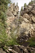
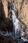 view gallery view galleryN23.3 km |  North Clear Creek Falls - Rio Grande National Forest, CO North Clear Creek Falls - Rio Grande National Forest, CO
in Waterfalls This picturesque waterfall offers a spectacular view any time of the year. posted by: IJAdventures location: Colorado date approved: 12/01/2012 last visited: 09/07/2015 |
 view gallery view galleryN25.7 km |  Moose Overlook - Rio Grande National Forest, CO Moose Overlook - Rio Grande National Forest, CO
in Scenic Roadside Look-Outs If you look carefully, you may spot a moose in the field nearby. posted by: IJAdventures location: Colorado date approved: 12/03/2012 last visited: 09/07/2015 |
 view gallery view gallery W26.9 km W26.9 km
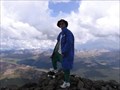
|  Rio Grande Pyramid Rio Grande Pyramid
in Mountain Summits A class II jaunt up a mountain in the Weminuche Wilderness. There are excellent views to the west of Windom, Sunlight, The Guardian and other imposing peaks. Interesting perspective of the Window formation to the south, and nice vistas to the north and east. posted by:  krazykatzen krazykatzen location: Colorado date approved: 10/02/2006 last visited: never |
 view gallery view galleryNE26.9 km |  Creede Fork - Creede, CO Creede Fork - Creede, CO
in Ginormous Everyday Objects You can't miss this fork in the road. posted by: IJAdventures location: Colorado date approved: 11/17/2012 last visited: 08/05/2014 |
 view gallery view galleryNE26.9 km |  40 Foot Long Fork - Creede, CO 40 Foot Long Fork - Creede, CO
in Roadside Attractions Made of aluminum, the Creede Fork is one of the largest in the world. posted by: IJAdventures location: Colorado date approved: 11/15/2012 last visited: 08/05/2014 |
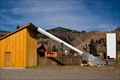
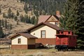 view gallery view galleryNE26.9 km | Wagon Wheel Gap Railroad Station - Creede, CO in U.S. National Register of Historic Places Connecting the mountain mining towns to the San Luis Valley, this depot sits as a reminder of the golden days of rail travel. posted by: IJAdventures location: Colorado date approved: 11/09/2012 last visited: never |
 view gallery view galleryNE26.9 km |  Wagon Wheel Gap Railroad Station - Creede, CO Wagon Wheel Gap Railroad Station - Creede, CO
in Train Stations/Depots An historic railroad station between South Fork and Creede, now a private residence. posted by: IJAdventures location: Colorado date approved: 11/09/2012 last visited: never |
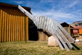
 view gallery view galleryNE27.2 km |  Four Seasons of Mineral County - Creede, CO Four Seasons of Mineral County - Creede, CO
in Murals This mural by Stephen Quiller is located on the north side of the Elks Building on Main Street. posted by: IJAdventures location: Colorado date approved: 11/14/2012 last visited: never |
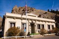 view gallery view galleryNE27.4 km |  Mineral County Courthouse - Creede, CO Mineral County Courthouse - Creede, CO
in Courthouses The Mineral County seat is located in Creede, an historic silver-mining boom town. posted by: IJAdventures location: Colorado date approved: 11/14/2012 last visited: never |
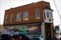
 view gallery view galleryNE27.5 km |  Creede, CO Creede, CO
in City and Town Halls The picturesque town of Creede was one of Colorado's last silver boom towns. posted by: IJAdventures location: Colorado date approved: 11/15/2012 last visited: never |
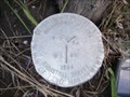
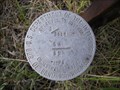
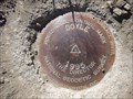 view gallery view gallery SE28 km SE28 km
|  Doyle Doyle
in U.S. Benchmarks Horizontal Control Disk at lookout point west of Wolf Creek Pass. posted by: urtica location: Colorado date approved: 04/10/2011 last visited: never |
 view gallery view galleryNE28.3 km |  Wagon Wheel Gap - Mineral County, CO Wagon Wheel Gap - Mineral County, CO
in American Guide Series Wagon Wheel Gap is easily found on Colorado State Highway 149. posted by: cldisme location: Colorado date approved: 07/07/2010 last visited: 11/01/2012 |
 view gallery view galleryNE28.3 km |  Wagon Wheel Gap - Mineral County, Colorado Wagon Wheel Gap - Mineral County, Colorado
in Named Mountain Gaps Wagon Wheel Gap is easily found on Colorado State Highway 149. posted by: cldisme location: Colorado date approved: 06/25/2010 last visited: 07/07/2020 |
 view gallery view gallerySE29.3 km | Treasure Falls in Waterfalls Discover the Legend of Treasure Mountain and maybe a cache of gold in Southern Colorado off US HWY 160 between Pagosa Springs & South Fork. posted by: logan1 location: Colorado date approved: 01/25/2006 last visited: 10/28/2019 |
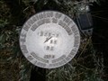
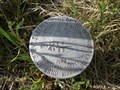
 view gallery view gallery S29.5 km S29.5 km
| Endaba Lodge N Section marker in U.S. Benchmarks This cadastral pin marks the northern border of Endaba Lodge property that crosses the section line. posted by: Fish Seal location: Colorado date approved: 07/02/2012 last visited: never |
 view gallery view galleryS29.6 km | Endaba Lodge NW property corner in U.S. Benchmarks This cadastral pin marks the NW corner of the Endaba Lodge property. posted by: Fish Seal location: Colorado date approved: 07/02/2012 last visited: never |
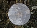 view gallery view galleryS29.8 km | Endaba Lodge 4 Section Pin in U.S. Benchmarks Cadastral pin set in 1989 indicating it's location T36N R2.5W Section 1 and 12, and T36N R2W Section 6 and 7. posted by: Fish Seal location: Colorado date approved: 06/26/2012 last visited: never |
 view gallery view galleryS29.8 km | Endaba Lodge ENE Property Corner in U.S. Benchmarks This cadastral marks the ENE property corner of Endaba Lodge. posted by: Fish Seal location: Colorado date approved: 07/01/2012 last visited: never |
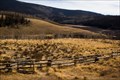
 view gallery view galleryS29.8 km | Endaba Lodge Corral Corner in U.S. Benchmarks A cadastral pin located at the corral corner east of the lodge and pond. posted by: Fish Seal location: Colorado date approved: 06/28/2012 last visited: never |
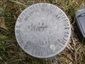
 view gallery view galleryS29.8 km | Endaba Lodge inside NE property corner in U.S. Benchmarks Cadastral pin set in 1989 indicating it's location W-W 1/64 of T36N R2W Section 6 and Section 7. posted by: Fish Seal location: Colorado date approved: 06/28/2012 last visited: never |
|