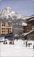
 view gallery view gallery E11.3 km E11.3 km
|   Durango Mtn Resort Durango Mtn Resort
in Ski Lodges Durango ski area posted by:  kingbee kingbee location: Colorado date approved: 09/29/2011 last visited: 09/14/2019 |
 E11.6 km |  Durango Mtn resort Colorado Durango Mtn resort Colorado
in Web Cameras Durango co posted by: kingbee location: Colorado date approved: 06/15/2015 last visited: never |
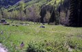 view gallery view gallery NW12.9 km NW12.9 km
|  Rico Cemetery - Rico, CO Rico Cemetery - Rico, CO
in Worldwide Cemeteries The Rico Cemetery lies between CO Hwy 145 and the Dolores River just south of Rico, CO. posted by: hummerstation location: Colorado date approved: 07/06/2015 last visited: never |
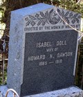 view gallery view galleryNW12.9 km |  Isabel Doll Dawson - Rico Cemetery - Rico, CO Isabel Doll Dawson - Rico Cemetery - Rico, CO
in Woodmen of the World Grave Markers/Monuments The Isabel Doll Women of Woodcraft marker is located in Rico Cemetery. posted by: hummerstation location: Colorado date approved: 07/04/2015 last visited: never |
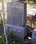 view gallery view galleryNW12.9 km | Emily B. Meredith - Rico Cemetery - Rico, CO in Woodmen of the World Grave Markers/Monuments The Emily B. Meredith Neighbors of Woodcraft marker is located in Rico Cemetery. posted by: hummerstation location: Colorado date approved: 07/06/2015 last visited: never |
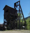 view gallery view galleryNW14.2 km |  The Atlantic Cable Mine - Rico, CO The Atlantic Cable Mine - Rico, CO
in Mines The Atlantic Cable Mine headframe and part of the hoist house are located on CO Hwy 145 on the north side of Rico. posted by: hummerstation location: Colorado date approved: 07/07/2015 last visited: never |
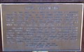 view gallery view galleryNW14.2 km |  Rico, Colorado - Rico, CO Rico, Colorado - Rico, CO
in Colorado Historical Markers The Rico, Colorado historical marker is a bronze plaque mounted on a mine car. posted by: hummerstation location: Colorado date approved: 07/05/2015 last visited: never |
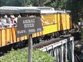 view gallery view gallery SE16.1 km SE16.1 km
|  Animas River - 7200 feet Animas River - 7200 feet
in Elevation Signs This Elevation Sign is on the Durango & Silverton Narrow Guage Railroad where it crosses the Animas River. posted by: PeterNoG location: Colorado date approved: 12/12/2011 last visited: 02/13/2014 |
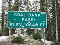 view gallery view gallery NE18.3 km NE18.3 km
| Coal Bank Pass - 10,640' in Elevation Signs Highway 550 between Silverton and Durango, Colorado. posted by: WR7X location: Colorado date approved: 04/28/2012 last visited: 07/19/2015 |
 view gallery view galleryNE18.5 km | Coal Bank Pass ~ Elevation 10,660 Feet in Elevation Signs This Elevation Sign is at the summit of Coal Bank Pass on US Highway 550 between Silverton and Durango, Colorado. posted by: brwhiz location: Colorado date approved: 04/27/2013 last visited: never |
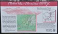
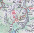 view gallery view galleryNE18.5 km |  Coal Bank Pass Summit Coal Bank Pass Summit
in 'You Are Here' Maps You Are Here at the summit of Coal Bank Pass on the San Juan Skyway in southwestern Colorado. posted by: brwhiz location: Colorado date approved: 09/12/2013 last visited: never |
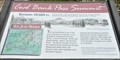
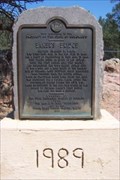 view gallery view gallerySE19.2 km | Baker's Bridge, Durango, CO in Colorado Historical Markers Baker's Bridge was rebuilt and the marker was installed for Captain Charles Baker in 1989 posted by:  new1* new1* location: Colorado date approved: 05/05/2008 last visited: 02/25/2009 |
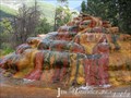 view gallery view gallerySE19.5 km |  Pinkerton Hot Springs - Durango, CO Pinkerton Hot Springs - Durango, CO
in Hot Springs The soda water from Pinkerton Hot Springs promised to cure all diseases. The water was bottled and graced many a Durango table in 1892. posted by: ArmyFamily4 location: Colorado date approved: 04/13/2011 last visited: 09/29/2021 |
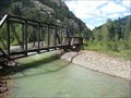
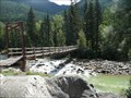 view gallery view galleryE22 km |  D&SNGRR / Needleton Footbridge - San Juan Nat'l Forest, Colorado D&SNGRR / Needleton Footbridge - San Juan Nat'l Forest, Colorado
in Hiking Path Footbridges This wooden footbridge crosses the Anamas River at the Needleton Flagstop "Station" of the Durango & Silverton Narrow Guage Railroad. posted by: PeterNoG location: Colorado date approved: 12/12/2011 last visited: 08/27/2008 |
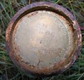 view gallery view gallery SW25.1 km SW25.1 km
|  La Plata PN 09294 ID 36 La Plata PN 09294 ID 36
in U.S. Benchmarks State of Colorado Division of Minerals and Geology - Reclamation Project 294, Feature ID 36 posted by: StumpAuthor location: Colorado date approved: 10/25/2009 last visited: never |
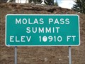 view gallery view galleryNE26.6 km | Molas Pass - 10,910' in Elevation Signs Highway 550 between Silverton and Durango, Colorado. posted by: WR7X location: Colorado date approved: 04/28/2012 last visited: 09/12/2019 |
 view gallery view galleryNE26.6 km | Molas Pass ~ Elevation 10,899 Feet in Elevation Signs This Elevation Sign is at the summit of Molas Pass on US Highway 550 between Silverton and Durango, Colorado. posted by: brwhiz location: Colorado date approved: 04/27/2013 last visited: 09/12/2019 |
 view gallery view galleryNE28.6 km |  Durango-Silverton RR Bridge - Animas Valley CO Durango-Silverton RR Bridge - Animas Valley CO
in Railroad Bridges This Railroad Bridge is a half hour from the Silverton Station on the Durango & Silverton Narrow Gauge Railroad. posted by: PeterNoG location: Colorado date approved: 01/03/2014 last visited: 08/27/2008 |
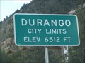 view gallery view gallery S30.4 km S30.4 km
| Durango, Colorado - 6512' in Elevation Signs The sign is located at the north city limits of Durango along Highway 550. posted by: WR7X location: Colorado date approved: 04/28/2012 last visited: 07/14/2015 |
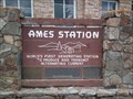 view gallery view gallery N30.7 km N30.7 km
|  Ames Hydroelectric Station Ames Hydroelectric Station
in First of its Kind The Ames Station is the world's first generating station to produce and transmit alternating current. posted by: krazykatzen location: Colorado date approved: 06/27/2010 last visited: never |
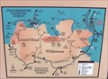 view gallery view galleryN32.3 km | You Are Here - A Wilderness Legacy - Ophir, CO in 'You Are Here' Maps The "A Wilderness Legacy" panel is located on the west side of Colorado Hwy 145 between Lizard Head Pass and Ophir. posted by: hummerstation location: Colorado date approved: 07/05/2015 last visited: never |
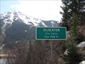 view gallery view galleryNE33 km | Silverton, Colorado - 9318' in Elevation Signs The sign is located on northbound Highway 550. posted by: WR7X location: Colorado date approved: 04/29/2012 last visited: 06/04/2015 |
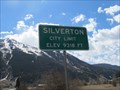 view gallery view galleryNE33.2 km | Silverton, Colorado - 9318' in Elevation Signs This sign is located on southbound Highway 550. posted by: WR7X location: Colorado date approved: 04/29/2012 last visited: 07/14/2015 |
 view gallery view galleryNE33.3 km |  Triangle Convenience Store (Conoco Gas Station) Penny Smasher Triangle Convenience Store (Conoco Gas Station) Penny Smasher
in Penny Smashers This three-design Penny Smasher is in the Triangle Convenience Store (Conoco Gas Station) at 315 Greene Street in Silverton, Colorado. posted by: brwhiz location: Colorado date approved: 10/22/2011 last visited: never |
 view gallery view galleryS33.3 km |  Durango and Silverton Scenic Narrow Gauge Railroad -Durango CO Durango and Silverton Scenic Narrow Gauge Railroad -Durango CO
in Scenic Railroads The Durango & Silverton Narrow Gauge Railroad, often abbreviated as the D&SNG, is a 3 ft (914 mm) narrow-gauge heritage railroad that operates on 45.2 miles (72.7 km) of track between Durango and Silverton, in the U.S. state of Colorado. posted by: Don.Morfe location: Colorado date approved: 12/24/2020 last visited: 07/08/2023 |
|