 view gallery view gallery NE3.5 km NE3.5 km
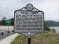
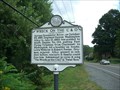
|   Pack's Ferry Pack's Ferry
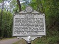
in West Virginia Historical Markers A short Civil War battle occurred here. posted by:  dukemartin dukemartin location: West Virginia date approved: 08/14/2017 last visited: 04/22/2024 |
 view gallery view gallery N3.9 km N3.9 km
| Giles, Fayette & Kanawha Turnpike in West Virginia Historical Markers A quick,description of the route of the turnpike. posted by: dukemartin location: West Virginia date approved: 09/18/2017 last visited: 09/18/2017 |
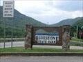
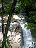
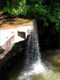 view gallery view galleryN4 km |  Almost Hidden Waterfall -- Bluestone State Park Almost Hidden Waterfall -- Bluestone State Park
in Waterfalls A small, nearly hidden waterfall in Bluestone State Park in West Virginia. posted by: Deweyz location: West Virginia date approved: 06/23/2006 last visited: 04/03/2019 |
 view gallery view galleryNE4 km |  Bluestone National Scenic River - Hinton WV Bluestone National Scenic River - Hinton WV
in National Wild and Scenic Rivers The lower 10 miles of the designated segment flow through an 800-foot deep gorge and offer warmwater fishing, whitewater boating when water level permits, and hiking along the river on a trail between Bluestone and Pipestem State Parks. posted by:  Don.Morfe Don.Morfe location: West Virginia date approved: 12/28/2020 last visited: 04/22/2024 |
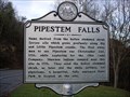 view gallery view gallery SW4.2 km SW4.2 km
| Pipestem Falls in West Virginia Historical Markers A sign telling about how a shrub was used to make pipe stems. posted by: Paintedwarrior location: West Virginia date approved: 11/28/2011 last visited: 12/03/2011 |
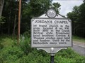 view gallery view gallerySW4.5 km | Jordan's Chapel in West Virginia Historical Markers Short history of church. posted by: dukemartin location: West Virginia date approved: 08/14/2017 last visited: 08/14/2017 |
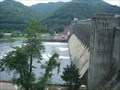 view gallery view galleryNE7.9 km |  Bluestone Dam - Hinton WV Bluestone Dam - Hinton WV
in Water Dams Spanning the New River at Hinton the dam forms Bluestone Lake, the third largest lake in West Virginia. posted by: fatcat161 location: West Virginia date approved: 08/26/2009 last visited: 04/22/2024 |
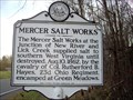 view gallery view gallery S8 km S8 km
| Mercer Salt Works in West Virginia Historical Markers A sign telling us where southern West Virginia got its salt from until 1862. posted by: Paintedwarrior location: West Virginia date approved: 11/28/2011 last visited: 12/03/2011 |
 view gallery view galleryNE8 km |  Bluestone Dam - Hinton, WV Bluestone Dam - Hinton, WV
in Fishing Holes Fishing spot is near the end of Miller Ave in Hinton, WV. posted by: fatcat161 location: West Virginia date approved: 11/17/2009 last visited: 04/22/2024 |
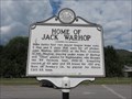 view gallery view galleryNE8.5 km | Home of Jack Warhop in West Virginia Historical Markers Babe Ruth's first two major league home runs were hit off of this pitcher. posted by: dukemartin location: West Virginia date approved: 09/18/2017 last visited: 09/18/2017 |
 view gallery view galleryS8.5 km | Neely "Plantation" in West Virginia Historical Markers A short history of the Neely family and Pipestem State Park. posted by: dukemartin location: West Virginia date approved: 08/14/2017 last visited: 08/14/2017 |
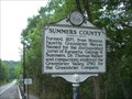
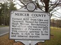 view gallery view galleryS9 km | Mercer / Summers County in West Virginia Historical Markers A sign telling us from where Mercer and Summers counties were formed. posted by: Paintedwarrior location: West Virginia date approved: 11/28/2011 last visited: 12/03/2011 |
 view gallery view galleryNE9.2 km | Fort Culbertson in West Virginia Historical Markers Greenbrier Drive (WV 3) East and Cedar Avenue, 2.0 miles west of the WV 12 split, 2 blocks east of WV 107 posted by: fatcat161 location: West Virginia date approved: 09/02/2009 last visited: 09/17/2017 |
 view gallery view galleryNE9.3 km | The Wreck on the C&O in West Virginia Historical Markers WV 3, 0.8 miles from junction with WV 3/WV 20, Hinton, WV. This is near the intersection of Hwy 3 and Pine St. posted by: fatcat161 location: West Virginia date approved: 09/02/2009 last visited: 09/17/2017 |
 view gallery view galleryNE9.3 km |  "Fatal Run" - Cliff Carlisle "Fatal Run" - Cliff Carlisle
in Immortalized in Lyrics WV 3, 0.8 miles from junction with WV 3/WV 20, Hinton, WV. This is near the intersection of Hwy 3 and Pine St.
posted by: fatcat161 location: West Virginia date approved: 08/26/2009 last visited: 09/17/2017 |
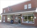
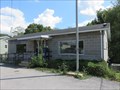 view gallery view gallerySW9.8 km |  Lerona WV 25971 Post Office Lerona WV 25971 Post Office
in U.S. Post Offices Lerona WV Post Office posted by: dukemartin location: West Virginia date approved: 09/25/2017 last visited: never |
 view gallery view galleryN10.9 km | Hinton in West Virginia Historical Markers A short history of the Hinton WV area. posted by: dukemartin location: West Virginia date approved: 09/18/2017 last visited: 09/18/2017 |
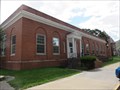 view gallery view galleryN10.9 km | Hinton WV 25951 Post Office in U.S. Post Offices Hinton WV, Post Office posted by: dukemartin location: West Virginia date approved: 09/25/2017 last visited: 04/22/2024 |
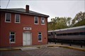 view gallery view galleryN11.3 km |  Chesapeake & Ohio RR station - Hinton, West Virginia Chesapeake & Ohio RR station - Hinton, West Virginia
in Train Stations/Depots The Hinton Station is located at 100 2nd Ave at Maple Ave. It was built in 1913 for the C&O Railroad. It currently serves Amtrak's Cardinal. posted by: buffalohiker location: West Virginia date approved: 11/06/2019 last visited: 04/22/2024 |
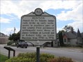
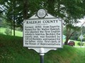 view gallery view gallery NW12.4 km NW12.4 km
| Raleigh County/Summers County in West Virginia Historical Markers Located on Hwy 3 near Walnut Ln in Jumping Branch, WV posted by: fatcat161 location: West Virginia date approved: 09/02/2009 last visited: 05/26/2017 |
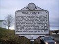 view gallery view gallery E12.7 km E12.7 km
| Mike Foster in West Virginia Historical Markers A sign telling us of the battles Mike Foster fought in. posted by: Paintedwarrior location: West Virginia date approved: 01/13/2016 last visited: 01/13/2016 |
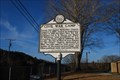 view gallery view galleryE13 km | Civil War Camp in West Virginia Historical Markers Along WV 12 in front of Forest Hill United Methodist Church posted by: bitmapped location: West Virginia date approved: 02/12/2010 last visited: 01/13/2016 |
 view gallery view galleryE14 km | Monroe County/Summers County in West Virginia Historical Markers Located just north of Red Sulphur Marie (CR21/4) on Hwy 12 at the county line. posted by: fatcat161 location: West Virginia date approved: 09/02/2009 last visited: 01/13/2016 |
 view gallery view gallerySW14.2 km |  Brush Creek Swimmin' Spot Brush Creek Swimmin' Spot
in Swimming Holes A nice swimming spot at the base of Brush Creek Falls. posted by: Deweyz location: West Virginia date approved: 09/14/2007 last visited: 06/25/2011 |
 view gallery view gallery W15.1 km W15.1 km
| Flat Top, WV 25841 in U.S. Post Offices One of many small post offices along US 19. posted by: ChapterhouseInc location: West Virginia date approved: 07/13/2010 last visited: 05/26/2017 |
|