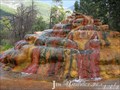
 view gallery view gallery N22.4 km N22.4 km
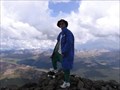
|   Rio Grande Pyramid Rio Grande Pyramid
in Mountain Summits A class II jaunt up a mountain in the Weminuche Wilderness. There are excellent views to the west of Windom, Sunlight, The Guardian and other imposing peaks. Interesting perspective of the Window formation to the south, and nice vistas to the north and east. posted by:  krazykatzen krazykatzen location: Colorado date approved: 10/02/2006 last visited: never |
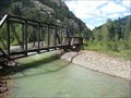
 view gallery view gallery NW24.1 km NW24.1 km
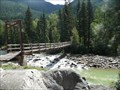
|  D&SNGRR / Needleton Footbridge - San Juan Nat'l Forest, Colorado D&SNGRR / Needleton Footbridge - San Juan Nat'l Forest, Colorado
in Hiking Path Footbridges This wooden footbridge crosses the Anamas River at the Needleton Flagstop "Station" of the Durango & Silverton Narrow Guage Railroad. posted by:  PeterNoG PeterNoG location: Colorado date approved: 12/12/2011 last visited: 08/27/2008 |
 view gallery view gallery W26.7 km W26.7 km
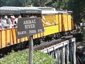
|  Animas River - 7200 feet Animas River - 7200 feet
in Elevation Signs This Elevation Sign is on the Durango & Silverton Narrow Guage Railroad where it crosses the Animas River. posted by: PeterNoG location: Colorado date approved: 12/12/2011 last visited: 02/13/2014 |
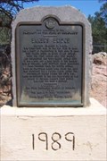 view gallery view galleryW28 km |  Baker's Bridge, Durango, CO Baker's Bridge, Durango, CO
in Colorado Historical Markers Baker's Bridge was rebuilt and the marker was installed for Captain Charles Baker in 1989 posted by: new1* location: Colorado date approved: 05/05/2008 last visited: 02/25/2009 |
 view gallery view galleryW28.6 km |  Pinkerton Hot Springs - Durango, CO Pinkerton Hot Springs - Durango, CO
in Hot Springs The soda water from Pinkerton Hot Springs promised to cure all diseases. The water was bottled and graced many a Durango table in 1892. posted by: ArmyFamily4 location: Colorado date approved: 04/13/2011 last visited: 09/29/2021 |
 view gallery view galleryNW29 km |  Durango-Silverton RR Bridge - Animas Valley CO Durango-Silverton RR Bridge - Animas Valley CO
in Railroad Bridges This Railroad Bridge is a half hour from the Silverton Station on the Durango & Silverton Narrow Gauge Railroad. posted by: PeterNoG location: Colorado date approved: 01/03/2014 last visited: 08/27/2008 |
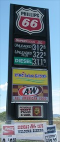 view gallery view gallery S30.4 km S30.4 km
|  A&W - Bayfield, Colorado A&W - Bayfield, Colorado
in A + W Restaurants This A&W is combined with a gas station. posted by: SageInThyme82 location: Colorado date approved: 09/30/2015 last visited: 10/07/2009 |
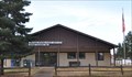 view gallery view galleryS31.2 km |  Bayfield, Colorado 81122 Bayfield, Colorado 81122
in U.S. Post Offices This Post Office is located at 145 Park Street in Bayfield, Colorado. posted by: brwhiz location: Colorado date approved: 10/31/2011 last visited: 10/01/2019 |
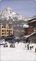 view gallery view galleryNW32.8 km |  Durango Mtn Resort Durango Mtn Resort
in Ski Lodges Durango ski area posted by: kingbee location: Colorado date approved: 09/29/2011 last visited: 09/14/2019 |
 NW32.8 km |  Durango Mtn resort Colorado Durango Mtn resort Colorado
in Web Cameras Durango co posted by: kingbee location: Colorado date approved: 06/15/2015 last visited: never |
 view gallery view galleryNW33 km | Molas Pass ~ Elevation 10,899 Feet in Elevation Signs This Elevation Sign is at the summit of Molas Pass on US Highway 550 between Silverton and Durango, Colorado. posted by: brwhiz location: Colorado date approved: 04/27/2013 last visited: 09/12/2019 |
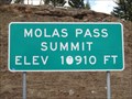 view gallery view galleryNW33.2 km | Molas Pass - 10,910' in Elevation Signs Highway 550 between Silverton and Durango, Colorado. posted by: WR7X location: Colorado date approved: 04/28/2012 last visited: 09/12/2019 |
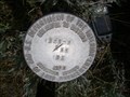
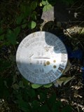
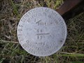
 view gallery view gallery SE34.1 km SE34.1 km
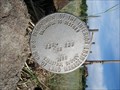
|  Perry Drive & USFS 181 Perry Drive & USFS 181
in U.S. Benchmarks A cadastral pin located at the intersection of Perry Drive and USFS 181 (still Perry Drive, but marked with USFS 181). This is the marker for the T36N R2.5W Section 11 SE 1/16. posted by: Fish Seal location: Colorado date approved: 07/01/2012 last visited: never |
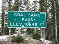 view gallery view galleryNW34.4 km | Coal Bank Pass - 10,640' in Elevation Signs Highway 550 between Silverton and Durango, Colorado. posted by: WR7X location: Colorado date approved: 04/28/2012 last visited: 07/19/2015 |
 view gallery view galleryNW34.4 km | Coal Bank Pass ~ Elevation 10,660 Feet in Elevation Signs This Elevation Sign is at the summit of Coal Bank Pass on US Highway 550 between Silverton and Durango, Colorado. posted by: brwhiz location: Colorado date approved: 04/27/2013 last visited: never |
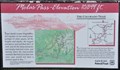
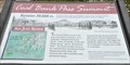
 view gallery view galleryNW34.4 km |  Coal Bank Pass Summit Coal Bank Pass Summit
in 'You Are Here' Maps You Are Here at the summit of Coal Bank Pass on the San Juan Skyway in southwestern Colorado. posted by: brwhiz location: Colorado date approved: 09/12/2013 last visited: never |
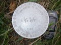
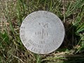
 view gallery view gallery E34.6 km E34.6 km
| Endaba Lodge NW property corner in U.S. Benchmarks This cadastral pin marks the NW corner of the Endaba Lodge property. posted by: Fish Seal location: Colorado date approved: 07/02/2012 last visited: never |
 view gallery view galleryE34.8 km | Endaba Lodge WSW property corner in U.S. Benchmarks This cadastral marker marks the WSW corner of the Endaba Lodge property. posted by: Fish Seal location: Colorado date approved: 07/02/2012 last visited: never |
 view gallery view galleryE35.1 km | Endaba Lodge inside SW corner in U.S. Benchmarks This cadastral pin is located at the inside SW corner of the Endaba Lodge. posted by: Fish Seal location: Colorado date approved: 07/02/2012 last visited: never |
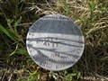
 view gallery view galleryE35.4 km | Endaba Lodge N Section marker in U.S. Benchmarks This cadastral pin marks the northern border of Endaba Lodge property that crosses the section line. posted by: Fish Seal location: Colorado date approved: 07/02/2012 last visited: never |
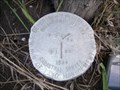
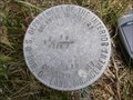
 view gallery view galleryE35.6 km | Endaba Lodge 4 Section Pin in U.S. Benchmarks Cadastral pin set in 1989 indicating it's location T36N R2.5W Section 1 and 12, and T36N R2W Section 6 and 7. posted by: Fish Seal location: Colorado date approved: 06/26/2012 last visited: never |
 view gallery view galleryE35.6 km | Endaba Lodge Corral Corner in U.S. Benchmarks A cadastral pin located at the corral corner east of the lodge and pond. posted by: Fish Seal location: Colorado date approved: 06/28/2012 last visited: never |
 view gallery view galleryE35.6 km | Endaba Lodge SE of pond in U.S. Benchmarks Cadastral pin set in 1989 indicating it's location N 1/16 of T36N R2.5W Section 12 and T36N R2W Section 7. posted by: Fish Seal location: Colorado date approved: 06/25/2012 last visited: never |
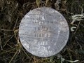
 view gallery view galleryE35.7 km | Endaba Lodge inside NE property corner in U.S. Benchmarks Cadastral pin set in 1989 indicating it's location W-W 1/64 of T36N R2W Section 6 and Section 7. posted by: Fish Seal location: Colorado date approved: 06/28/2012 last visited: never |
 view gallery view galleryE35.9 km | Endaba Lodge ENE Property Corner in U.S. Benchmarks This cadastral marks the ENE property corner of Endaba Lodge. posted by: Fish Seal location: Colorado date approved: 07/01/2012 last visited: never |
|