 view gallery view gallery E7.1 km E7.1 km
|   New Harmony New Harmony
in Utah Historical Markers New Harmony began as Harmony, moved to a new site called Fort Harmony, then moved a second time to its present location. posted by:  brwhiz brwhiz location: Utah date approved: 01/22/2012 last visited: 09/09/2013 |
 view gallery view galleryE7.1 km |  First School House in New Harmony First School House in New Harmony
in First of its Kind The first school house in New harmony was a frame structure erected in 1863. posted by: brwhiz location: Utah date approved: 01/21/2012 last visited: 09/18/2013 |
 view gallery view galleryE7.1 km | First LDS Bishop of New Harmony in First of its Kind The first LDS Bishop of New Harmony was Wilson D. Pace. posted by: brwhiz location: Utah date approved: 01/21/2012 last visited: never |
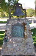 view gallery view galleryE7.1 km |  New Harmony School Bell New Harmony School Bell
in Bells The bell on the New Harmony school house called members of the community to all public gatherings for nearly a century. That bell is now mounted atop this monument. posted by: brwhiz location: Utah date approved: 01/21/2012 last visited: 09/09/2013 |
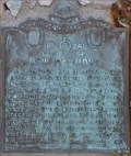
 view gallery view galleryE7.1 km |  New Harmony ~ 261 New Harmony ~ 261
in D.U.P. Historic Markers New Harmony began as Harmony, moved to a new site called Fort Harmony, then moved a second time to its present location. posted by: brwhiz location: Utah date approved: 01/21/2012 last visited: 09/09/2013 |
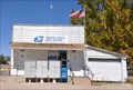 view gallery view galleryE7.1 km |  New Harmony, Utah 84757 New Harmony, Utah 84757
in U.S. Post Offices This Post Office is located at 3 E 100 North in New Harmony, Utah. posted by: brwhiz location: Utah date approved: 11/09/2011 last visited: 05/25/2014 |
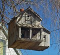 view gallery view galleryE7.4 km |  New Harmony, Old Hotel New Harmony, Old Hotel
in Unique Bird Houses A nice bird house near grandpa's home in New Harmony. posted by: Tradsud location: Utah date approved: 02/05/2006 last visited: 06/25/2012 |
 view gallery view galleryE7.7 km | Military Training Camp Site in Utah Historical Markers This historical marker, erected by the Daughters of Utah Pioneers, is mounted on a stone monument just northwest of the curve where 400 East becomes Utah Highway 144 just north of the cemetery. posted by: brwhiz location: Utah date approved: 12/19/2013 last visited: never |
 view gallery view galleryE7.7 km | Military Training Camp Site ~ 67 in D.U.P. Historic Markers This historical marker, erected by the Daughters of Utah Pioneers, is mounted on a stone monument just northwest of the curve where 400 East becomes Utah Highway 144 just north of the cemetery. posted by: brwhiz location: Utah date approved: 01/21/2014 last visited: never |
 view gallery view gallery N9.8 km N9.8 km
| Page Ranch House in Utah Historical Markers The Page Ranch House is a unique building design, and even more unique in its remote location. posted by: brwhiz location: Utah date approved: 03/13/2012 last visited: 09/10/2013 |
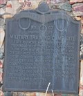
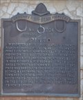
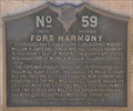 view gallery view galleryE12.7 km | Fort Harmony in Utah Historical Markers The historic Fort Harmony site is just west of Interstate 15 at the New Harmony exit. posted by: brwhiz location: Utah date approved: 04/05/2012 last visited: 09/01/2013 |
 view gallery view gallery NW12.9 km NW12.9 km
| Pinto in Utah Historical Markers The town of Pinto was named after the pinto-like coloring of the surrounding rock formations. posted by: brwhiz location: Utah date approved: 03/14/2012 last visited: never |
 view gallery view galleryNW12.9 km | First LDS Bishop of Pinto, Utah in First of its Kind The first LDS Bishop of Pinto was Richard S. Robinson. posted by: brwhiz location: Utah date approved: 03/13/2012 last visited: never |
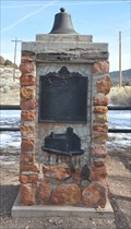 view gallery view galleryNW12.9 km | Pinto Marker Bell - Pinto, Iron County, Utah in Bells The bell on top of the Pinto historical marker monument is probably from the original LDS Church in Pinto, Utah. posted by: brwhiz location: Utah date approved: 03/13/2012 last visited: never |
 view gallery view galleryNW12.9 km | Pinto ~ 204 in D.U.P. Historic Markers The town of Pinto was named after the pinto-like coloring of the surrounding rock formations. posted by: brwhiz location: Utah date approved: 03/29/2012 last visited: never |
 view gallery view galleryNW13.7 km |  Rubber Rabbitbrush Rubber Rabbitbrush
in Flora and Fauna Information Signs This Flora and Fauna Information Sign is located on the interpretive trail through the Old Irontown site west of Cedar City, Utah. posted by: brwhiz location: Utah date approved: 11/26/2012 last visited: never |
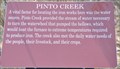 view gallery view galleryNW13.7 km | Pinto Creek in Utah Historical Markers This Historical Marker is mounted on a steel post overlooking the Pinto Creek channel on the edge of Old Iron Town State Park Historic Site on Iron Town Road southwest of Utah Highway 56, west of Cedar City, Utah. posted by: brwhiz location: Utah date approved: 03/26/2013 last visited: never |
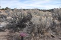
 view gallery view galleryNW13.7 km | Big Sagebrush in Flora and Fauna Information Signs This Flora and Fauna Information Sign is located on the interpretive trail through the Old Irontown site west of Cedar City, Utah. posted by: brwhiz location: Utah date approved: 11/26/2012 last visited: never |
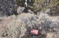
![Image for House [Ruins]](https://img.geocaching.com/waymarking/small/ee7dfb3d-8bd9-440c-966a-876560ee4708.JPG) view gallery view galleryN13.8 km | House [Ruins] in Utah Historical Markers This Historical Marker is mounted on a steel post in front of the ruins of a house inside Old Iron Town State Park Historic Site on Iron Town Road southwest of Utah Highway 56, west of Cedar City, Utah. posted by: brwhiz location: Utah date approved: 03/26/2013 last visited: 09/06/2013 |
 view gallery view galleryNW13.8 km | Squawbush in Flora and Fauna Information Signs This Flora and Fauna Information Sign is located on the interpretive trail through the Old Irontown site west of Cedar City, Utah. posted by: brwhiz location: Utah date approved: 11/26/2012 last visited: 01/02/2023 |
 view gallery view galleryNW13.8 km | Basin Wildrye in Flora and Fauna Information Signs This Flora and Fauna Information Sign is located on the interpretive trail through the Old Irontown site west of Cedar City, Utah. posted by: brwhiz location: Utah date approved: 11/26/2012 last visited: 01/02/2023 |
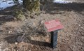
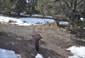
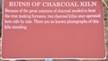 view gallery view galleryNW13.8 km | Ruins of Charcoal Kiln in Utah Historical Markers This Historical Marker is mounted on a steel post in front of the ruins of one charcoal kiln inside Old Iron Town State Park Historic Site on Iron Town Road southwest of Utah Highway 56, west of Cedar City, Utah. posted by: brwhiz location: Utah date approved: 03/26/2013 last visited: 08/22/2014 |
 view gallery view galleryNW13.8 km | Pinyon Pine in Flora and Fauna Information Signs This Flora and Fauna Information Sign is located on the interpretive trail through the Old Irontown site west of Cedar City, Utah. posted by: brwhiz location: Utah date approved: 11/26/2012 last visited: 09/08/2013 |
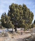 view gallery view galleryNW13.8 km | Utah Juniper in Flora and Fauna Information Signs This Flora and Fauna Information Sign is located on the interpretive trail through the Old Irontown site west of Cedar City, Utah. posted by: brwhiz location: Utah date approved: 11/26/2012 last visited: 01/02/2023 |
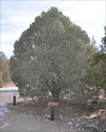
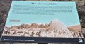 view gallery view galleryNW13.8 km | The Charcoal Kiln in Utah Historical Markers This Historical Marker is mounted on a steel post in front of the remaining charcoal kiln inside Old Iron Town State Park Historic Site on Iron Town Road southwest of Utah Highway 56, west of Cedar City, Utah. posted by: brwhiz location: Utah date approved: 03/26/2013 last visited: 01/02/2023 |
|