 view gallery view gallery E15.1 km E15.1 km
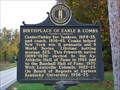
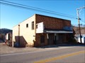
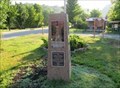
|   Birthplace of Earle B. Combs - Pebworth, KY Birthplace of Earle B. Combs - Pebworth, KY
in Kentucky Historical Markers Birthplace of Earle B. Combs Historical Marker, Pebworth, KY posted by:  hummerstation hummerstation location: Kentucky date approved: 11/02/2011 last visited: never |
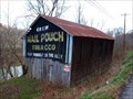
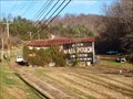 view gallery view galleryE15.8 km |  Mail Pouch Barn - MPB 17-95-02 Mail Pouch Barn - MPB 17-95-02
in Barns MPB 17-95-02 posted by:  Wallyum Wallyum location: Kentucky date approved: 03/30/2021 last visited: never |
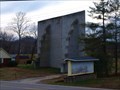 view gallery view galleryE18.7 km |  Moonlite Drive-In Moonlite Drive-In
in Closed Drive-In Theatres Fairly tiny back yard drive-in in Booneville, KY. posted by: Wallyum location: Kentucky date approved: 04/02/2021 last visited: 11/26/2010 |
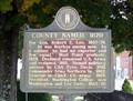
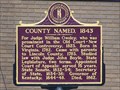 view gallery view galleryE19.5 km | County Named, 1843 - Booneville, KY in Kentucky Historical Markers County Named, 1843 Historical Marker, Booneville, KY posted by: hummerstation location: Kentucky date approved: 11/01/2011 last visited: never |
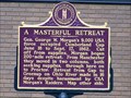 view gallery view galleryE19.5 km | A Masterful Retreat - Booneville, KY in Kentucky Historical Markers A Masterful Retreat Historical Marker, Booneville, KY posted by: hummerstation location: Kentucky date approved: 11/01/2011 last visited: never |
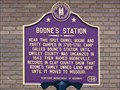 view gallery view galleryE19.5 km | Boone’s Station - Booneville, KY in Kentucky Historical Markers Boone’s Station Historial Marker, Booneville, KY posted by: hummerstation location: Kentucky date approved: 11/01/2011 last visited: never |
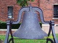
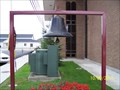 view gallery view galleryE19.5 km |  Owsley County Courthouse Bell - Booneville, KY Owsley County Courthouse Bell - Booneville, KY
in Bells Owsley County Courthouse Bell, Booneville, KY posted by: hummerstation location: Kentucky date approved: 11/06/2011 last visited: never |
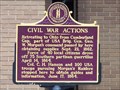 view gallery view galleryE19.5 km | Civil War Actions - Booneville, KY in Kentucky Historical Markers Civil War Actions Historical Marker, Booneville, KY posted by: hummerstation location: Kentucky date approved: 11/01/2011 last visited: never |
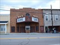
 view gallery view galleryE19.5 km |  Booneville Theatre Booneville Theatre
in Vintage Movie Theaters Old theater that's seen better days. posted by: Wallyum location: Kentucky date approved: 03/15/2011 last visited: 11/26/2010 |
 view gallery view gallery NE20 km NE20 km
| County Named, 1870 - Beattyville, KY in Kentucky Historical Markers County Named, 1870 Historical Marker, Beattyville, KY posted by: hummerstation location: Kentucky date approved: 11/01/2011 last visited: never |
 view gallery view galleryNE20 km | Lee County Courthouse Bell - Beattyville, KY in Bells Lee County Courthouse Bell, Beattyville, KY posted by: hummerstation location: Kentucky date approved: 11/06/2011 last visited: 12/15/2011 |
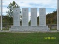 view gallery view galleryNE20.1 km |  Lee County War Memorial - Beattyville, KY Lee County War Memorial - Beattyville, KY
in Non-Specific Veteran Memorials Lee County War Memorial, Beattyville, KY posted by: hummerstation location: Kentucky date approved: 11/16/2011 last visited: 11/07/2020 |
 view gallery view gallery SE20.6 km SE20.6 km
| Mail Pouch Barn - MPB 17-95-01 in Barns MPB 17-95-01, Owsley County, KY posted by: Wallyum location: Kentucky date approved: 03/30/2021 last visited: never |
 view gallery view gallery N26.4 km N26.4 km
| Mack Theater - Irvine, Kentucky in Vintage Movie Theaters The Mack was one of two theaters operating on Main Street in Irvine, Kentucky. posted by: Wallyum location: Kentucky date approved: 07/01/2010 last visited: never |
 view gallery view gallery SW29.9 km SW29.9 km
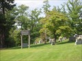
|  Red Hill Community Cemetery, Livingston, Kentucky Red Hill Community Cemetery, Livingston, Kentucky
in Worldwide Cemeteries Community cemetery in the deep forrests of Kentucky high on top of Red Hill near Livingston, Kentucky posted by: PersonsMD location: Kentucky date approved: 08/31/2009 last visited: 08/24/2009 |
 view gallery view gallerySW31.2 km |  Daniel Boone's Trail - Bernstadt. KY Daniel Boone's Trail - Bernstadt. KY
in Wagon Roads and Trails From North Carolina to Kentucky 1775. Erected by the Kentucky Daughters of the American Revolution 1915. posted by: Crazy4horses location: Kentucky date approved: 03/19/2023 last visited: never |
 view gallery view gallerySW31.2 km |  Daniel Boone's Trail - Bernstadt, KY, USA Daniel Boone's Trail - Bernstadt, KY, USA
in Daughters of the American Revolution Daniel Boone’s Trail is the famous trail constructed by Daniel Boone and his party of pioneers in 1775. The Trail ran from Cumberland Gap to Fort Boonesborough. This is a sandstone rock on a concrete slab with a brass plaque and no DAR Insignia. posted by: Crazy4horses location: Kentucky date approved: 05/27/2023 last visited: never |
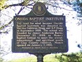 view gallery view gallerySE31.4 km | Oneida Baptist Institute - Oneida, KY in Kentucky Historical Markers Oneida Baptist Institute historical marker on the campus of Oneida Baptist Institute, Oneida, KY posted by: hummerstation location: Kentucky date approved: 10/20/2010 last visited: 10/23/2008 |
 view gallery view gallery W32.8 km W32.8 km
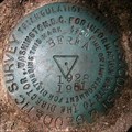
|  BEREA RESET, GZ2888, Berea, KY BEREA RESET, GZ2888, Berea, KY
in U.S. Benchmarks On the top of Bear Mtn., likely highest point in Madison County, KY. posted by: wuja location: Kentucky date approved: 07/04/2007 last visited: never |
 view gallery view galleryW33.6 km |  Madison-Rockcastle County Line Monument, Berea, KY Madison-Rockcastle County Line Monument, Berea, KY
in Dixie Highway The marker is shown as a boundary monument on the Berea, KY topo quad. Dixie Highway was routed on Scaffold Cane Road (modern KY-1617) only until 1927. posted by: wuja location: Kentucky date approved: 04/07/2008 last visited: never |
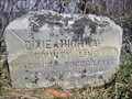 view gallery view galleryW33.6 km |  Madison-Rockcastle County Line Monument, Berea, KY Madison-Rockcastle County Line Monument, Berea, KY
in U.S. Historic Survey Stones and Monuments The marker is shown as a boundary monument on the Berea, KY topo quad. Dixie Highway was routed on Scaffold Cane Road (modern KY-1617) only until 1927. posted by: wuja location: Kentucky date approved: 04/07/2008 last visited: never |
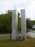 view gallery view gallerySW34.1 km |  Livingston, KY 9/11 Memorial Livingston, KY 9/11 Memorial
in 9/11 Memorial Sites Memorial located in a small rural community in southern Kentucky, along the Dixie Highway and Wilderness Road route. posted by: kbarhow location: Kentucky date approved: 09/17/2009 last visited: 10/20/2012 |
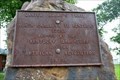
 view gallery view gallerySW34.1 km |  Livingston Trail Head Four Historic Plaques - Livingston, KY Livingston Trail Head Four Historic Plaques - Livingston, KY
in Ancient Traces and Roads Marker is on Daniel Boone Trail (U.S. 25) near Upper River Road (Kentucky Route 490), on the right when traveling north. marker is in a small park that serves as a trail head. It at the south west corner of the intersection. posted by: Crazy4horses location: Kentucky date approved: 03/20/2023 last visited: never |
 view gallery view gallerySW34.1 km | Livingston Trail Head Four Historic Plaques - Livingston, KY, USA in Daughters of the American Revolution Marker in on Daniel Boone Trail (U.S. 25) near (Kentucky Route 490) in a small park that serves as a trail head. The four plaques are on a pink granite monument. The plaques do not contain the DAR insignia. posted by: Crazy4horses location: Kentucky date approved: 05/27/2023 last visited: never |
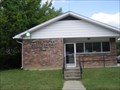 view gallery view gallerySW34.1 km |  Livingston, Kentucky 40445 Livingston, Kentucky 40445
in U.S. Post Offices A small community Post Office in the deep green woods of Kentucky. posted by: PersonsMD location: Kentucky date approved: 08/28/2009 last visited: 10/09/2013 |
|