 view gallery view gallery SE0.2 km SE0.2 km
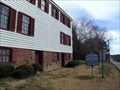
|   Halfway House Halfway House
in Virginia Historical Markers Union Army Headquarters between Richmond and Petersburg. posted by:  johnjm99 johnjm99 location: Virginia date approved: 03/04/2006 last visited: 09/18/2008 |
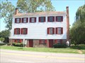 view gallery view gallerySE0.2 km |  Half Way House Half Way House
in Civil War Discovery Trail Sites Half Way House, was used by Union General Benjamin F. Butler during the "Bermuda Hundred Campaign" in the U.S. Civil War. posted by:  Taluss Taluss location: Virginia date approved: 09/21/2008 last visited: never |
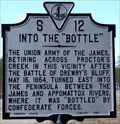 view gallery view gallerySE0.8 km | Into the Bottle in Virginia Historical Markers Virginia terrain aids Confederate forces. posted by: johnjm99 location: Virginia date approved: 03/04/2006 last visited: 07/30/2010 |
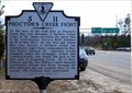 view gallery view gallerySE0.8 km | Proctor's Creek Fight in Virginia Historical Markers Civil War battle of 13-14 May 1864. posted by: johnjm99 location: Virginia date approved: 03/04/2006 last visited: 07/30/2010 |
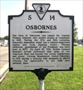 view gallery view gallerySE0.8 km | Osbornes in Virginia Historical Markers The town of Osbornes was named for Captain Thomas Osborne. posted by: Taluss location: Virginia date approved: 09/25/2008 last visited: never |
 view gallery view gallery N1.9 km N1.9 km
|  Chesterfield County, Virginia - First Choice Community Chesterfield County, Virginia - First Choice Community
in Water Towers This big, old hoss is easily, and best accessed from Route 95, North or South. It is a pain in the neck to get to as there is no nearby exit, although the posted coordinates are right on top of it. posted by: Math Teacher location: Virginia date approved: 06/01/2007 last visited: 01/18/2008 |
 view gallery view gallery S2.1 km S2.1 km
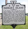
| Farrar's Island in Virginia Historical Markers Original site of the "Citie of Henrico" posted by: Taluss location: Virginia date approved: 09/26/2008 last visited: never |
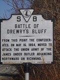 view gallery view galleryN2.1 km | Battle of Drewry's Bluff in Virginia Historical Markers After the Peninsula Campaign, Drewry's Bluff was part of the Bermuda Hundred Campaign which this marker describes. posted by: Markerman62 location: Virginia date approved: 01/29/2015 last visited: 03/27/2015 |
 view gallery view galleryS3.4 km | Battle of Chester Station - Chester, Virginia in Civil War Discovery Trail Sites Civil War Trail marker along West Hundred Road in front of the YMCA. posted by: flyingmoose location: Virginia date approved: 07/21/2020 last visited: never |
 view gallery view galleryS3.5 km |  YMCA - Chester, Virginia YMCA - Chester, Virginia
in YMCA / YWCA Located on the eastbound side of West Hundred Road. posted by: flyingmoose location: Virginia date approved: 07/21/2020 last visited: never |
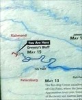
 view gallery view galleryN3.7 km | Drewry's Bluff - Richmond VA in U.S. Civil War Sites Drewry’s Bluff 1862-As capital of the Confederate States of America, Richmond, Virginia, became the constant target of Northern armies. It was vulnerable by water as well as by land. Gunboats could navigate the James River all the way to Richmond. posted by: Don.Morfe location: Virginia date approved: 09/16/2020 last visited: 10/02/2021 |
 view gallery view galleryN3.7 km | Drewry's Bluff - Richmond VA in American Civil War Monuments and Memorials Drewry’s Bluff 1862-As capital of the Confederate States of America, Richmond, Virginia, became the constant target of Northern armies. It was vulnerable by water as well as by land. Gunboats could navigate the James River all the way to Richmond. posted by: Don.Morfe location: Virginia date approved: 03/10/2024 last visited: 03/10/2024 |
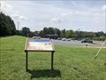
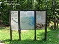
 view gallery view galleryN3.7 km |  'You Are Here' Map-Drewry's Bluff - Richmond VA 'You Are Here' Map-Drewry's Bluff - Richmond VA
in 'You Are Here' Maps 'You Are Here' Map in the left panel shows that you are at Drewry's Bluff in Richmond VA. posted by: Don.Morfe location: Virginia date approved: 03/09/2024 last visited: 03/09/2024 |
 view gallery view galleryN3.7 km |  Drewry's Bluff - Richmond VA Drewry's Bluff - Richmond VA
in Signs of History Drewry’s Bluff 1862-As capital of the Confederate States of America, Richmond, Virginia, became the constant target of Northern armies. It was vulnerable by water as well as by land. Gunboats could navigate the James River all the way to Richmond. posted by: Don.Morfe location: Virginia date approved: 03/09/2024 last visited: 03/09/2024 |
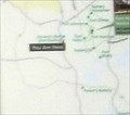
 view gallery view galleryN3.7 km | 'You Are Here' Map-Drewry's Bluff - Richmond VA[ in 'You Are Here' Maps You Are Here' Map in the right panel shows that you are at Drewry's Bluff in Richmond VA. posted by: Don.Morfe location: Virginia date approved: 03/09/2024 last visited: 03/09/2024 |
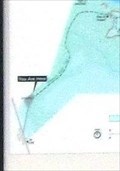
 view gallery view galleryN3.7 km | 'You Are Here' Map-Drewry's Bluff - Richmond VA in 'You Are Here' Maps You Are Here' Map in the center panel shows that you are at Drewry's Bluff in Richmond VA. posted by: Don.Morfe location: Virginia date approved: 03/09/2024 last visited: 03/09/2024 |
 view gallery view gallery NE3.9 km NE3.9 km
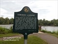
| Osborne Landing in Virginia Historical Markers Osborne Landing was located near here along the north bank of the James River across from the Village of Osborne in Chesterfield County. posted by: Don.Morfe location: Virginia date approved: 04/01/2020 last visited: 10/20/2021 |
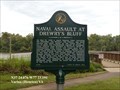 view gallery view galleryNE3.9 km | Naval Assault at Drewry’s Bluff in Virginia Historical Markers On May 15, 1862 a small federal fleet including the ironclads, the Monitor, the Galena, and three wooden war ships sailed up the James River to try to enter the Confederate capital at Richmond. posted by: Don.Morfe location: Virginia date approved: 07/07/2020 last visited: 10/20/2021 |
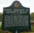 view gallery view galleryNE3.9 km | Naval Assault at Drewry’s Bluff - Henrico VA in American Civil War Monuments and Memorials On May 15, 1862 a small federal fleet including the ironclads, the Monitor, the Galena, and three wooden war ships sailed up the James River to try to enter the Confederate capital at Richmond. posted by: Don.Morfe location: Virginia date approved: 03/17/2023 last visited: 03/15/2023 |
 view gallery view galleryNE3.9 km | Osborne Landing Captain John Smith’s Adventures on the James - Varina, VA in Signs of History The Arrohateck Indians lived along the James River north of the Appomattox. They met Smith and his comrades on their initial journey up the James, paddling out to meet the English on a small island. posted by: Don.Morfe location: Virginia date approved: 01/27/2020 last visited: 09/25/2021 |
 view gallery view galleryN3.9 km | A Perfect Gibraltar - Richmond VA in American Civil War Monuments and Memorials After the repulse of the Union Navy on May 15, 1862, Drewry’s Bluff became famous as a tangible symbol of Confederate resistance. posted by: Don.Morfe location: Virginia date approved: 03/10/2024 last visited: 03/10/2024 |
 view gallery view galleryN3.9 km | A Perfect Gibraltar - Richmond VA in Signs of History After the repulse of the Union Navy on May 15, 1862, Drewry’s Bluff became famous as a tangible symbol of Confederate resistance. posted by: Don.Morfe location: Virginia date approved: 03/09/2024 last visited: 03/09/2024 |
 view gallery view galleryN3.9 km | A Perfect Gibraltar - Richmond VA in U.S. Civil War Sites After the repulse of the Union Navy on May 15, 1862, Drewry’s Bluff became famous as a tangible symbol of Confederate resistance. posted by: Don.Morfe location: Virginia date approved: 09/16/2020 last visited: 10/02/2021 |
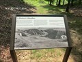
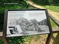 view gallery view galleryN3.9 km | Finishing Fort Drewry in U.S. Civil War Sites Drewry’s Bluff- Immediately after the battle, men of Chesterfield County’s own Southside Artillery, along with others, worked to strengthen the fort. The section before you was likely their first project. posted by: Don.Morfe location: Virginia date approved: 09/16/2020 last visited: 10/02/2021 |
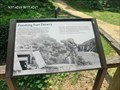 view gallery view galleryN3.9 km | Finishing Fort Drewry -Richmond VA in American Civil War Monuments and Memorials Drewry’s Bluff- Immediately after the battle, men of Chesterfield County’s own Southside Artillery, along with others, worked to strengthen the fort. The section before you was likely their first project. posted by: Don.Morfe location: Virginia date approved: 03/17/2024 last visited: 03/17/2024 |
|