 view gallery view gallery NE5.6 km NE5.6 km
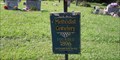
|   Methodist Cemetery, Brodhead, Kentucky Methodist Cemetery, Brodhead, Kentucky
in Worldwide Cemeteries Small community cemetery serving the town of Broadhead, Kentucky. Founded in 1896 posted by:  PersonsMD PersonsMD location: Kentucky date approved: 08/31/2009 last visited: 10/09/2013 |
 view gallery view gallery E10.5 km E10.5 km
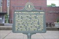
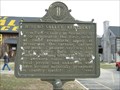
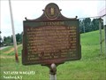
|  Rockcastle County, 1810 Rockcastle County, 1810
in Kentucky Historical Markers Located in front of the courthouse on E. Main St and Church St. posted by: Markerman62 location: Kentucky date approved: 05/24/2016 last visited: 02/17/2019 |
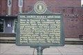 view gallery view galleryE10.5 km | Col. James Maret (1855- 1936)/Boone Way in Kentucky Historical Markers Located on Main St and Church St at the courthouse posted by: Markerman62 location: Kentucky date approved: 05/24/2016 last visited: 05/21/2016 |
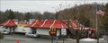 view gallery view galleryE10.6 km |  McDonalds - I-75 Exit 62 - Mt. Vernon, KY McDonalds - I-75 Exit 62 - Mt. Vernon, KY
in McDonald's Restaurants Older McD's just under a mile to the west of the interstate posted by: vhasler location: Kentucky date approved: 02/02/2014 last visited: never |
 view gallery view galleryE10.6 km |  Rockcastle Regional Hospital Landing Pad, Mount Vernon, Kentucky Rockcastle Regional Hospital Landing Pad, Mount Vernon, Kentucky
in Helicopter Landing Pads A landing pad providing service to the citizens of the region and access to the Rockcastle Regional Hospital and emergency services department. posted by: PersonsMD location: Kentucky date approved: 10/29/2010 last visited: 10/15/2013 |
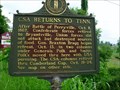 view gallery view galleryE11.1 km | CSA Returns to Tenn. in Kentucky Historical Markers Located at Mt. Vernon on US 25, 150 posted by:  Sprinterman Sprinterman location: Kentucky date approved: 06/28/2009 last visited: 07/25/2023 |
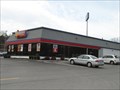 view gallery view galleryE11.3 km |  Hardee's - Renfro Valley, KY Hardee's - Renfro Valley, KY
in Carl's Jr./Hardee's Restaurants Located off I-75 Exit 62 posted by: vhasler location: Kentucky date approved: 04/02/2009 last visited: never |
 view gallery view galleryE11.3 km |  Star block - Renfro Valley, KY Star block - Renfro Valley, KY
in Painted Barn Quilts Located south of the Renfro Valley Barn Dance center posted by: vhasler location: Kentucky date approved: 04/02/2009 last visited: 10/15/2013 |
 view gallery view galleryE11.4 km |  Wilderness Road Heritage Highway - Renfro Valley Entertainment Center, KY Wilderness Road Heritage Highway - Renfro Valley Entertainment Center, KY
in National Scenic Byways This center is for the preservation of country and mountain music. posted by: vhasler location: Kentucky date approved: 02/19/2009 last visited: 10/15/2013 |
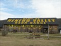
 view gallery view galleryE11.4 km |  Kentucky Music Hall of Fame - Renfro Valley, KY Kentucky Music Hall of Fame - Renfro Valley, KY
in Hall of Fame A small museum dedicated to musicians from the Bluegrass State. posted by: OmegaLimit location: Kentucky date approved: 10/13/2009 last visited: 10/15/2013 |
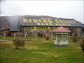 view gallery view galleryE11.4 km |  Renfro Valley, KY Renfro Valley, KY
in Dixie Highway Located along the route of the Dixie Highway, here is the site of the Renfro Valley Barn Dance, a radio broadcast started in the November of 1939. posted by: kbarhow location: Kentucky date approved: 11/08/2008 last visited: 07/04/2013 |
 view gallery view galleryE11.4 km | Renfro Valley, Kentucky - Renfro Valley, KY in Kentucky Historical Markers Radio broadcasts from Renfro Valley featured early country music. posted by: vhasler location: Kentucky date approved: 02/19/2009 last visited: 10/15/2013 |
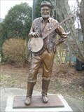 view gallery view galleryE11.4 km |  Old Joe Clark - Renfro Valley, KY Old Joe Clark - Renfro Valley, KY
in Musician Statues Old Joe Clark performed banjo and comedy in Renfro Valley for half a century. posted by: vhasler location: Kentucky date approved: 02/04/2011 last visited: 10/15/2013 |
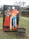 view gallery view galleryE11.4 km |  Country Music Singers photo cutout - Renfro Valley, KY Country Music Singers photo cutout - Renfro Valley, KY
in Photo Cutouts Photo cutout near the old barn theater for Renfro Valley Barn Dance posted by: vhasler location: Kentucky date approved: 02/19/2009 last visited: never |
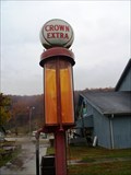 view gallery view galleryE11.4 km |  Crown Extra Pump - Renfro Valley Village, KY Crown Extra Pump - Renfro Valley Village, KY
in Vintage Gasoline Pumps Old pump on display in a period village along the Dixie Highway. This is the location of the Renfro Valley Barn Dance. posted by: kbarhow location: Kentucky date approved: 11/10/2008 last visited: 10/20/2012 |
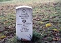
 view gallery view gallery N11.9 km N11.9 km
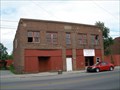
|  IOOF 108, Crab Orchard, KY IOOF 108, Crab Orchard, KY
in Odd Fellow Lodges Old long gone lodge building in central Kentucky. posted by: kbarhow location: Kentucky date approved: 05/28/2009 last visited: 08/17/2014 |
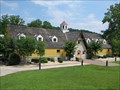
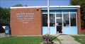 view gallery view galleryN12.1 km |  Crab Orchard Post Office, Crab Orchard, Kentucky 40419 Crab Orchard Post Office, Crab Orchard, Kentucky 40419
in U.S. Post Offices A small community post office located in the town of Crab Orchard, Kentucky Zip Code is 40419 posted by: PersonsMD location: Kentucky date approved: 08/29/2009 last visited: 10/09/2013 |
 view gallery view gallery NW12.2 km NW12.2 km
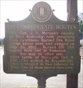
| On Confederate Routes, Crab Orchard, Kentucky in Kentucky Historical Markers A marker noting the passing of Confederate troups through this area during the American Civil War. posted by: PersonsMD location: Kentucky date approved: 08/30/2009 last visited: 10/16/2013 |
 view gallery view galleryNW19 km | Ottenheim - Stanford KY in Kentucky Historical Markers A German-Swiss settlement, 4 miles southeast, started by immigrants, early 1880s. posted by: Don.Morfe location: Kentucky date approved: 03/30/2020 last visited: 10/20/2021 |
 view gallery view galleryE21.7 km |  David M. Smith-Livingston, KY David M. Smith-Livingston, KY
in Medal Of Honor Resting Places Korean War Medal of Honor Recipient for action near Yongsan, Korea on September 1, 1950. He was killed in action. He is buried in Smith Cemetery on the Hill Ponder, Livingston, KY. posted by: Don.Morfe location: Kentucky date approved: 01/22/2018 last visited: 12/17/2021 |
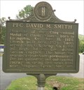 view gallery view galleryE21.7 km | PFC David M. Smith & Medal of Honor Winner, Livingston, Kentucky in Kentucky Historical Markers Marker honoring the service of American hero and Medal of Honor recipient David M. Smith. posted by: PersonsMD location: Kentucky date approved: 08/29/2009 last visited: 05/17/2016 |
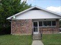 view gallery view galleryE22.4 km | Livingston, Kentucky 40445 in U.S. Post Offices A small community Post Office in the deep green woods of Kentucky. posted by: PersonsMD location: Kentucky date approved: 08/28/2009 last visited: 10/09/2013 |
 view gallery view galleryE22.5 km |  Livingston Trail Head Four Historic Plaques - Livingston, KY Livingston Trail Head Four Historic Plaques - Livingston, KY
in Ancient Traces and Roads Marker is on Daniel Boone Trail (U.S. 25) near Upper River Road (Kentucky Route 490), on the right when traveling north. marker is in a small park that serves as a trail head. It at the south west corner of the intersection. posted by: Crazy4horses location: Kentucky date approved: 03/20/2023 last visited: never |
 view gallery view galleryE22.5 km |  Livingston Trail Head Four Historic Plaques - Livingston, KY, USA Livingston Trail Head Four Historic Plaques - Livingston, KY, USA
in Daughters of the American Revolution Marker in on Daniel Boone Trail (U.S. 25) near (Kentucky Route 490) in a small park that serves as a trail head. The four plaques are on a pink granite monument. The plaques do not contain the DAR insignia. posted by: Crazy4horses location: Kentucky date approved: 05/27/2023 last visited: never |
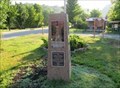
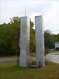 view gallery view galleryE22.5 km |  Livingston, KY 9/11 Memorial Livingston, KY 9/11 Memorial
in 9/11 Memorial Sites Memorial located in a small rural community in southern Kentucky, along the Dixie Highway and Wilderness Road route. posted by: kbarhow location: Kentucky date approved: 09/17/2009 last visited: 10/20/2012 |
|