 view gallery view gallery S9.7 km S9.7 km
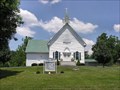
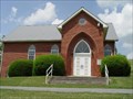
|   Pisgah United Methodist Church - Tazewell, Virginia Pisgah United Methodist Church - Tazewell, Virginia
in Country Churches Absolutely a beautiful church. Picture perfect and it was just as beautiful a day to visit. Nice yard with picnic shelter and a outdoor open meeting area too.
The light house was an added bonus. posted by:  UberHOKIE UberHOKIE location: Virginia date approved: 07/16/2008 last visited: 06/19/2010 |
 view gallery view galleryS9.7 km |  268 - Pisgah United Methodist Church- Tazewell Virginia 268 - Pisgah United Methodist Church- Tazewell Virginia
in Historic United Methodist Sites Pisgah United Methodist Church is the oldest Methodist congregation in Tazewell County, Virginia. Historical records also signify Pisgah Church was the first church, of any denomination, in the county. posted by: UberHOKIE location: Virginia date approved: 07/16/2008 last visited: 12/07/2016 |
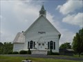 view gallery view galleryS9.7 km | Pisgah United Methodist Church - Tazewell, Virginia in This Old Church The Pisgah United Methodist Church is one of the oldest congregations in Southwest Virginia. posted by:  Sneakin Deacon Sneakin Deacon location: Virginia date approved: 05/22/2007 last visited: never |
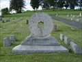 view gallery view galleryS9.7 km |  S. Alex Witten S. Alex Witten
in Occupational/Hobby Grave Stones Alex Witten operated Witten's Mill in Tazewell County, Virginia. His Grave is marked by a mill stone that was used at the mill for 54 years. posted by: Sneakin Deacon location: Virginia date approved: 07/18/2006 last visited: never |
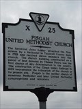 view gallery view galleryS9.8 km |  Pisgah United Methodist Church Pisgah United Methodist Church
in Virginia Historical Markers This historic marker is located on U. S. Route 460 in front of the Pisgah United Methodist Church, west of Tazewell Virginia. posted by: Sneakin Deacon location: Virginia date approved: 05/24/2007 last visited: never |
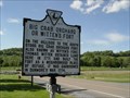 view gallery view galleryS10 km | Witten's Fort in Virginia Historical Markers Fort Witten or Big Crab Orchard Fort posted by: Sneakin Deacon location: Virginia date approved: 06/05/2006 last visited: 09/21/2006 |
 view gallery view gallery SE10.1 km SE10.1 km
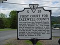
| First Court for Tazewell County in Virginia Historical Markers The first court session in Tazewell County was held near here in 1800. posted by: Sneakin Deacon location: Virginia date approved: 06/09/2006 last visited: never |
 view gallery view gallerySE10.6 km |  Tazewell High School Bulldogs - Tazewell, Virginia Tazewell High School Bulldogs - Tazewell, Virginia
in School Mascots This bulldog statue stands in front of Tazewell High School in Tazewell, Virginia posted by: Sneakin Deacon location: Virginia date approved: 06/24/2010 last visited: never |
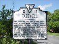 view gallery view galleryS10.9 km | Tazewell in Virginia Historical Markers The Town of Tazewell is the county seat of Tazewell County, Virginia posted by: Sneakin Deacon location: Virginia date approved: 06/05/2006 last visited: never |
 view gallery view galleryS10.9 km |  Tazewell County Confederate Memorial - Tazewell, Virginia Tazewell County Confederate Memorial - Tazewell, Virginia
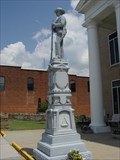
in American Civil War Monuments and Memorials The Tazewell County Confederate Memorial is located in front of the Tazewell County Courthouse in Tazewell, Virginia posted by: Sneakin Deacon location: Virginia date approved: 06/16/2007 last visited: never |
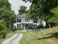
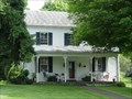 view gallery view galleryS11.1 km |  Wynn, James, House - Tazewell, Virginia Wynn, James, House - Tazewell, Virginia
in U.S. National Register of Historic Places The James Wynn House is located just off of Main Street in Tazewell, Virginia posted by: Sneakin Deacon location: Virginia date approved: 06/16/2007 last visited: never |
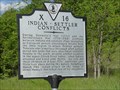 view gallery view galleryS11.9 km | Indian - Settler Conflicts in Virginia Historical Markers Earlier pioneer in the western frontier of Virginia face numerous challenges including attacks by Indians. posted by: Sneakin Deacon location: Virginia date approved: 06/05/2006 last visited: never |
 view gallery view gallery SW11.9 km SW11.9 km
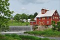
|  Taylor's Mill - Maxwell, Virginia Taylor's Mill - Maxwell, Virginia
in Water Mills Taylor's Mill is located on the banks of the Clinch River in Tazewell County, Va. posted by: Sneakin Deacon location: Virginia date approved: 06/10/2012 last visited: never |
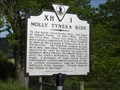 view gallery view gallerySE12.4 km | Molly Tyne's Ride in Virginia Historical Markers The Midnight Ride of Molly Tynes during the Civil War. posted by: Sneakin Deacon location: Virginia date approved: 06/06/2006 last visited: never |
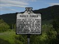 view gallery view gallerySE12.4 km | Burke's Garden in Virginia Historical Markers Burke's Garden also known as God's thumbprint. posted by: Sneakin Deacon location: Virginia date approved: 06/09/2006 last visited: never |
 view gallery view galleryS14.5 km | Thompson Valley Presbyterian Church - Thompson Valley, Virginia in Country Churches The Thompson Valley Presbyterian Church is located in the Thompson Valley Community of Tazewell County, Virginia posted by: Sneakin Deacon location: Virginia date approved: 06/24/2007 last visited: never |
 view gallery view gallery NW15.1 km NW15.1 km
|  War. WV. 24892 War. WV. 24892
in U.S. Post Offices War West Virginia Post Office posted by: dukemartin location: West Virginia date approved: 07/19/2012 last visited: never |
 view gallery view galleryS15.3 km | Thompson, George Oscar, House - Thompson Valley, Virginia in U.S. National Register of Historic Places The G. O. Thompson House is located on Route 604 the the Thompson Valley Community of Tazewell County, Virginia posted by: Sneakin Deacon location: Virginia date approved: 06/16/2007 last visited: never |
 view gallery view galleryS15.8 km | Pleasant Hill United Methodist Church - Thompson Valley, Virginia in Country Churches Pleasant Hill Methodist Church is located in the Thompson Valley Community of Tazewell County, Virginia posted by: Sneakin Deacon location: Virginia date approved: 06/24/2007 last visited: never |
 view gallery view gallery E19.2 km E19.2 km
| Shawver's Mill in Virginia Historical Markers The history of Shawver's Mill and the community the grew up around it. posted by: Sneakin Deacon location: Virginia date approved: 06/06/2006 last visited: never |
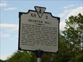
 view gallery view gallerySE20.3 km | Burke's Garden in Virginia Historical Markers Burke's Garden is known as "God's Thumbprint" and is one of the most beautiful areas of Tazewell County, Virginia posted by: Sneakin Deacon location: Virginia date approved: 06/16/2007 last visited: never |
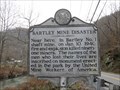 view gallery view galleryNW21.7 km |  Bartley Mine Disaster Bartley Mine Disaster
in West Virginia Historical Markers Ninety one miners died here January 10, 1940. posted by: dukemartin location: West Virginia date approved: 11/27/2018 last visited: never |
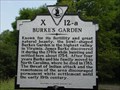
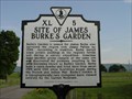 view gallery view gallerySE22 km | Site of James Burke's Garden in Virginia Historical Markers Burke's Garden is one of the most beautiful places in Southwest Virginia and remains on of the most fertile farming community's in Virginia. posted by: Sneakin Deacon location: Virginia date approved: 06/16/2007 last visited: never |
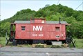 view gallery view gallery NE22.2 km NE22.2 km
|  N&W Caboose #530302 - Pocahontas, Va. N&W Caboose #530302 - Pocahontas, Va.
in Train Cabooses N & W Caboose #530302 is located in the Pocahontas Town Park in Pocahontas, Virginia posted by: Sneakin Deacon location: Virginia date approved: 06/13/2012 last visited: never |
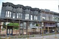 view gallery view galleryNE22.2 km | Pocahontas Historic District - Pocahontas, Virginia in U.S. National Register of Historic Places The small town of Pocahontas, Virginia I all but abandoned today. Home to less than 500 residents. posted by: Sneakin Deacon location: Virginia date approved: 06/08/2012 last visited: 10/29/2016 |
|