 view gallery view gallery NW13.4 km NW13.4 km
|   HG0448 Coldwater 1934 - Coldwater, KS HG0448 Coldwater 1934 - Coldwater, KS
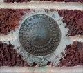
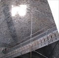
in U.S. Benchmarks This U.S. Coast and Geodetic Survey Disk is set in the red brick wall of the Coldwater National Bank, in Coldwater, Kansas. posted by:  The Snowdog The Snowdog location: Kansas date approved: 01/03/2021 last visited: never |
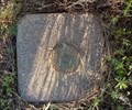 view gallery view galleryNW14.2 km | COLDWATER (HG1043) - Coldwater, KS in U.S. Benchmarks This triangulation station is on the west edge of Coldwater, Kansas. posted by: The Snowdog location: Kansas date approved: 04/15/2024 last visited: never |
 view gallery view gallery N25.4 km N25.4 km
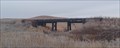
|  Railroad Bridge - Kiowa County, KS Railroad Bridge - Kiowa County, KS
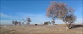
in Railroad Bridges This (former) railroad bridge is in southeast Kiowa County, Kansas. posted by: The Snowdog location: Kansas date approved: 11/20/2022 last visited: never |
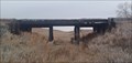 view gallery view galleryN25.4 km |  Railroad Bridge - Kiowa County, KS Railroad Bridge - Kiowa County, KS
in Orphaned Bridges This former railroad bridge is in southeast Kiowa County, Kansas posted by: The Snowdog location: Kansas date approved: 11/20/2022 last visited: never |
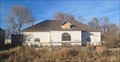 view gallery view gallery W39.9 km W39.9 km
|  Sitka Social Club - Sitka, KS Sitka Social Club - Sitka, KS
in Unoccupied Buildings, Shacks, and Cabins Once the center of activity, the Sitka Social Club is abandoned and falling into ruin - in Sitka, Kansas. posted by: The Snowdog location: Kansas date approved: 12/28/2022 last visited: never |
 view gallery view galleryW39.9 km |  Sitka, KS Sitka, KS
in Ghost Towns Once a water stop on the railroad, Sitka is now a ghost town - in Clark County, Kansas. posted by: The Snowdog location: Kansas date approved: 12/28/2022 last visited: never |
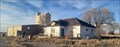
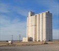 view gallery view galleryW40.1 km | SITKA WALLINGFORD GRAIN ELEV (HG0972) - Sitka, KS in U.S. Benchmarks The Sitka / Wallingford Grain Elevator is almost all that remains of the ghost town of Sitka, Kansas. posted by: The Snowdog location: Kansas date approved: 12/28/2022 last visited: never |
 view gallery view galleryW40.1 km |  Siska / Wallingford Grain Elevator - Siska, KS Siska / Wallingford Grain Elevator - Siska, KS
in Grain Elevators This grain elevator serves farmers in the area of Sitka, Kansas. posted by: The Snowdog location: Kansas date approved: 12/28/2022 last visited: never |
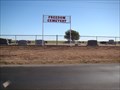 view gallery view gallery S41.5 km S41.5 km
|  Freedom Cemetery - Freedom, OK Freedom Cemetery - Freedom, OK
in Worldwide Cemeteries Cemetery in rural Freedom, OK, west of Alva posted by: Max and 99 location: Oklahoma date approved: 11/09/2010 last visited: never |
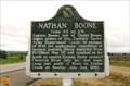 view gallery view galleryS43.8 km |  Nathan Boone Nathan Boone
in Oklahoma Historical Markers Daniel Boone's youngest child. He built the Boone's Lick Road in Missouri, with William Clark, helped settle the Honey Wars and Missouri's border dispute with Iowa, and negotiated many Indian treaty. posted by: YoSam. location: Oklahoma date approved: 05/29/2010 last visited: 07/06/2018 |
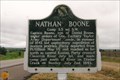 view gallery view galleryS43.8 km |  Nathan Boone - near Freedom, OK Nathan Boone - near Freedom, OK
in Citizen Memorials Daniel Boone's youngest child. He built the Boone's Lick Road in Missouri, with William Clark, helped settle the Honey Wars and Missouri's border dispute with Iowa, and negotiated many Indian treaty. posted by: YoSam. location: Oklahoma date approved: 12/10/2022 last visited: never |
 view gallery view gallery SW43.8 km SW43.8 km
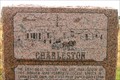
| Charleston, OK in Ghost Towns Once a bustling town, and now only the weeds bustle from the wind. posted by: YoSam. location: Oklahoma date approved: 05/25/2010 last visited: 03/24/2012 |
 view gallery view gallerySW43.8 km |  Charleston, Oklahoma Charleston, Oklahoma
in Wikipedia Entries Where once was a bustling town, now only the weeds bustle from the wind. People moved in, then people moved on. posted by: YoSam. location: Oklahoma date approved: 12/10/2021 last visited: never |
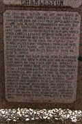 view gallery view gallerySW43.8 km |  FIRST - School, Postmaster, Post Office, Merchant - Charleston, OK FIRST - School, Postmaster, Post Office, Merchant - Charleston, OK
in First of its Kind Where once was a bustling town, now only the weeds bustle from the wind. People moved in, the people moved on. posted by: YoSam. location: Oklahoma date approved: 12/10/2021 last visited: never |
 view gallery view gallerySW43.8 km | Charleston in Oklahoma Historical Markers Where once was a bustling town, now only the weeds bustle from the wind. posted by: YoSam. location: Oklahoma date approved: 05/26/2010 last visited: 03/24/2012 |
 view gallery view gallerySW43.8 km |  Charleston, Oklahoma Charleston, Oklahoma
in Human Migration Monuments Where once was a bustling town, now only the weeds bustle from the wind. People moved in, then people moved on. posted by: YoSam. location: Oklahoma date approved: 12/18/2021 last visited: never |
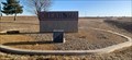
 view gallery view gallerySW44.1 km |  State Line Park - Harper County, OK State Line Park - Harper County, OK
in Highway Rest Areas State Line Park is on the east side of US 183, just south of the Oklahoma / Kansas border - in Harper County, Oklahoma. posted by: The Snowdog location: Oklahoma date approved: 12/28/2022 last visited: never |
 view gallery view gallerySW44.1 km |  Oklahoma / Kansas on US 183 - north of Buffalo, OK Oklahoma / Kansas on US 183 - north of Buffalo, OK
in Border Crossings US 183 joins Oklahoma and Kansas at a small roadside park - north of Buffalo, Oklahoma. posted by: The Snowdog location: Oklahoma date approved: 12/28/2022 last visited: never |
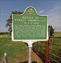 view gallery view galleryS44.7 km | Battle of Turkey Springs - NE of Freedom, OK in Oklahoma Historical Markers A historical marker describing an engagement between U.S. troops and Northern Cheyenne Indians. posted by: The Snowdog location: Oklahoma date approved: 07/09/2018 last visited: never |
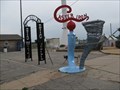
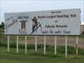
 view gallery view galleryN45.5 km |  The World's Largest Hand-Dug Well, Greensburg, Kansas The World's Largest Hand-Dug Well, Greensburg, Kansas
in Superlatives The Largest Hand-Dug well in the world can be found in Greensburg, Kansas. posted by: Queens Blessing location: Kansas date approved: 06/06/2010 last visited: 07/04/2019 |
 view gallery view galleryN45.5 km |  Responders Recall Kansas Tornado Devastation, Greensburg KS Responders Recall Kansas Tornado Devastation, Greensburg KS
in News Article Locations Greensburg, Kansas was devastaed by a tornado 1.7 miles wide on May 4, 2007; some Emergency Responders remember the day. posted by: Queens Blessing location: Kansas date approved: 06/06/2010 last visited: 05/10/2010 |
 view gallery view galleryN45.5 km |  The Big Well & the Meteorite - Greensburg, Kansas The Big Well & the Meteorite - Greensburg, Kansas
in Roadside Attractions The Roadside America website lists the well and meterite in Greensburg as attractions. posted by: Queens Blessing location: Kansas date approved: 08/06/2010 last visited: 07/04/2019 |
 view gallery view galleryN45.5 km |  Kiowa County Courthouse - Greensburg, KS Kiowa County Courthouse - Greensburg, KS
in Picture Perfect Postcards Front and back of card provided in gallery. posted by: YoSam. location: Kansas date approved: 05/06/2019 last visited: 07/04/2019 |
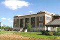 view gallery view galleryN45.5 km |  Kiowa County Courthouse ~ Greensburg, KS Kiowa County Courthouse ~ Greensburg, KS
in Courthouses Recently remodeled because of a tornado that nearly destroyed the entire town. posted by: YoSam. location: Kansas date approved: 01/21/2011 last visited: 07/04/2019 |
 view gallery view galleryN45.5 km |  1914 - Kiowa County Courthouse ~ Greensburg, KS 1914 - Kiowa County Courthouse ~ Greensburg, KS
in Dated Buildings and Cornerstones Remodeled in 2009 because of tornado damage. Tornado nearly wiped out the entire town. posted by: YoSam. location: Kansas date approved: 01/20/2011 last visited: 07/04/2019 |
|