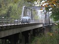
 view gallery view gallery W5.5 km W5.5 km
|   Highway 51 - Zalma, Missouri Highway 51 - Zalma, Missouri
in Truss Bridges Highway 51 bridge crossing the Castor River, just inside the city limits of Zalma. posted by:  gparkes gparkes location: Missouri date approved: 10/14/2009 last visited: never |
 view gallery view galleryW5.5 km |  Zalma, Missouri Zalma, Missouri
in 'Z' Welcome Signs This small town in southern Missouri has the nickname of Z-Town. posted by: gparkes location: Missouri date approved: 10/14/2009 last visited: never |
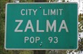
 view gallery view galleryW5.5 km |  Zalma, Missouri Zalma, Missouri
in Population Signs This small town in southern Missouri has the nickname of Z-Town. posted by: gparkes location: Missouri date approved: 10/14/2009 last visited: never |
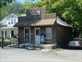 view gallery view gallery NE13.8 km NE13.8 km
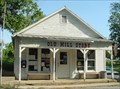
|  Leopold, Missouri, 63760 Leopold, Missouri, 63760
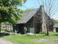
in U.S. Post Offices Post office in the rural community of Leopold, Missouri. posted by:  paulspaper paulspaper location: Missouri date approved: 10/13/2007 last visited: never |
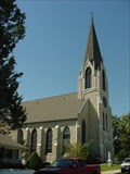 view gallery view galleryNE13.8 km |  St. John's Church and Shrine - Leopold, MO St. John's Church and Shrine - Leopold, MO
in Roman Catholic Churches Built in 1901, St. John's is a fine example of German architecture with stained glass windows and arches. It has one of the oldest pipe organs west of the Mississippi River. posted by: paulspaper location: Missouri date approved: 10/13/2007 last visited: never |
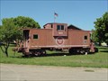 view gallery view gallery N16.4 km N16.4 km
|  Missouri Pacific Caboose - Marble Hill, Missouri Missouri Pacific Caboose - Marble Hill, Missouri
in Train Cabooses A Missouri Pacific Caboose. posted by: paulspaper location: Missouri date approved: 10/13/2007 last visited: never |
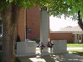 view gallery view galleryN17.2 km |  Bollinger County War Memorial Bollinger County War Memorial
in Non-Specific Veteran Memorials War Memorial dedicated to Bollinger County citizens killed during the Civil War, WWI, WWII, Korean War and Vietnam War. posted by: paulspaper location: Missouri date approved: 10/14/2007 last visited: never |
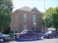 view gallery view galleryN17.2 km |  Bollinger County Courthouse Bollinger County Courthouse
in Courthouses 1885 courthouse built from stone quarried in Bollinger County and containing antique interior appointments. Exhibits the work of local artists. posted by: paulspaper location: Missouri date approved: 10/12/2007 last visited: never |
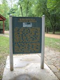
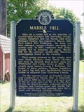 view gallery view galleryN17.2 km |  Marble Hill Marble Hill
in Missouri Historical Markers Historical marker about Marble Hill and the surrounding area. Found on the Bollinger County Courthouse grounds in Marble Hill, Missouri. posted by: paulspaper location: Missouri date approved: 10/17/2007 last visited: never |
 view gallery view galleryN17.2 km |  Massey House Historical Museum - Marble Hill, Missouri Massey House Historical Museum - Marble Hill, Missouri
in History Museums Historical museum operated by the Bollinger County Historical Society. posted by: paulspaper location: Missouri date approved: 10/13/2007 last visited: never |
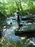 view gallery view galleryN17.4 km |  Marble Hill Artesian Spring Marble Hill Artesian Spring
in Artesian Well A nice clear, cold artesian spring in a wooded area. posted by: paulspaper location: Missouri date approved: 10/13/2007 last visited: never |
 view gallery view galleryN17.5 km |  Mayfield, Will, College Arts and Science Building - Marble Hill, MO Mayfield, Will, College Arts and Science Building - Marble Hill, MO
in U.S. National Register of Historic Places Will Mayfield College, established in Marble Hill in 1884 when the first two-story building was completed served the community until it was closed in 1934 due to financial difficulties. posted by: paulspaper location: Missouri date approved: 10/13/2007 last visited: never |
 view gallery view galleryN17.5 km | Bollinger County Museum of Natural History - Marble Hill, MO in Science Museums Home of the Missouri Dinosaur. The museum displays dinosaur artifacts from the local dinosaur dig; American Indian artifacts; Will Mayfield College artifacts; and alternating exhibits. posted by: paulspaper location: Missouri date approved: 10/13/2007 last visited: never |
 view gallery view gallery SW23.8 km SW23.8 km
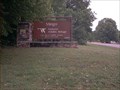
|  Mingo National Wildlife Refuge - Missouri Mingo National Wildlife Refuge - Missouri
in National Wildlife Refuges One of the last swamps in the Mississippi River floodplain, now separated from the Mississippi by the Crowley Ridge terrace. The only remaining large tract of bottomland forest(15,000 acres) of the 2.5 million acres that once existed in the bootheel posted by: Satchamo 44 location: Missouri date approved: 06/09/2007 last visited: never |
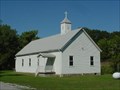 view gallery view galleryNE27.2 km | Gravel Hill United Methodist Church - MO in Country Churches Rural church in Southeast Missouri. posted by: paulspaper location: Missouri date approved: 10/13/2007 last visited: never |
 view gallery view galleryNE30.1 km | Burfordville, Missouri, 63739 in U.S. Post Offices Post office Burfordville, Missouri. Located at 353 State Highway HH, Burfordville, MO, 63739-9998 posted by: paulspaper location: Missouri date approved: 10/11/2007 last visited: 11/22/2009 |
 view gallery view galleryNE30.1 km | Burfordville Covered Bridge/Bollinger Mill - Burfordville, Mo. in Missouri Historical Markers This Historical Marker is located within the Bollinger Mill State Park - 113 Bollinger Mill Road in Burfordville. Mo. posted by: iconions location: Missouri date approved: 10/05/2011 last visited: never |
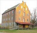
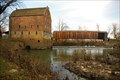
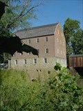 view gallery view galleryNE30.3 km |  Bollinger Mill, Burfordville, Missouri Bollinger Mill, Burfordville, Missouri
in Water Mills Bollinger Mill is a massive four-story stone and brick building where visitors can still observe corn being ground into meal by water power - just as it was done long ago. posted by: paulspaper location: Missouri date approved: 10/14/2007 last visited: 09/27/2011 |
 view gallery view galleryNE30.3 km |  Cape County Milling Company - Bollinger Mill Burfordville, Missouri Cape County Milling Company - Bollinger Mill Burfordville, Missouri
in Ghost Signs Cape County Milling Company - Bollinger Mill Burfordville, Missouri posted by: kJfishman location: Missouri date approved: 12/18/2009 last visited: 09/24/2011 |
 view gallery view galleryNE30.3 km | Burfordville Mill in U.S. National Register of Historic Places Burfordville Mill, known as Bollinger Mill, is a massive four-story stone and brick building where visitors can still observe corn being ground into meal by water power - just as it was done long ago.
posted by: paulspaper location: Missouri date approved: 10/13/2007 last visited: 09/24/2011 |
 view gallery view galleryNE30.3 km |  Bollinger Mill State Historic Site - Bollinger MO Bollinger Mill State Historic Site - Bollinger MO
in Civil War Discovery Trail Sites The Mill was burnt down by the Union Army to prevent flour and meal to be sent to the Confederate Army. posted by: kJfishman location: Missouri date approved: 04/09/2016 last visited: 09/24/2011 |
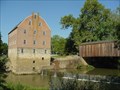
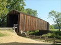 view gallery view galleryNE30.3 km |  Burfordville Covered Bridge - Burfordville, Missouri Burfordville Covered Bridge - Burfordville, Missouri
in Covered Bridges Burfordville Covered Bridge is the oldest remaining covered bridge in Missouri. Located in Bollinger Mill State Historic Site. posted by: paulspaper location: Missouri date approved: 10/12/2007 last visited: 09/24/2011 |
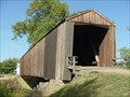 view gallery view galleryNE30.3 km | Burfordville Covered Bridge in U.S. National Register of Historic Places Burfordville Covered Bridge is the oldest remaining covered bridge in Missouri. Located in Bollinger Mill State Historic Site. posted by: paulspaper location: Missouri date approved: 10/13/2007 last visited: 09/24/2011 |
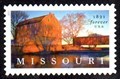 view gallery view galleryNE30.3 km |  Bollinger Mill and Covered Bridge, Burfordville, MO Bollinger Mill and Covered Bridge, Burfordville, MO
in Philatelic Photographs A view of Bollinger Mill State Historic Site graces this 2021 postage stamp commemorating the State of Missouri’s 200th anniversary. posted by: hykesj location: Missouri date approved: 08/29/2021 last visited: never |
 view gallery view galleryNE30.3 km |  Bollinger Mill State Historic Site - Bollinger, MO Bollinger Mill State Historic Site - Bollinger, MO
in State/Provincial Parks Historic wood covered bridge and mill at Bollinger Mill State Historic Site. posted by: kJfishman location: Missouri date approved: 04/04/2016 last visited: 09/24/2011 |
|