 view gallery view gallery NW17.1 km NW17.1 km
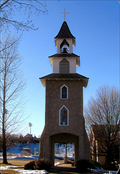
|   St Ignatius Parish Ignacio CO St Ignatius Parish Ignacio CO
in Unique Steeples St Ignatius Parish Ignacio CO has a walk through steeple. posted by:  kingbee kingbee location: Colorado date approved: 03/17/2009 last visited: 03/17/2009 |
 view gallery view gallery NE24.5 km NE24.5 km
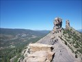
|  Chimney Rock - Archuleta County, CO Chimney Rock - Archuleta County, CO
in American Guide Series This abandoned community can be found in the San Juan National Forest southwest of Pagosa Springs, Colorado. posted by: cldisme location: Colorado date approved: 11/18/2010 last visited: 09/25/2015 |
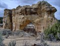
 view gallery view galleryNE24.5 km |  Chimney Rock Archaeological Area - Archuleta County, Colorado Chimney Rock Archaeological Area - Archuleta County, Colorado
in Ghost Towns This abandoned community can be found in the San Juan National Forest southwest of Pagosa Springs, Colorado. posted by: cldisme location: Colorado date approved: 10/05/2010 last visited: 09/25/2015 |
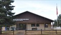 view gallery view galleryNW24.8 km |  Bayfield, Colorado 81122 Bayfield, Colorado 81122
in U.S. Post Offices This Post Office is located at 145 Park Street in Bayfield, Colorado. posted by: brwhiz location: Colorado date approved: 10/31/2011 last visited: 10/01/2019 |
 view gallery view gallery N24.9 km N24.9 km
|  A&W - Bayfield, Colorado A&W - Bayfield, Colorado
in A + W Restaurants This A&W is combined with a gas station. posted by: SageInThyme82 location: Colorado date approved: 09/30/2015 last visited: 10/07/2009 |
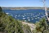 view gallery view gallery SW26.2 km SW26.2 km
|  Navajo Lake State Park - New Mexico Navajo Lake State Park - New Mexico
in State/Provincial Parks A great state park. posted by: kingbee location: New Mexico date approved: 03/17/2009 last visited: 03/17/2009 |
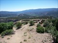
 SW26.6 km |  San Juan Point(Quality Waters) San Juan Point(Quality Waters)
in Fishing Holes Quality waters of the San Juan River posted by: aztecsearcher location: New Mexico date approved: 09/19/2005 last visited: 07/25/2007 |
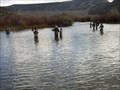 view gallery view gallerySW26.7 km | San Juan River in Fishing Holes One of the best places in the world to Fly Fish. posted by: Team Simber location: New Mexico date approved: 11/15/2005 last visited: 05/06/2008 |
 view gallery view galleryNW27.8 km |  Durango - La Plata County Airport ~ Durango, Colorado Durango - La Plata County Airport ~ Durango, Colorado
in Airports This Airport is located at 1000 Airport Road about 10 miles southeast of downtown Durango, Colorado. posted by: brwhiz location: Colorado date approved: 02/15/2013 last visited: 10/01/2019 |
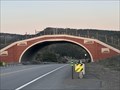 view gallery view galleryNE28.8 km |  US 160 Wildlife Crossing - Near Chimney Rock, CO US 160 Wildlife Crossing - Near Chimney Rock, CO
in Man-made Animal Bridges and Crossings An animal crossings placed in 2021 by CDOT that helps connect portions of the San Juan National Forest bisected by highway US 160. posted by: childofatom location: Colorado date approved: 05/03/2024 last visited: never |
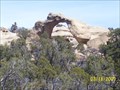
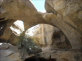 view gallery view gallery W34.6 km W34.6 km
|  Twin Tower Arch Twin Tower Arch
in Natural Arches A nice arch. posted by: kingbee location: New Mexico date approved: 11/15/2011 last visited: 11/15/2011 |
 view gallery view gallerySW35.6 km | Hart Canon Arch in Natural Arches A unique arch by itself. posted by: kingbee location: New Mexico date approved: 03/11/2009 last visited: 11/18/2011 |
 view gallery view galleryW37.7 km | Cedar Hill Arch NM in Natural Arches Cedar Hill Arch NM is worth the hike up there. posted by: kingbee location: New Mexico date approved: 03/20/2009 last visited: 03/20/2009 |
 view gallery view galleryW37.8 km |  Old 550 metal bridge Cedar Hill NM Old 550 metal bridge Cedar Hill NM
in Orphaned Bridges Old 550 metal bridge Cedar Hill NM next to new one. posted by: kingbee location: New Mexico date approved: 03/20/2009 last visited: 03/20/2009 |
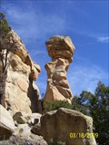 view gallery view galleryW37.8 km |  Cedar Hill balenced rock Cedar Hill balenced rock
in Nature's Balanced Rocks Cedar Hill balenced rock is on the way to the arch. posted by: kingbee location: New Mexico date approved: 03/22/2009 last visited: 10/02/2011 |
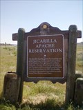 view gallery view gallery SE39.3 km SE39.3 km
|  Jicarilla Apache OSHM Jicarilla Apache OSHM
in New Mexico Historical Markers An OSHM sign in NM posted by: kingbee location: New Mexico date approved: 06/05/2011 last visited: 09/28/2011 |
 view gallery view gallerySW39.8 km |  Aztec NM UFO Crash Site Aztec NM UFO Crash Site
in Weird Story Locations UFO Crash Site? Tell if you see any aliens. posted by: kingbee location: New Mexico date approved: 07/11/2009 last visited: 12/13/2011 |
 view gallery view gallerySW39.8 km |  Alien MTB ride - Aztec New Mexico, UFO Crash site Alien MTB ride - Aztec New Mexico, UFO Crash site
in Mountain Bike Trailheads A good back country bike trail posted by: kingbee location: New Mexico date approved: 03/16/2009 last visited: 03/16/2009 |
 view gallery view galleryNE40.7 km |  Hot Springs Duel - Pagosa Springs, CO Hot Springs Duel - Pagosa Springs, CO
in Signs of History located at a small pull off on Hwy 160 west of Pagosa Springs. posted by: mr.volkswagen location: Colorado date approved: 10/29/2009 last visited: 07/02/2014 |
 view gallery view galleryNE40.7 km |  Col. Albert H. Pfeiffer ~ Pagosa Springs, Colorado Col. Albert H. Pfeiffer ~ Pagosa Springs, Colorado
in Colorado Historical Markers This Colorado Historical Marker is located in a turnout on the northwest side of US Highway 160 on the western edge of Pagosa Springs, Colorado. posted by: brwhiz location: Colorado date approved: 02/14/2013 last visited: 07/02/2014 |
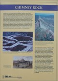 view gallery view galleryNE40.7 km | Chimney Rock - Pagosa Springs, Colorado in Colorado Historical Markers This Colorado Historical Marker is located in a turnout on the northwest side of US Highway 160 on the western edge of Pagosa Springs, Colorado. posted by: brwhiz location: Colorado date approved: 02/22/2013 last visited: 09/13/2014 |
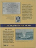 view gallery view galleryNE40.7 km | The Old Spanish Trail - Pagosa Springs, Colorado in Colorado Historical Markers This Colorado Historical Marker is located in a turnout on the northwest side of US Highway 160 on the western edge of Pagosa Springs, Colorado. posted by: brwhiz location: Colorado date approved: 02/25/2013 last visited: 07/02/2014 |
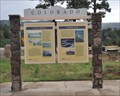 view gallery view galleryNE40.7 km | Pagosa Springs - Pagosa Springs, Colorado in Colorado Historical Markers This Colorado Historical Marker is located in a turnout on the northwest side of US Highway 160 on the western edge of Pagosa Springs, Colorado. posted by: brwhiz location: Colorado date approved: 02/16/2013 last visited: 07/02/2014 |
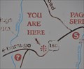
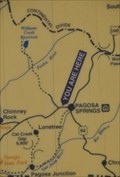 view gallery view galleryNE40.7 km |  Pagosa Springs Historical Marker Pagosa Springs Historical Marker
in 'You Are Here' Maps You Are Here at the Pagosa Springs Historical Marker on US Highway 160 west of Pagosa Springs. posted by: brwhiz location: Colorado date approved: 09/12/2013 last visited: 07/02/2014 |
 view gallery view galleryNE40.7 km | Pagosa Rotary Club Park in 'You Are Here' Maps You Are Here at the Pagosa Rotary Club Park on US Highway 160 west of Pagosa Springs. posted by: brwhiz location: Colorado date approved: 09/12/2013 last visited: 07/02/2014 |
|