 view gallery view gallery N10 km N10 km
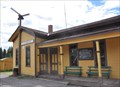
|   Sublette, New Mexico Sublette, New Mexico
in Ghost Towns Sublette, New Mexico is a water stop on the Cumbes and Toltek Train ride. posted by:  GT.US GT.US location: New Mexico date approved: 08/11/2011 last visited: 08/25/2008 |
 view gallery view gallery NW14.5 km NW14.5 km
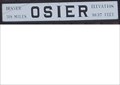
|  9637 feet - Osier, Colorado 9637 feet - Osier, Colorado
in Elevation Signs The Osier train station is at elevation 9637. posted by: GT.US location: Colorado date approved: 08/12/2011 last visited: 08/25/2008 |
 view gallery view gallery NE16.7 km NE16.7 km
|  Railroad Water Tower - Los Pinos, NM Railroad Water Tower - Los Pinos, NM
in Water Towers This water tower was found along the Cumbres & Toltec scenic railroad. posted by: GT.US location: New Mexico date approved: 08/11/2011 last visited: never |
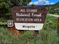 view gallery view galleryN18.7 km |  Mogote Campground - Rio Grande National Forest - Conejos County, CO Mogote Campground - Rio Grande National Forest - Conejos County, CO
in Campgrounds Located in the Rio Grande National Forest just off Colorado highway 17 of approximately 6 miles from Antonito, CO. posted by:  mr.volkswagen mr.volkswagen location: Colorado date approved: 07/25/2022 last visited: never |
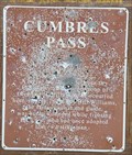
 view gallery view galleryNW21.7 km | Cumbres Pass ~ Elevation 10,022 Feet in Elevation Signs This Elevation Sign is at the summit of Cumbres Pass on Colorado Highway 17 between Antonito, Colorado and Chama, New Mexico. posted by: brwhiz location: Utah date approved: 04/26/2013 last visited: 09/25/2015 |
 view gallery view galleryNW21.7 km | Cumbres Pass ~ Altitude 10,022 Feet in Elevation Signs This Elevation is part of the Historical Marker mounted on a slab of rock on the west side of Colorado Highway 17 at the summit of Cumbres Pass about 4 miles northeast of the Colorado/New Mexico border. posted by: brwhiz location: Colorado date approved: 03/11/2013 last visited: 09/25/2015 |
 view gallery view galleryNW21.7 km |  Cumbres Pass - Conejo County, Colorado Cumbres Pass - Conejo County, Colorado
in Colorado Historical Markers This Colorado Historical Marker is mounted on a slab of rock on the west side of Colorado Highway 17 at the summit of Cumbres Pass about 4 miles north northeast of the Colorado/New Mexico border. posted by: brwhiz location: Colorado date approved: 03/11/2013 last visited: 09/24/2015 |
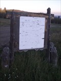
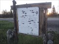
 view gallery view galleryNW21.7 km |  Cumbres Pass Summit Information Kiosk Cumbres Pass Summit Information Kiosk
in 'You Are Here' Maps You Are Here at the Cumbres Pass Summit Information Kiosk on the west side of Colorado Highway just south of the narrow guage tracks east of the Cumbres pass Train Station of the Cumbres & Toltec Narrow Guage Scenic Railroad. posted by: brwhiz location: Colorado date approved: 08/29/2013 last visited: never |
 view gallery view galleryNW21.7 km |  Cumbres Station Cumbres Station
in Active Rail Locations Cubres Station, just west of Colorado Highway 17 at the summit of Cumbres Pass, is a great place to witness narrow guage steam power twice a day during the tourist season. posted by: brwhiz location: Colorado date approved: 03/11/2013 last visited: never |
 view gallery view galleryNW21.9 km | Cumbres Station ~ Elevation 10015 Feet in Elevation Signs This Elevation Sign is mounted on the end of the Cumbres Train Station at the summit of Cumbres Pass southwest of Antonito, Colorado. posted by: brwhiz location: Colorado date approved: 05/06/2013 last visited: never |
 view gallery view galleryNW21.9 km |  Cumbres Station Cumbres Station
in Train Stations/Depots This Train Station is located on the west side of Colorado Highway 17 at the summit of Cumbres Pass about 4 miles northeast of the Colorado/New Mexico border. posted by: brwhiz location: Colorado date approved: 03/11/2013 last visited: 09/24/2015 |
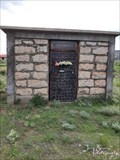
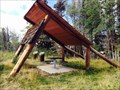 view gallery view gallery SW21.9 km SW21.9 km
|  Orlando Memorial - New Mexico Orlando Memorial - New Mexico
in Out of Place Graves We were on our fall hiking vacation and stopped at this small rest area to stretch our legs when we saw a small trail behind this covered table. Wondering whats behind here, we were surprised to find a secluded marker. posted by: 2Muskadeers location: New Mexico date approved: 04/09/2016 last visited: never |
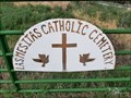 view gallery view galleryNE22.2 km |  Las Mesitas Catholic Cemetery - Las Mesitas, CO Las Mesitas Catholic Cemetery - Las Mesitas, CO
in Worldwide Cemeteries Located just off Colorado Highway 16, just 6 miles west of Antonito, CO. posted by: mr.volkswagen location: Colorado date approved: 07/21/2022 last visited: never |
 view gallery view galleryNE22.2 km | Keeping The Faith - Las Mesitas, CO in Colorado Historical Markers The historical plaque is on the inside of the fence. You are able to cross fence as it also goes to the Las Mesitas Catholic Cemetery. posted by: mr.volkswagen location: Colorado date approved: 07/20/2022 last visited: never |
 view gallery view galleryNE22.2 km |  Jaramilo Masoleum - Las Mesitas Catholic Cemetery - Las Mesitas, CO Jaramilo Masoleum - Las Mesitas Catholic Cemetery - Las Mesitas, CO
in Mausoleums Located at the west end of the Las Mesitas Catholic Cemetery. posted by: mr.volkswagen location: Colorado date approved: 08/05/2022 last visited: never |
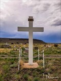 view gallery view galleryNE22.4 km |  Las Mesitas Catholic Cemetery Cross - Las Masitas, CO Las Mesitas Catholic Cemetery Cross - Las Masitas, CO
in Churchyard Crosses This cross is located in the Las Mesitas Catholic cemetery in Las Mesitas, CO. posted by: mr.volkswagen location: Colorado date approved: 07/25/2022 last visited: never |
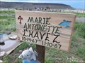 view gallery view galleryNE22.4 km |  Marie Antonette Chavez - Las Mesitas, CO Marie Antonette Chavez - Las Mesitas, CO
in Homemade Tombstones Located in the Las Mesitas Catholic Cemetery. Cemetery is behind the San Isidro Church. posted by: mr.volkswagen location: Colorado date approved: 07/22/2022 last visited: never |
 view gallery view galleryNW23 km | La Manga Pass ~ Elevation 10,230 Feet in Elevation Signs This Elevation Sign is at the summit of La Manga Pass on Colorado Highway 17 between Antonito, Colorado and Chama, New Mexico. posted by: brwhiz location: Colorado date approved: 04/26/2013 last visited: never |
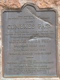
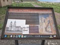
 view gallery view galleryNW24.1 km |  Cumbres Pass Cumbres Pass
in New Mexico Historical Markers This badly damaged New Mexico Official Scenic Historic Marker is located at a turnout at the Colorado/New Mexico border. The reverse side shows the location of other similar markers in the general area. posted by: brwhiz location: New Mexico date approved: 11/05/2012 last visited: 05/29/2014 |
 view gallery view galleryNW24.1 km |  CO/NM Border on CO 17/NM/17 CO/NM Border on CO 17/NM/17
in Border Crossings As you travel the southern slope of Cumbres Pass you cross the border between Colorado and New Mexico. Only a change in the pavement marks the actual border. posted by: brwhiz location: New Mexico date approved: 11/19/2012 last visited: 05/29/2014 |
 view gallery view galleryNW24.3 km |  Welcome to New Mexico - Land of Enchantment Welcome to New Mexico - Land of Enchantment
in Welcome Signs This Welcome Sign sits (leans) on the east side of New Mexico Highway 17 as you descend the southern slope of Cumbres Pass and shortly after you cross over the border from Colorado. posted by: brwhiz location: New Mexico date approved: 11/18/2012 last visited: 05/29/2014 |
 view gallery view galleryNW24.3 km | Welcome to New Mexico ~ The Land of Enchantment in Welcome Signs This Welcome Sign is on the west side of New Mexico Highway 17 as you descend the southern slope of Cumbres Pass and shortly after you cross over the border from Colorado. posted by: brwhiz location: New Mexico date approved: 02/06/2013 last visited: 05/29/2014 |
 view gallery view gallerySW24.5 km | Brazos Cliffs - Crowther Cow Camp, NM in New Mexico Historical Markers This marker is at a small pullof off of Route 64 with a nice view of the cliffs. posted by: GT.US location: New Mexico date approved: 08/11/2011 last visited: 07/22/2011 |
 view gallery view gallerySW24.5 km | You-Are-Here in Brazos Cliffs, NM in 'You Are Here' Maps This 'You are Here' sign is on the back of a New Mexico Historical Marker for the Brazos Cliffs. posted by: GT.US location: New Mexico date approved: 08/12/2011 last visited: 07/22/2011 |
 view gallery view gallery W28 km W28 km
| Chama, New Mexico ~ Elevation 7860 Feet in Elevation Signs This combination Elevation/Population sign is at the northern village limits of Chama, New Mexico on New Mexico Highway 17. posted by: brwhiz location: New Mexico date approved: 09/07/2012 last visited: never |
|