 view gallery view gallery SW13 km SW13 km
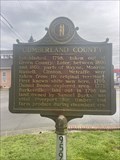
|   Cumberland County #959 - Burkesville KY Cumberland County #959 - Burkesville KY
in Kentucky Historical Markers Cumberland County #959 located in the Cumberland County Courthouse square in Burkesville, KY. posted by:  Team Geologynut Team Geologynut location: Kentucky date approved: 04/08/2023 last visited: never |
 view gallery view gallerySW13 km | Morgan ~ On To Ohio #515 - Burkesville KY in Kentucky Historical Markers Morgan ~ On To Ohio #515 located in the Cumberland County Courthouse square in Burkesville, KY. posted by: Team Geologynut location: Kentucky date approved: 04/08/2023 last visited: never |
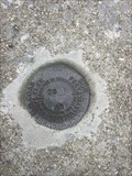
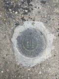
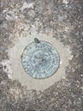
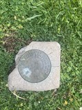 view gallery view gallerySW13 km |  S 43 (GB1332) - Burkesville, KY S 43 (GB1332) - Burkesville, KY
in U.S. Benchmarks A USC&G benchmark disk on the grounds of the old Cumberland County Courthouse. posted by: Team Geologynut location: Kentucky date approved: 04/10/2023 last visited: never |
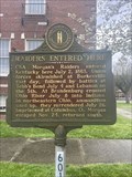 view gallery view gallerySW13 km | Raiders Entered Here #601 - Burkesville KY in Kentucky Historical Markers Raiders Entered Here #601 located in the Cumberland County Courthouse square in Burkesville, KY. posted by: Team Geologynut location: Kentucky date approved: 04/07/2023 last visited: never |
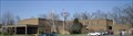
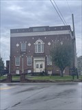 view gallery view gallerySW13 km |  Cumberland County Courthouse - Burkesville, KY Cumberland County Courthouse - Burkesville, KY
in Courthouses Cumberland County Courthouse located in the middle of Burkesville Kentucky. posted by: Team Geologynut location: Kentucky date approved: 04/07/2023 last visited: never |
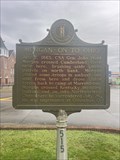
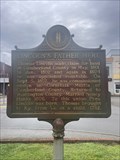 view gallery view gallerySW13 km | Lincoln's Father Here #885 - Burkesville KY in Kentucky Historical Markers Lincoln's Father Here #885 located in the Cumberland County Courthouse square in Burkesville, KY. posted by: Team Geologynut location: Kentucky date approved: 04/08/2023 last visited: never |
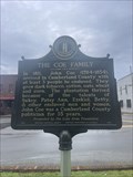 view gallery view gallerySW13 km | The Coe Family #2614 - Burkesville KY in Kentucky Historical Markers The Coe Family #2614 located in the Cumberland County Courthouse square in Burkesville, KY. posted by: Team Geologynut location: Kentucky date approved: 04/08/2023 last visited: never |
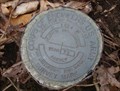
 view gallery view gallerySW14.5 km | C 251 (GB1342) - Burkesville, Cumberland County KY in U.S. Benchmarks An easy to find USC&G benchmark on a bridge abutment on Glasgow Rd (Hwy 90) NW of Burkesville KY. I parked 175ft west where the shoulder was wide. posted by: Team Geologynut location: Kentucky date approved: 04/10/2023 last visited: never |
 view gallery view gallerySW17.7 km | H 251 (GB1346) - Burkesville, Cumberland County KY in U.S. Benchmarks An easy to find USC&G benchmark on a bridge abutment on Glasgow Rd (Hwy 90) NW of Burkesville KY. I parked across the street at a large parking lot. posted by: Team Geologynut location: Kentucky date approved: 04/10/2023 last visited: never |
 view gallery view gallerySW18.3 km | N 252 (GB1536) - Cumberland County, KY in U.S. Benchmarks A USC&G benchmark on a culvert headwall on Mud Camp Rd. (state hwy 100). Pull off right next to it. posted by: Team Geologynut location: Kentucky date approved: 04/10/2023 last visited: never |
 view gallery view gallery E19.8 km E19.8 km
| Barstehunbre's Pumpkin Creek Survey Disk in U.S. Benchmarks This is a U.S. Army Corp of Engineers survey disk marker posted by: barstehunbre location: Kentucky date approved: 03/21/2010 last visited: never |
 view gallery view gallery N22.4 km N22.4 km
|  Westlake Regional Hospital, Columbia, Kentucky Westlake Regional Hospital, Columbia, Kentucky
in Hospitals Westlake Regional Hospital is a non-profit facility that provides medical services to the citizens in the Columbia, Kentucky region and is a critical access hospital. posted by: PersonsMD location: Kentucky date approved: 03/20/2010 last visited: 03/18/2010 |
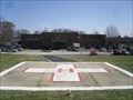 view gallery view galleryN22.4 km |  Westlake Regional Hospital Landing Pad, Columbia, Kentucky Westlake Regional Hospital Landing Pad, Columbia, Kentucky
in Helicopter Landing Pads Located at the Westlake Regional Hospital in Columbia, Kentucky, this landing pad provides emergency transport and first responder services for the citizens of the region. posted by: PersonsMD location: Kentucky date approved: 03/19/2010 last visited: 03/18/2010 |
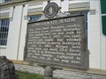
 view gallery view galleryN22.9 km | Adair County Courthouse - Columbia, KY in Kentucky Historical Markers A Kentucky historical marker on the south lawn of the Adair County Courthouse describing that building. posted by: ggmorton location: Kentucky date approved: 04/20/2024 last visited: never |
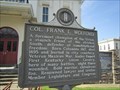 view gallery view galleryN22.9 km | Col. Frank L. Wolford - Columbia, KY in Kentucky Historical Markers A Kentucky historical marker on the south lawn of the Adair County Courthouse describing a renowned local warrior and legislator. posted by: ggmorton location: Kentucky date approved: 04/20/2024 last visited: never |
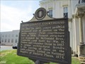
 view gallery view galleryN22.9 km | Confederate Raids - Columbia, KY in Kentucky Historical Markers A Kentucky historical marker located on the southwestern courthouse lawn in Columbia, KY about Civil War troop movements. posted by: ggmorton location: Kentucky date approved: 04/22/2024 last visited: never |
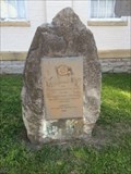
 view gallery view galleryN22.9 km |  Adair County Revolutionary War Memorial - Columbia, KY, USA Adair County Revolutionary War Memorial - Columbia, KY, USA
in Daughters of the American Revolution Marker is in Columbia, Kentucky, in Adair County. Memorial is at the intersection of Public Square and Burkesville Street. Marker is a limestone boulder with bronze plaque attached. DAR insignia is in top center of plaque. posted by: Crazy4horses location: Kentucky date approved: 05/27/2023 last visited: 04/16/2024 |
 view gallery view galleryN22.9 km |  Adair County Revolutionary War Memorial - Columbia, KY Adair County Revolutionary War Memorial - Columbia, KY
in U.S. Revolutionary War Memorials Marker is in Columbia, Kentucky, in Adair County. Memorial is at the intersection of Public Square and Burkesville Street (Kentucky Route 80), on the left when traveling south on Public Square. posted by: Crazy4horses location: Kentucky date approved: 04/17/2023 last visited: 04/16/2024 |
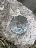
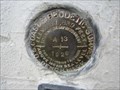 view gallery view galleryN22.9 km | A 13 (GZ1479) - Columbia, KY in U.S. Benchmarks A benchmark located on the SE corner of the Adair County, Kentucky courthouse. posted by: ggmorton location: Kentucky date approved: 04/19/2024 last visited: never |
 view gallery view galleryN22.9 km |  Adair County Courthouse Clock - Columbia, KY Adair County Courthouse Clock - Columbia, KY
in Town Clocks The town clock on the clock tower of the Adair County, Kentucky courthouse in Columbia, Kentucky. posted by: ggmorton location: Kentucky date approved: 04/19/2024 last visited: never |
 view gallery view galleryN23 km | Adair County Courthouse - Columbia, KY in Courthouses The historic Adair County, Kentucky courthouse in Columbia, Kentucky. posted by: ggmorton location: Kentucky date approved: 04/19/2024 last visited: never |
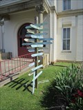 view gallery view galleryN23 km |  Adair County Courthouse - Columbia, KY Adair County Courthouse - Columbia, KY
in Direction and Distance Arrows A set of direction and distance arrow signs is located on the north (west) side of the historic Adair County, Kentucky courthouse in Columbia, Kentucky. posted by: ggmorton location: Kentucky date approved: 05/03/2024 last visited: never |
 view gallery view galleryN23 km |  Lindsey Wilson College - Columbia, Kentucky Lindsey Wilson College - Columbia, Kentucky
in Universities and Colleges Classified by the Carnegie Foundation for the Advancement of Teaching as a Baccalaureate Liberal Arts College, Lindsey Wilson College is located in Columbia, Kentucky on more than 200 acres in South Central Kentucky. posted by: PersonsMD location: Kentucky date approved: 04/17/2010 last visited: 03/18/2010 |
 view gallery view gallerySW24.9 km | R 252 (GB2151) - Cumberland County, KY in U.S. Benchmarks A USC&G benchmark on a bridge abutment on Mud Camp Rd. (state hwy 100). posted by: Team Geologynut location: Kentucky date approved: 04/10/2023 last visited: never |
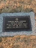 view gallery view gallery SE27.2 km SE27.2 km
|  Garlin Murl Conner-Albany, KY Garlin Murl Conner-Albany, KY
in Medal Of Honor Resting Places World War II Medal of Honor Recipient for action at Houssen, France on January 24, 1945. He was awarded the Medal of Honor on June 26, 2018. He is buried in Memorial Hill Cemetery, Albany, KY. posted by:  Don.Morfe Don.Morfe location: Kentucky date approved: 12/21/2018 last visited: 12/07/2021 |
|