 view gallery view gallery S5.8 km S5.8 km
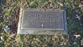
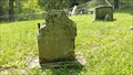
|   Henry Dickenson ~ Old Russell County Courthouse Cemetery ~ Dickensonville, Virginia. Henry Dickenson ~ Old Russell County Courthouse Cemetery ~ Dickensonville, Virginia.
in American Revolutionary War Veteran Graves Grave of Henry Dickenson, an American Revolutionary War Soilder. posted by:  Manville Possum Manville Possum location: Virginia date approved: 04/15/2014 last visited: 12/30/2019 |
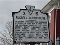
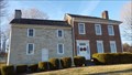 view gallery view galleryS5.8 km |  Old Russell County Courthouse Old Russell County Courthouse
in U.S. National Register of Historic Places The Old Russell County Courthouse. posted by: Manville Possum location: Virginia date approved: 04/13/2014 last visited: 12/30/2019 |
 view gallery view galleryS5.8 km |  LOVEwork in Russell County ~ Castlewood, Virginia - USA. LOVEwork in Russell County ~ Castlewood, Virginia - USA.
in Silhouette Public Art Sculptures Located on the grounds of the historic Old Russell County Courthouse and Dickenson Bundy Log House, this LOVEwork was created with great pride by the 2016-2017 welding class of the Russell County Career and Technical Center. posted by: Manville Possum location: Virginia date approved: 01/16/2020 last visited: 01/16/2020 |
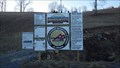
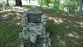
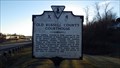 view gallery view galleryS5.8 km |  Old Russell County Courthouse Old Russell County Courthouse
in Virginia Historical Markers A Virginia Historical Marker placed in 1986 by the Department of Conservation and Historic Resources. posted by: Manville Possum location: Virginia date approved: 02/22/2014 last visited: 12/30/2019 |
 view gallery view gallery W6.4 km W6.4 km
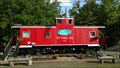
|  Caboose ~ St Paul, Virginia. Caboose ~ St Paul, Virginia.
in Train Cabooses Caboose used as rafting adventure business in St Paul, Virginia. posted by: Manville Possum location: Virginia date approved: 06/09/2017 last visited: 12/30/2019 |
 view gallery view galleryW7.1 km |  Spearhead Trails ~ Mountian View ~ St. Paul, VA. Spearhead Trails ~ Mountian View ~ St. Paul, VA.
in Offroad Trails Spearhead Trails is the exciting new trail destination in Southwest Virginia. posted by: Manville Possum location: Virginia date approved: 03/13/2014 last visited: 12/30/2019 |
 view gallery view galleryW7.4 km | Wise County/Russell County in Virginia Historical Markers A Virginia Historical Marker placed in 2003 by the Department of Historic Resources. posted by: Manville Possum location: Virginia date approved: 06/20/2016 last visited: 12/30/2019 |
 view gallery view gallery SW8 km SW8 km
| Moore's Fort ~ Russell County, Virginia in Virginia Historical Markers A Virginia Historical Marker placed by the Department of Historic Resources in 2003. posted by: Manville Possum location: Virginia date approved: 06/02/2018 last visited: 06/02/2018 |
 view gallery view gallerySW9.8 km | Dorton's Fort in Virginia Historical Markers A Virginia Historical Marker placed by the Department of Historic Resources in 2004. posted by: Manville Possum location: Virginia date approved: 02/23/2014 last visited: 12/30/2019 |
 view gallery view galleryW10.1 km |  Virginia City Presbyterian Church. Virginia City, Virginia Virginia City Presbyterian Church. Virginia City, Virginia
in This Old Church The Virginia City Church, erected c.1895 by coal camp residents on land donated by the Russell Creek Coal Company, is the only surviving structure from the once bustling mining community of Virginia City. The structure also served as the first schoolhouse for Virginia City. Although maintained by the Presbyterian Church, anyone was welcomed to preach in the church, and so it was used by many different denominations. posted by: UberHOKIE location: Virginia date approved: 12/28/2008 last visited: 12/25/2009 |
 view gallery view galleryW10.1 km | Virginia City Presbyterian Church- Virginia City, Virginia in Country Churches The Virginia City Church, erected c.1895 by coal camp residents on land donated by the Russell Creek Coal Company, is the only surviving structure from the once bustling mining community of Virginia City. The structure also served as the first schoolhouse for Virginia City. Although maintained by the Presbyterian Church, anyone was welcomed to preach in the church, and so it was used by many different denominations. posted by: UberHOKIE location: Virginia date approved: 12/29/2008 last visited: never |
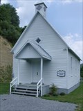 view gallery view galleryW10.1 km | Virginia City Presbyterian Church - Castlewood, Virginia in U.S. National Register of Historic Places The Virginia City Church, erected c.1895 by coal camp residents on land donated by the Russell Creek Coal Company, is the only surviving structure from the once bustling mining community of Virginia City. The structure also served as the first schoolhouse for Virginia City. Although maintained by the Presbyterian Church, anyone was welcomed to preach in the church, and so it was used by many different denominations.
posted by: UberHOKIE location: Virginia date approved: 12/28/2008 last visited: never |
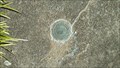 view gallery view gallery E14 km E14 km
|  GA0354 ~ Lebanon, Virginia. GA0354 ~ Lebanon, Virginia.
in U.S. Benchmarks A 1963 U.S. Coast & Geodetic Survey azimuth disk. posted by: Manville Possum location: Virginia date approved: 11/03/2016 last visited: 12/30/2019 |
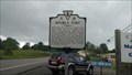
 view gallery view galleryE14.2 km | Russell Courthouse in Virginia Historical Markers This historic marker stands on the grounds of the Russell County Courthouse in Lebanon, Virginia posted by:  Sneakin Deacon Sneakin Deacon location: Virginia date approved: 11/19/2008 last visited: 10/29/2016 |
 view gallery view galleryE14.2 km |  Russell County Courthouse - Lebanon, Virginia Russell County Courthouse - Lebanon, Virginia
in Courthouses The Russell County Courthouse stands on Main Street in Lebanon, Virginia. posted by: Sneakin Deacon location: Virginia date approved: 11/20/2008 last visited: 10/29/2016 |
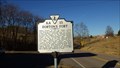
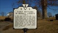 view gallery view gallerySW15.1 km | Early Settlers in Russell County in Virginia Historical Markers A Virginia Historical Marker erected in 1982. posted by: Manville Possum location: Virginia date approved: 04/01/2014 last visited: 12/30/2019 |
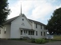 view gallery view galleryE17.5 km |  Oak Grove Baptist Church - Lebanon, VA Oak Grove Baptist Church - Lebanon, VA
in Baptist Churches A white Baptist church out in the Virginia country posted by: vhasler location: Virginia date approved: 08/21/2010 last visited: never |
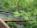 view gallery view gallery NE17.7 km NE17.7 km
|  Swinging Bridge at Pinnacle Natural Area Preserve, VA Swinging Bridge at Pinnacle Natural Area Preserve, VA
in Pedestrian Suspension Bridges A sturdy suspension bridge over the Big Cedar Creek posted by: vhasler location: Virginia date approved: 08/15/2010 last visited: never |
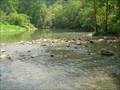
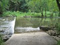 view gallery view galleryNE17.9 km |  Ford of Big Cedar Creek in Pinnacle Natural Area Preserve, VA Ford of Big Cedar Creek in Pinnacle Natural Area Preserve, VA
in Bridgeless Water Crossings The park road fords through the Big Cedar Creek posted by: vhasler location: Virginia date approved: 08/28/2010 last visited: never |
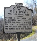 view gallery view galleryW17.9 km | Scott / Wise County in Virginia Historical Markers County line marker gives bit of history about both. Wise named after VA govenor and Scott after army commander. posted by: vhasler location: Virginia date approved: 02/09/2012 last visited: 04/13/2014 |
 view gallery view galleryW18 km | Spearhead Trails Coeburn Connector ~ Coeburn, Virginia in Offroad Trails The Coeburn connector trail to Spearhead's Mountain View Trail system in St. Paul. posted by: Manville Possum location: Virginia date approved: 06/05/2017 last visited: 12/30/2019 |
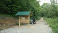 view gallery view galleryW18 km |  Spearhead Trails Mountain View Kiosk ~ Coeburn, Virginia Spearhead Trails Mountain View Kiosk ~ Coeburn, Virginia
in Eagle Scout Project Sites Spearhead Trails Mountain View trailhead kiosk was donated and constructed by Eagle Scout Dominic Sluss of Coeburn troop 301. posted by: Manville Possum location: Virginia date approved: 06/05/2017 last visited: 12/30/2019 |
 view gallery view galleryNE18.5 km |  CONFLUENCE - Big Cedar Creek and Clinch River, VA CONFLUENCE - Big Cedar Creek and Clinch River, VA
in River Origins, Destinations and Confluences The Clinch River flows down from Tazewell, VA to the Tennessee border. At this point, the Big Cedar Creek flowing from SE of Lebanon, VA joins into the Clinch River. posted by: vhasler location: Virginia date approved: 08/21/2010 last visited: never |
 view gallery view galleryS18.7 km |  Frank Rose ~ Hampton Cemetery ~ Mendota, VA. Frank Rose ~ Hampton Cemetery ~ Mendota, VA.
in Homemade Tombstones A homemade headstone for Frank Rose in Hampton Cemetery, Mendota, Virginia. posted by: Manville Possum location: Virginia date approved: 05/19/2016 last visited: 12/30/2019 |
 view gallery view galleryS18.7 km | OS and Kate Anderson ~ Hampton Cemetery ~ Mendota, VA. in Homemade Tombstones A homemade headstone for OS and Kate Anderson in Hampton Cemetery, Mendota, Virginia. posted by: Manville Possum location: Virginia date approved: 05/19/2016 last visited: 12/30/2019 |
|