 view gallery view gallery NW0 km NW0 km
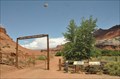
|   Lonely Dell Ranch Entrance Lonely Dell Ranch Entrance
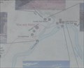
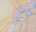
in 'You Are Here' Maps You Are Here at the entrance to the Lonely Dell Ranch Historic District near Lee's Ferry, just north of Lee's Ferry Road about 4.5 miles from US Highway 89A at Marble Canyon, Arizona. posted by:  brwhiz brwhiz location: Arizona date approved: 11/21/2012 last visited: never |
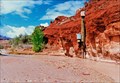
 view gallery view galleryNW0 km |  Lonely Dell Ranch Self-Guided Walking Tour Lonely Dell Ranch Self-Guided Walking Tour
in Self Guided Walks and Trails This self-guided tour follows a one mile (round-trip) trail through the Lonely Dell Ranch National Historic District about 0.4 miles north of Lee's Ferry Road and about 5.6 miles from Marble, Canyon, Arizona. posted by: brwhiz location: Arizona date approved: 12/01/2012 last visited: never |
 view gallery view gallery NE0.5 km NE0.5 km
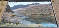
|  DOIGS Paria River Gaging Station DOIGS Paria River Gaging Station
in River Gauges A DOIGS Paria River Gaging Station benchmark and gaging station posted by:  tincanbits tincanbits location: Arizona date approved: 08/24/2013 last visited: never |
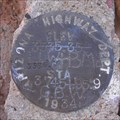
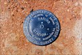 view gallery view galleryNE0.5 km |  USDOIGS Gaging Station USDOIGS Gaging Station
in U.S. Benchmarks USDOIGS Gaging Station Benchmark or disk posted by: tincanbits location: Arizona date approved: 08/24/2013 last visited: never |
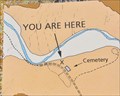 view gallery view galleryNW0.6 km | Lonely Dell Ranch Cemetery in 'You Are Here' Maps You Are Here at the Cemetery on the upper end of the Lonely Dell Ranch Historic District near Lee's Ferry, just north of Lee's Ferry Road about 4.5 miles from US Highway 89A at Marble Canyon, Arizona. posted by: brwhiz location: Arizona date approved: 11/21/2012 last visited: never |
 view gallery view gallery SW0.8 km SW0.8 km
| Lee's Ferry Ranger Station #1 in 'You Are Here' Maps You Are Here at the Lee's Ferry Ranger Station for the Glen Canyon National Recreation Area on Lee's Ferry Road about 4.7 miles from US Highway 89A at Marble Canyon, Arizona. posted by: brwhiz location: Arizona date approved: 11/21/2012 last visited: never |
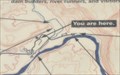 view gallery view gallerySW0.8 km | Lee's Ferry Ranger Station #2 in 'You Are Here' Maps You Are Here at the Lee's Ferry Ranger Station for the Glen Canyon National Recreation Area on Lee's Ferry Road about 4.7 miles from US Highway 89A at Marble Canyon, Arizona. posted by: brwhiz location: Arizona date approved: 11/21/2012 last visited: never |
 view gallery view gallery E0.8 km E0.8 km
| Lee's Ferry on the Colorado River in Self Guided Walks and Trails This self-guided tour follows a 3/4 mile (one-way) trail through the Lee's Ferry National Historic District at the northeast end of Lee's Ferry Road about 6 miles from Marble, Canyon, Arizona. posted by: brwhiz location: Arizona date approved: 12/01/2012 last visited: never |
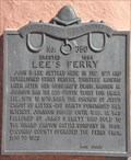 view gallery view galleryE0.8 km |  Lee's Ferry ~ 350 Lee's Ferry ~ 350
in D.U.P. Historic Markers This Daughters of Utah Pioneers Historical Marker is mounted on a large rock slab near the ruins of the old fort at the northeast end of Lee's Ferry Road, about 6 miles from US Highway 89A at Marble Canyon, Arizona. posted by: brwhiz location: Arizona date approved: 11/22/2012 last visited: never |
 view gallery view galleryE0.8 km |  Lee's Ferry Lee's Ferry
in Arizona Historical Markers This Daughters of Utah Pioneers Historical Marker is mounted on a large rock slab near the ruins of the old fort at the northeast end of Lee's Ferry Road, about 6 miles from US Highway 89A at Marble Canyon, Arizona. posted by: brwhiz location: Arizona date approved: 11/24/2012 last visited: never |
 view gallery view gallerySW1.1 km |  CONFLUENCE - Paria River - Colorado River CONFLUENCE - Paria River - Colorado River
in River Origins, Destinations and Confluences A river confluence in Glen Canyon National Recreation Area. posted by: ggmorton location: Arizona date approved: 10/13/2007 last visited: 11/11/2023 |
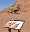
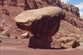 view gallery view gallerySW4.3 km |  Glen Canyon NRA Balanced Rock Glen Canyon NRA Balanced Rock
in Nature's Balanced Rocks A balanced rock on the south western side of the Glen Canyon National Recreation Area. posted by: ggmorton location: Arizona date approved: 10/03/2007 last visited: 08/01/2014 |
 view gallery view gallerySW4.3 km | Lee's Ferry Recreation Area Balanced Rock in Nature's Balanced Rocks This is one of two balanced rocks in the Lee's Ferry area of Glen Canyon National Recreation Area about 2.2 miles northeast of Marble Canyon, Arizona. posted by: brwhiz location: Arizona date approved: 12/10/2012 last visited: 08/01/2014 |
 view gallery view gallerySW6.4 km | USGS Navajo Bridge in U.S. Benchmarks USGS Benchmark on the north side of the eastern embankment of the old Navajo Bridge. posted by: DosHermanas location: Arizona date approved: 09/18/2011 last visited: 10/12/2020 |
 view gallery view gallerySW6.4 km | Navajo Bridge benchmark in U.S. Benchmarks Arizona Highway Dept. benchmark on the north side of the eastern embankment of the old Navajo Bridge. posted by: DosHermanas location: Arizona date approved: 09/18/2011 last visited: 08/01/2014 |
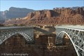
 view gallery view gallerySW6.4 km |  Historic Navajo Bridge Historic Navajo Bridge
in Arch Bridges An old bridge over the Grand Canyon that is now only used for pedestrian traffic. A new bridge for cars was built just to the south. posted by: ggmorton location: Arizona date approved: 10/31/2007 last visited: 07/10/2023 |
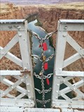 view gallery view gallerySW6.4 km |  Navajo Bridge - AZ, USA Navajo Bridge - AZ, USA
in Love Padlocks Navajo Bridge - AZ, USA posted by: luzzi-reloaded location: Arizona date approved: 11/13/2017 last visited: 10/12/2020 |
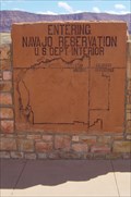 view gallery view gallerySW6.4 km |  Navajo Reservation - Marble Canyon, Arizona, USA Navajo Reservation - Marble Canyon, Arizona, USA
in Nations Within Nations The entrance to the Navajo Indian Reservation at the Navajo Bridge in northern Arizona. posted by: ggmorton location: Arizona date approved: 10/03/2007 last visited: 07/10/2023 |
 view gallery view gallerySW6.4 km |  Navajo Steel Arch Highway Bridge Navajo Steel Arch Highway Bridge
in U.S. National Register of Historic Places A historic vehicular arch bridge that is now only used for pedestrian traffic. posted by: ggmorton location: Arizona date approved: 11/05/2007 last visited: 07/10/2023 |
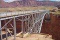 view gallery view gallerySW6.4 km |  Navajo Bridge Navajo Bridge
in Engineering Landmarks A bridge over a portion of the Grand Canyon. posted by: ggmorton location: Arizona date approved: 10/13/2007 last visited: 07/10/2023 |
 view gallery view gallerySW6.4 km |  Navajo Bridge - Arizona, USA Navajo Bridge - Arizona, USA
in Orphaned Bridges The old Navajo Bridge over the Grand Canyon is no longer used for vehicle traffic. posted by: ggmorton location: Arizona date approved: 07/02/2008 last visited: 07/10/2023 |
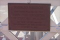
 view gallery view gallerySW6.4 km |  Navajo Bridge - AZ American Guide - Marble Canyon, AZ Navajo Bridge - AZ American Guide - Marble Canyon, AZ
in American Guide Series Navajo Bridge was an engineering accomplishment when completed in 1929 and has been a big tourist spot ever since. Since then, a second bridge was built to withstand today's traffic, the old bridge closed to vehicles, and a new NPS Visitor's Center. posted by: DopeyDuck location: Arizona date approved: 04/10/2009 last visited: 12/02/2023 |
 view gallery view gallerySW6.4 km | Navajo Bridge Interpretive Center in 'You Are Here' Maps You Are Here at the Navajo Bridge Interpretive Center on the west end of the historic Navajo Bridge on US Highway 89A about 1/4 mile northeast of Marble Canyon, Arizona. posted by: brwhiz location: Arizona date approved: 11/21/2012 last visited: 08/01/2014 |
 view gallery view gallerySW6.4 km | Navajo Bridge in 'You Are Here' Maps You Are Here at the west end of the historic Navajo Bridge on US Highway 89A about 1/4 mile northeast of Marble Canyon, Arizona. posted by: brwhiz location: Arizona date approved: 11/21/2012 last visited: 08/24/2014 |
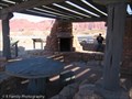 view gallery view gallerySW6.4 km |  Wayside Observation Shelter - Marble Canyon, AZ Wayside Observation Shelter - Marble Canyon, AZ
in Civilian Conservation Corps The Wayside Observation Shelter overlooking Marble Canyon and the Navajo Bridge was built by the CCC between 1938 and 1941. posted by: DopeyDuck location: Arizona date approved: 01/19/2009 last visited: 07/10/2023 |
|