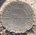
 view gallery view gallery N2.7 km N2.7 km
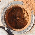
|   USCGS GQ0206 G 499 ~ Littlefield, Arizona USCGS GQ0206 G 499 ~ Littlefield, Arizona
in U.S. Benchmarks This Vertical Control Survey Mark is just south of Interstate 15 Exit 8 at Littlefield, Arizona. posted by:  brwhiz brwhiz location: Arizona date approved: 03/16/2012 last visited: 05/01/2014 |
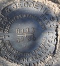 view gallery view gallery W2.7 km W2.7 km
| USCGS GQ0146 ~ H111 Littlefield, Arizona in U.S. Benchmarks This Benchmark is easily spotted on the south side of Old US Highway 91 between Littlefield and Mesquite. posted by: brwhiz location: Arizona date approved: 03/25/2012 last visited: never |
 view gallery view galleryN3.5 km |  The Old Spanish Trail 1829 - 1848 - Beaver Dam, Arizona The Old Spanish Trail 1829 - 1848 - Beaver Dam, Arizona
in Wagon Roads and Trails Historical marker giving a brief history of an early trail through the area.
posted by:  BruceS BruceS location: Arizona date approved: 10/05/2008 last visited: 05/09/2014 |
 view gallery view galleryN3.5 km |  The Old Spanish Trail 1829 - 1848 The Old Spanish Trail 1829 - 1848
in Arizona Historical Markers Historical marker giving a brief history of an early trail through the area. posted by: BruceS location: Arizona date approved: 10/05/2008 last visited: 11/13/2013 |
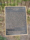 view gallery view galleryN3.5 km |  The Old Spanish Trail 1829 - 1848 The Old Spanish Trail 1829 - 1848
in E Clampus Vitus Historical Markers Historical marker giving a brief history of an early trail through the area. posted by: BruceS location: Arizona date approved: 10/06/2008 last visited: 11/13/2013 |
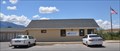
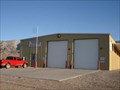 view gallery view gallery NE4.2 km NE4.2 km
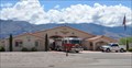
|  Beaver Dam Littlefield Fire District Station No. 1 Beaver Dam Littlefield Fire District Station No. 1
in Firehouses A small plain fire station, this is one of two that serve the 150 square mile area around Beaver Dam, AZ. posted by: frivlas location: Arizona date approved: 01/14/2008 last visited: 01/31/2012 |
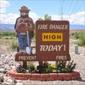 view gallery view galleryN4.5 km |  Smokey at Beaver Dam/Littlefield Firestation Number 1 ~ Beaver Dam, Arizona Smokey at Beaver Dam/Littlefield Firestation Number 1 ~ Beaver Dam, Arizona
in Smokey Bear Sign Sightings This Smokey stands watch on Old US Highway 91 (now Arizona Highway 91) next to Beaver Dam/Littlefield Fire District Station 1 at 630 N Highway 91 in Beaver Dam, Arizona. posted by: brwhiz location: Arizona date approved: 11/27/2012 last visited: 05/10/2014 |
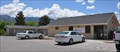
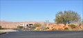
 view gallery view galleryN4.5 km | Beaver Dam Littlefield Fire District Station 1 in Firehouses Station Number 1 for the Beaver Dam/Littlefield Fire Department is located at 630 N Highway 91 in the small town of Beaver Dam, Arizona. posted by: brwhiz location: Arizona date approved: 11/27/2012 last visited: 05/10/2014 |
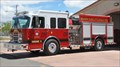 view gallery view galleryN4.5 km | Beaver Dam/Littlefield Engine 11 ~ Littlefield, Arizona in Fire Fighting Vehicles Engine Number 11 is the principal piece of firefighting gear used by this small, largely rural fire department. posted by: brwhiz location: Arizona date approved: 12/04/2012 last visited: 05/23/2017 |
 view gallery view galleryN4.5 km |  Beaver Dam - Littlefield, Arizona 86432 Beaver Dam - Littlefield, Arizona 86432
in U.S. Post Offices This small post office is located at 3288 E McKnight Road in Littlefield. posted by: brwhiz location: Arizona date approved: 07/07/2011 last visited: 12/19/2011 |
 view gallery view galleryN4.5 km |  Littlefield, Arizona Littlefield, Arizona
in Wikipedia Entries Littlefield and its companion community, Beaver Dam, are the only urban areas along Interstate 15 in Arizona. posted by: brwhiz location: Arizona date approved: 07/07/2011 last visited: 03/06/2018 |
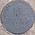 view gallery view gallery SW7.7 km SW7.7 km
| Arizona Highway Department Right-of-Way Marker POC+STA 127+00 in U.S. Benchmarks The angle iron witness post makes this ROW Marker stand out on the hillside north of Old US Highway 91 between Littlefield and Mesquite. posted by: brwhiz location: Arizona date approved: 03/25/2012 last visited: never |
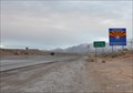
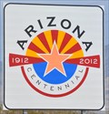 view gallery view gallerySW9.5 km |  Arizona Centennial Highway Sign Arizona Centennial Highway Sign
in Community Commemoration This highway sign announces Arizona's Centennial shortly after you leave Nevada headed east on Interstate 15. posted by: brwhiz location: Arizona date approved: 09/11/2013 last visited: 08/25/2017 |
 view gallery view galleryNE9.7 km |  A-10 Warthog crash site A-10 Warthog crash site
in Plane Crash Sites This is an A-10 Warthog crash site in mountainous terrain and burst into flames in the Virgin River Gorge. posted by: Lil Devil location: Arizona date approved: 08/15/2005 last visited: 10/28/2011 |
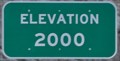 view gallery view galleryNE10.1 km |  Virgin River Gorge - Elevation 2000 Feet (I-15 Southbound) Virgin River Gorge - Elevation 2000 Feet (I-15 Southbound)
in Elevation Signs As you drop down the Virgin River Gorge from St. George, Utah, you pass through the 2000 foot level not far from the mouth of the Gorge. posted by: brwhiz location: Arizona date approved: 06/08/2011 last visited: 03/06/2018 |
 view gallery view gallerySW10.3 km | USCGS GR0094 ~ E 111 in U.S. Benchmarks This easy to spot Benchmark is on the north side of Old US Highway 91, across from the golf course, and about 1 3/4 miles east of Sandhill Blvd. in Mesquite. posted by: brwhiz location: Arizona date approved: 03/25/2012 last visited: 05/23/2017 |
 view gallery view gallerySW11.4 km | Arizona / Nevada State Line in U.S. Benchmarks A Benchmark at the Arizona / Nevada Line at a pull out on the freeway. posted by: JacobBarlow location: Nevada date approved: 08/16/2007 last visited: 09/24/2013 |
 view gallery view gallerySW11.4 km |  Arizona / Nevada Border - Interstate 15 Arizona / Nevada Border - Interstate 15
in Border Crossings There is a pull off on the Freeway at the Border Signs. posted by: JacobBarlow location: Arizona date approved: 08/16/2007 last visited: 12/24/2022 |
 view gallery view gallerySW11.6 km | Arizona in Wikipedia Entries This border crossing east of Mesquite, Nevada is just one of many major highways that lead into the great state of Arizona. posted by: brwhiz location: Arizona date approved: 06/09/2011 last visited: 12/21/2014 |
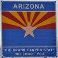 view gallery view gallerySW11.6 km |  Arizona ~ The Grand Canyon State Welcomes You Arizona ~ The Grand Canyon State Welcomes You
in Welcome Signs This Welcome Sign is on Interstate 15 as you travel east out of Mesquite, Nevada. posted by: brwhiz location: Arizona date approved: 06/11/2011 last visited: 11/21/2018 |
 view gallery view galleryW11.7 km |  Wolf Creek Golf Club Wolf Creek Golf Club
in Public and Private Golf Courses The Wolf Creek Golf Club is a beautiful, challenging golf course set high above town on the northeast edge of Mesquite, Nevada. posted by: brwhiz location: Nevada date approved: 09/25/2012 last visited: never |
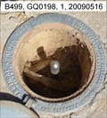 view gallery view galleryN12.6 km | B499, GQ0198 - Littlefield, AZ in U.S. Benchmarks A metal rod under a cap along old HWY 91. posted by: nvtriker location: Arizona date approved: 05/18/2009 last visited: 05/03/2014 |
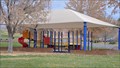 view gallery view gallerySW12.7 km |  Pioneer Park Playground Pioneer Park Playground
in Public Playgrounds This Playground is located near the western end of Pioneer Park, adjacent to Mesquite's city cemetery. posted by: brwhiz location: Nevada date approved: 09/24/2013 last visited: 09/24/2013 |
 view gallery view gallerySW12.7 km |  Eureka Casino Eureka Casino
in Neon Signs This large neon sign is at the south end of the portico at the main entrance to the Eureka Casino on Mesa Blvd in Mesquite, Nevada. posted by: brwhiz location: Nevada date approved: 04/21/2011 last visited: 02/13/2016 |
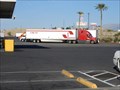 view gallery view gallerySW12.7 km |  Truck Stop - Mesquite, NV Truck Stop - Mesquite, NV
in Truck Stops Truck Stop - Mesquite posted by: ToRo61 location: Nevada date approved: 11/12/2017 last visited: never |
|