 view gallery view gallery E13.5 km E13.5 km
|   Leadfield, CA Leadfield, CA
in Wikipedia Entries This once was a huge mining town, but now, it is a ghost town. posted by:  bluesnote bluesnote location: California date approved: 02/21/2012 last visited: 03/17/2013 |
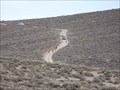
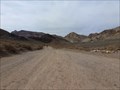
 view gallery view galleryE13.5 km | Titus Canyon - Death Valley National Park, CA in Wikipedia Entries This trail to the canyon can take 4x4 cars, but you can also Mountain Bike it like I did. posted by: bluesnote location: California date approved: 03/02/2012 last visited: 03/17/2013 |
 view gallery view galleryE13.5 km |  Leadfield, CA Leadfield, CA
in Ghost Towns This once was a huge mining town, but now, it is a ghost town. posted by: bluesnote location: California date approved: 02/24/2012 last visited: 03/17/2013 |
 view gallery view galleryE13.5 km |  Titus Canyon - Death Valley National Park, NV-CA Titus Canyon - Death Valley National Park, NV-CA
in Offroad Trails This trail can take 4x4 cars, but you can also Mountain Bike it like I did. posted by: bluesnote location: California date approved: 03/03/2012 last visited: 10/11/2015 |
 view gallery view galleryE13.5 km |  Leadfield, CA Leadfield, CA
in Roadside Attractions This once was a huge mining town, but now, it is a ghost town. posted by: bluesnote location: California date approved: 03/02/2012 last visited: 03/17/2013 |
 view gallery view galleryE13.5 km |  Leadfield, CA Leadfield, CA
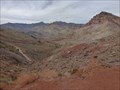
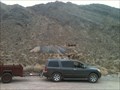
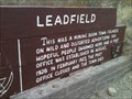
in U.S. National Register of Historic Places Located about 17 miles from highway 374 in Titus Canyon, Leadfield was once a huge mining town, but now, it is a ghost town. posted by: bluesnote location: California date approved: 03/02/2012 last visited: 03/17/2013 |
 view gallery view galleryE13.5 km |  Titus Canyon - Death Valley National Park, CA Titus Canyon - Death Valley National Park, CA
in Official Local Tourism Attractions This trail can take 4x4 cars, but you can also Mountain Bike it like I did. posted by: bluesnote location: California date approved: 03/03/2012 last visited: 03/17/2013 |
 view gallery view galleryE13.5 km |  Leadfield, CA Leadfield, CA
in Mines This mine is located about 17 miles from highway 374. posted by: bluesnote location: California date approved: 02/24/2012 last visited: 03/17/2013 |
 view gallery view galleryE13.5 km |  Titus Canyon - Death Valley National Park, CA Titus Canyon - Death Valley National Park, CA
in Places of Geologic Significance Titus Canyon has been cut by water for millions of years, now you can see rock that are half a billion years old! posted by: bluesnote location: California date approved: 04/08/2012 last visited: 03/17/2013 |
 view gallery view galleryE13.5 km |  Leadfield, CA Leadfield, CA
in Signs of History This once was a huge mining town, but now, it is a ghost town. posted by: bluesnote location: California date approved: 03/02/2012 last visited: 03/17/2013 |
 view gallery view galleryE21.1 km |  Titus Canyon Border Crossing - Death Valley National Park, CA/NV Titus Canyon Border Crossing - Death Valley National Park, CA/NV
in Border Crossings This is on a public road that has about 100-200 visitors each day. It is very well maintained, so don't worry. posted by: bluesnote location: Nevada date approved: 04/07/2012 last visited: 03/17/2013 |
 view gallery view gallery NW22.2 km NW22.2 km
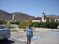
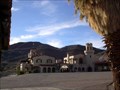
|  Scotty's Castle Scotty's Castle
in Castles While on an expedition with OffroadPassport.com we visited a castle in Death Valley California. A facinating story of lasting friendship is tied to this castle. posted by:  dzjeepchic dzjeepchic location: California date approved: 09/07/2009 last visited: 02/17/2014 |
 view gallery view galleryNW22.2 km |  Scotty's Castle, Death Valley National Park Scotty's Castle, Death Valley National Park
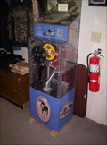
in Penny Smashers This penny smasher is located in the gift shop of the historic Scotty's Castle. posted by: Touchstone location: California date approved: 11/30/2005 last visited: 05/28/2012 |
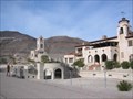 view gallery view galleryNW22.2 km | Death Valley Scotty Historic District in U.S. National Register of Historic Places An amazing castle built in the north end of Death Valley as a winter home for a Chicago millionaire, but named after the tale spinning prospector who lured him out to Death Valley. posted by: rambles location: California date approved: 01/25/2008 last visited: 04/28/2012 |
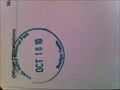 view gallery view galleryNW22.4 km |  Death Valley National Park - Scottys Castle Death Valley National Park - Scottys Castle
in NPS Passport Cancellation Stations Scotty's Castle posted by: left7 location: California date approved: 05/18/2011 last visited: 04/10/1999 |
 view gallery view galleryNW22.4 km | Scotty's Castle - Death Valley, CA in Roadside Attractions Scotty's Castle is located on the northeastern end of Death Valley National Park in CA at 123 Scotty's Castle Road with access from SR 267. posted by:  neoc1 neoc1 location: California date approved: 04/23/2014 last visited: 01/14/2012 |
 view gallery view gallery SE24.8 km SE24.8 km
|  Val Nolan - Death Valley, CA Val Nolan - Death Valley, CA
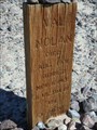
in Graves Mentioning a Cause of Death Lonely gravesite of Val Nolan, a miner who was buried where he died, after succumbing to the harsh elements in Death Valley. posted by: jiggs11 location: California date approved: 05/08/2017 last visited: never |
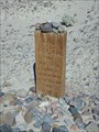 view gallery view gallerySE24.8 km |  Val Nolan - Death Valley, CA Val Nolan - Death Valley, CA
in Out of Place Graves Lonely gravesite of Val Nolan, a miner who was buried where he died in Death Valley. posted by: jiggs11 location: California date approved: 05/10/2017 last visited: never |
 view gallery view gallerySE25.3 km |  Old Stovepipe Wells No 826 - Death Valley, CA Old Stovepipe Wells No 826 - Death Valley, CA
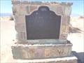
in California Historical Markers Marker describing the origin of the original Stovepipe Wells in Death Valley NP. posted by: jiggs11 location: California date approved: 05/08/2017 last visited: 04/22/2022 |
 view gallery view gallerySE25.6 km |  Hell's Gate - Death Valley National Park, CA Hell's Gate - Death Valley National Park, CA
in Geological Devilish Locations The northwest entrance to Death Valley National Park is known as Hell's Gate - in Death Valley National Park, California. posted by: The Snowdog location: Nevada date approved: 01/04/2023 last visited: never |
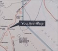 view gallery view gallerySE25.6 km |  You Are Here - Hell's Gate, Death Valley National Park, CA You Are Here - Hell's Gate, Death Valley National Park, CA
in 'You Are Here' Maps This "You Are Here" Map is near the northwest entrance to Death Valley National Park, California. posted by: The Snowdog location: California date approved: 01/04/2023 last visited: never |
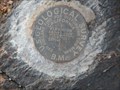 view gallery view gallerySE25.7 km |  USGS BM GS0952 - Hell's Gate - Death Valley, CA USGS BM GS0952 - Hell's Gate - Death Valley, CA
in U.S. Benchmarks A United States Geological Survey Benchmark set off Daylight Pass Road in the Hell's Gate region of northern Death Valley National Park. posted by: jiggs11 location: California date approved: 05/01/2017 last visited: never |
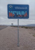 view gallery view galleryE26.2 km | Nevada / California on U.S. 374 - Death Valley National Park in Border Crossings U.S. 374 crosses the border between Nevada and California at this location - in Amargosa Valley, NV/CA. posted by: The Snowdog location: California date approved: 01/04/2023 last visited: never |
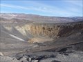 view gallery view galleryNW27 km | Ubehebe Crater - Death Valley National Park, CA in Wikipedia Entries Death Valley has many dangers (extreme heat, extreme cold, extreme droughts, etc.) but a new danger is coming that very few people know about. Are people ready for the next eruption of Ubehebe crater? posted by: bluesnote location: California date approved: 03/02/2012 last visited: 03/27/2015 |
 view gallery view galleryNW27 km |  As if Death Valley Wasn't Dangerous Enough... Geologists Discover That one of its Volcanoes is Due to go Off - Death Valley National Park, CA As if Death Valley Wasn't Dangerous Enough... Geologists Discover That one of its Volcanoes is Due to go Off - Death Valley National Park, CA
in News Article Locations Death Valley has many dangers (extreme heat, extreme cold, extreme droughts, ect.) but a new danger is coming that very few people know about. Are people ready for the eruption of Ubehebe crater? posted by: bluesnote location: California date approved: 03/02/2012 last visited: 03/27/2015 |
|