 view gallery view gallery NE20.9 km NE20.9 km
|   Leadfield, CA Leadfield, CA
in Wikipedia Entries This once was a huge mining town, but now, it is a ghost town. posted by:  bluesnote bluesnote location: California date approved: 02/21/2012 last visited: 03/17/2013 |
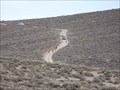
 view gallery view galleryNE20.9 km | Titus Canyon - Death Valley National Park, CA in Wikipedia Entries This trail to the canyon can take 4x4 cars, but you can also Mountain Bike it like I did. posted by: bluesnote location: California date approved: 03/02/2012 last visited: 03/17/2013 |
 view gallery view galleryNE20.9 km |  Leadfield, CA Leadfield, CA
in Ghost Towns This once was a huge mining town, but now, it is a ghost town. posted by: bluesnote location: California date approved: 02/24/2012 last visited: 03/17/2013 |
 view gallery view galleryNE20.9 km |  Titus Canyon - Death Valley National Park, NV-CA Titus Canyon - Death Valley National Park, NV-CA
in Offroad Trails This trail can take 4x4 cars, but you can also Mountain Bike it like I did. posted by: bluesnote location: California date approved: 03/03/2012 last visited: 10/11/2015 |
 view gallery view galleryNE20.9 km |  Leadfield, CA Leadfield, CA
in Roadside Attractions This once was a huge mining town, but now, it is a ghost town. posted by: bluesnote location: California date approved: 03/02/2012 last visited: 03/17/2013 |
 view gallery view galleryNE20.9 km |  Leadfield, CA Leadfield, CA
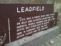
in U.S. National Register of Historic Places Located about 17 miles from highway 374 in Titus Canyon, Leadfield was once a huge mining town, but now, it is a ghost town. posted by: bluesnote location: California date approved: 03/02/2012 last visited: 03/17/2013 |
 view gallery view galleryNE20.9 km |  Titus Canyon - Death Valley National Park, CA Titus Canyon - Death Valley National Park, CA
in Official Local Tourism Attractions This trail can take 4x4 cars, but you can also Mountain Bike it like I did. posted by: bluesnote location: California date approved: 03/03/2012 last visited: 03/17/2013 |
 view gallery view galleryNE20.9 km |  Leadfield, CA Leadfield, CA
in Mines This mine is located about 17 miles from highway 374. posted by: bluesnote location: California date approved: 02/24/2012 last visited: 03/17/2013 |
 view gallery view galleryNE20.9 km |  Titus Canyon - Death Valley National Park, CA Titus Canyon - Death Valley National Park, CA
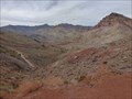
in Places of Geologic Significance Titus Canyon has been cut by water for millions of years, now you can see rock that are half a billion years old! posted by: bluesnote location: California date approved: 04/08/2012 last visited: 03/17/2013 |
 view gallery view galleryNE20.9 km |  Leadfield, CA Leadfield, CA
in Signs of History This once was a huge mining town, but now, it is a ghost town. posted by: bluesnote location: California date approved: 03/02/2012 last visited: 03/17/2013 |
 view gallery view gallery SE21.1 km SE21.1 km
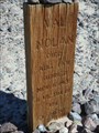
|  Val Nolan - Death Valley, CA Val Nolan - Death Valley, CA
in Graves Mentioning a Cause of Death Lonely gravesite of Val Nolan, a miner who was buried where he died, after succumbing to the harsh elements in Death Valley. posted by: jiggs11 location: California date approved: 05/08/2017 last visited: never |
 view gallery view gallerySE21.1 km |  Val Nolan - Death Valley, CA Val Nolan - Death Valley, CA
in Out of Place Graves Lonely gravesite of Val Nolan, a miner who was buried where he died in Death Valley. posted by: jiggs11 location: California date approved: 05/10/2017 last visited: never |
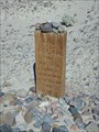
 view gallery view gallerySE21.2 km |  Old Stovepipe Wells No 826 - Death Valley, CA Old Stovepipe Wells No 826 - Death Valley, CA
in California Historical Markers Marker describing the origin of the original Stovepipe Wells in Death Valley NP. posted by: jiggs11 location: California date approved: 05/08/2017 last visited: 04/22/2022 |
 view gallery view gallerySE21.4 km |  Death Valley National Park - Stovepipe Wells NPS Stamp Death Valley National Park - Stovepipe Wells NPS Stamp
in NPS Passport Cancellation Stations The Stovepipe Wells NPS Passport Cancellation Station is inside the Stovepipe Wells Ranger Station near the west entrance to Death Valley National Park on Highway 190. posted by: shell1fish location: California date approved: 03/26/2013 last visited: 01/04/2023 |
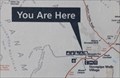 view gallery view gallerySE21.4 km |  You Are Here - Stovepipe Wells, CA You Are Here - Stovepipe Wells, CA
in 'You Are Here' Maps This "You Are Here" map indicates that your current location is Stovepipe Wells - in Death Valley National Park, California. posted by: The Snowdog location: California date approved: 01/04/2023 last visited: never |
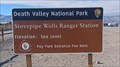 view gallery view gallerySE21.4 km |  Stovepipe Wells Ranger Station - Death Valley National Park, CA Stovepipe Wells Ranger Station - Death Valley National Park, CA
in Ranger Stations The Stovepipe Wells Ranger Station offers a place to pay your park entrance fee, stamp your National Park Passport, and pick up a map - in Death Valley National Park, California. posted by: The Snowdog location: California date approved: 01/06/2023 last visited: never |
 view gallery view gallerySE21.4 km | Stovepipe Wells, California in Wikipedia Entries Stovepipe Wells is a small way-station in the northern part of Death Valley, in unincorporated Inyo County, California. posted by: ChapterhouseInc location: California date approved: 02/24/2011 last visited: 04/07/2022 |
 view gallery view gallerySE21.4 km |  Sea Level - Stovepipe Wells Ranger Station - Death Valley National Park, CA Sea Level - Stovepipe Wells Ranger Station - Death Valley National Park, CA
in Elevation Signs The sign at the Stovepipe Wells Ranger Station gives the elevation as "Sea Level" - in Death Valley National Park, California. posted by: The Snowdog location: California date approved: 01/04/2023 last visited: 04/07/2022 |
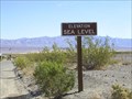 view gallery view gallerySE21.4 km | Death Valley Sea Level #1 in Elevation Signs Sea Level sign at Stovepipe Wells in Death Valley. posted by: Six Little Spookies location: California date approved: 03/26/2008 last visited: 05/28/2012 |
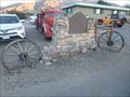 view gallery view gallerySE21.4 km |  Wagon Wheels - Burned Wagons Point Historic Marker - Stovepipe Wells, CA Wagon Wheels - Burned Wagons Point Historic Marker - Stovepipe Wells, CA
in Wagon Wheels A pair of old wagon wheels complementing the "Burned Wagons Point" historic Marker in Stovepipe Wells. posted by: jiggs11 location: California date approved: 05/09/2017 last visited: 04/07/2022 |
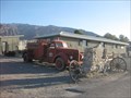
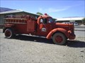 view gallery view gallerySE21.6 km |  Fire Truck, Stovepipe Wells, CA Fire Truck, Stovepipe Wells, CA
in Fire Fighting Vehicles Old fire truck in Stovepipe Wells, CA, in Death Valley. posted by: Six Little Spookies location: California date approved: 03/29/2008 last visited: 04/07/2022 |
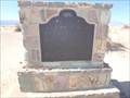
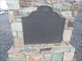
 view gallery view gallerySE21.6 km | Burned Wagons Point - Stovepipe Wells, CA in California Historical Markers Historical marker number 441 located in Stovepipe Wells, CA, inside Death Valley. posted by: Six Little Spookies location: California date approved: 04/03/2008 last visited: 04/07/2022 |
 view gallery view gallerySE21.6 km |  Stovepipe Wells - Death Valley National Park, CA Stovepipe Wells - Death Valley National Park, CA
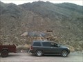
in Dog Friendly Hotels Stovepipe Wells has the only dog-friendly motel in Death Valley National Park. Dawg has stayed here several times. Dogs...beware of the resident coyotes! Once they stalked Dawg while she was peeing near the bushes outside of her room! posted by:  Team Min Dawg Team Min Dawg location: California date approved: 04/26/2010 last visited: 04/02/2011 |
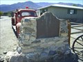
 view gallery view gallerySE21.6 km | Eichbaum Toll Road - Stovepipe Wells, CA in California Historical Markers Historic Marker recounting the establishment of the first tourist toll road into Death Valley. posted by: jiggs11 location: California date approved: 05/09/2017 last visited: never |
 view gallery view gallerySE21.6 km |  Stovepipe Wells, Death Valley, CA Stovepipe Wells, Death Valley, CA
in Payphones The payphone in the motel at Stovepipe Wells Village. We love that Death Valley and San Diego have the same area code! You'll need to use this one, too, as cell phone service is pretty much zero. posted by: Team Taskmaster location: California date approved: 04/05/2006 last visited: 12/30/2011 |
|