 view gallery view gallery S2.7 km S2.7 km
|   Los Ojos, New Mexico 87551 Los Ojos, New Mexico 87551
in U.S. Post Offices This Post Office is located at 95 State Road 514 in Los Ojos, New Mexico. posted by:  brwhiz brwhiz location: New Mexico date approved: 10/27/2011 last visited: never |
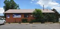
 view gallery view galleryS3.5 km |  Fort Lowell Fort Lowell
in New Mexico Historical Markers This New Mexico Official Scenic Historic Marker is located on the west side of US Highway 84 just south of the junction with New Mexico Highway 112 south of Los Ojos. The reverse side shows the location of other similar markers in the general area. posted by: brwhiz location: New Mexico date approved: 11/05/2012 last visited: never |
 view gallery view galleryS3.9 km | Tierra Amarilla, New Mexico 87575 in U.S. Post Offices This Post Office is located at 17306 US Highway 64/84 in Tierra Amarilla, New Mexico. posted by: brwhiz location: New Mexico date approved: 10/27/2011 last visited: never |
 view gallery view galleryS7.9 km | Tierra Amarilla in New Mexico Historical Markers This New Mexico Official Scenic Historic Marker is located on the east side of US Highway 84 at the junction with New Mexico Highway 162 south of Tierra Amarilla. The reverse side shows the location of other similar markers in the general area. posted by: brwhiz location: New Mexico date approved: 11/05/2012 last visited: never |
 view gallery view galleryS7.9 km |  Tierra Amarilla ~ Elevation 7860 feet Tierra Amarilla ~ Elevation 7860 feet
in Elevation Signs This Historical Marker displaying the elevation of Tierra Amarilla is located on the east side of US Highway 84 at the junction with New Mexico Highway 162 south of Tierra Amarilla. posted by: brwhiz location: New Mexico date approved: 11/05/2012 last visited: never |
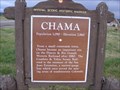 view gallery view gallery N11.9 km N11.9 km
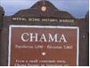
|  Chama, New Mexico, USA Chama, New Mexico, USA
in Population Signs Chama 1,090
Found on the highway when heading North into town posted by: WitzAbout location: New Mexico date approved: 08/30/2007 last visited: 08/06/2011 |
 view gallery view galleryN11.9 km | Chama in New Mexico Historical Markers New Mexico Historic Sign on the main highway into Chama,NM. posted by: kingbee location: New Mexico date approved: 07/18/2010 last visited: 08/31/2013 |
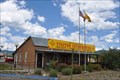
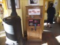
 view gallery view galleryN14.8 km |  Chamber of Commerce Visitor Center Penny Smasher Chamber of Commerce Visitor Center Penny Smasher
in Penny Smashers This Penny Smasher is in the Chamber of Commerce Visitor Center at 2372 US Highway 64 (at the junction of US Highway 64 and New Mexico Highway 17) in Chama, New Mexico. posted by: brwhiz location: New Mexico date approved: 10/03/2011 last visited: never |
 view gallery view galleryN14.8 km |  New Mexico Visitor Information Center New Mexico Visitor Information Center
in Tourist Information Centers - Visitor Centers This Visitor Information Center is operated by the Chama Chamber of Commerce and is located at 2372 US Highway 64 (at the junction of US Highway 64 and New Mexico Highway 17) in Chama, New Mexico. posted by: brwhiz location: New Mexico date approved: 11/07/2012 last visited: never |
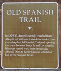 view gallery view galleryN14.8 km | Old Spanish Trail in New Mexico Historical Markers This New Mexico Official Scenic Historic Marker is located on the west side of the Chama Chamber of Commerce Visitor Information Center in Chama, New Mexico. The reverse side shows the location of other similar markers in the general area. posted by: brwhiz location: New Mexico date approved: 11/05/2012 last visited: never |
 view gallery view galleryN14.8 km |  Old Spanish Trail ~ Chama, New Mexico Old Spanish Trail ~ Chama, New Mexico
in Wagon Roads and Trails Antonio Armijo passed through the Chama, New Mexico area in 1829 as he established the Armijo Route of the Old Spanish Trail. posted by: brwhiz location: New Mexico date approved: 11/06/2012 last visited: never |
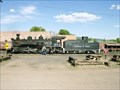
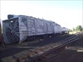 view gallery view galleryN16.7 km |  Rotary OY Snowplow - Cumbres and Toltec Scenic Railroad - Chama NM Rotary OY Snowplow - Cumbres and Toltec Scenic Railroad - Chama NM
in Railroad Maintenance-Of-Way Equipment This Rotary Snowplow is on display in the yard of the Combres and Toltec scenic railroad. posted by:  GT.US GT.US location: New Mexico date approved: 08/16/2011 last visited: never |
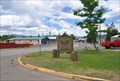
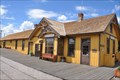
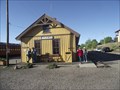
 view gallery view galleryN16.7 km |  Chama, New Mexico Chama, New Mexico
in Train Stations/Depots The Chama station of the Cumbres & Toltec Scenic Railroad is located at 500 Terrace Avenue in Chama, New Mexico. posted by: brwhiz location: New Mexico date approved: 02/06/2013 last visited: never |
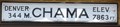 view gallery view galleryN16.7 km | Chama ~ Elevation 7863 Feet in Elevation Signs This Elevation sign is mounted on the east side of the Chama station of the Cumbres & Toltec Scenic Railroad at 500 Terrace Avenue in Chama, New Mexico. posted by: brwhiz location: New Mexico date approved: 02/06/2013 last visited: never |
 view gallery view galleryN16.7 km |  Denver & Rio Grande Railroad San Juan Extension ~ Chama, New Mexico Denver & Rio Grande Railroad San Juan Extension ~ Chama, New Mexico
in U.S. National Register of Historic Places The Denver & Rio Grande Railroad San Juan Extension, better known as the Cumbres & Toltec Scenic Railroad, has its southern terminus at the Chama station located at 500 Terrace Avenue in Chama, New Mexico. posted by: brwhiz location: New Mexico date approved: 02/06/2013 last visited: never |
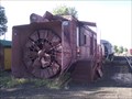 view gallery view galleryN16.7 km | Rotary OM Snowplow - Cumbres and Toltec Scenic Railroad - Chama NM in Railroad Maintenance-Of-Way Equipment This Rotary Snowplow is on display in the yard of the Combres and Toltec scenic railroad. posted by: GT.US location: New Mexico date approved: 08/16/2011 last visited: 06/08/2012 |
 view gallery view galleryN16.7 km | Cumbres & Toltec Scenic Railroad in Scenic Railroads The Cumbres and Toltec Scenic Railroad is both the highest and longest narrow gauge railroad in the United States. On its 64 mile trip, it crosses over the beautiful Cumbres Pass at 10,015 feet, posted by: DjARoswell location: New Mexico date approved: 07/01/2006 last visited: 07/22/2011 |
 view gallery view galleryN16.7 km | Railroad Penny Smasher - Cumbres and Toltec scenic railroad - Chamas, NM in Penny Smashers This penny smasher was found inside the Cumbres & Toltec Scenic railroad ticket office. posted by: GT.US location: New Mexico date approved: 08/15/2011 last visited: 06/08/2012 |
 view gallery view galleryN16.7 km |  Cumbres and Toltec Scenic Railroad, Chama NM Cumbres and Toltec Scenic Railroad, Chama NM
in Engineering Landmarks The Combres and Toltec Scenic railroad was added to the list of Historic Civil Engineering Landmarks as designated by the American Society of Civil Engineers in 1976. posted by: GT.US location: New Mexico date approved: 08/11/2011 last visited: 07/22/2011 |
 view gallery view galleryN16.9 km | The Hotel & Shops Penny Smasher in Penny Smashers This Penny Smasher is in The Hotel & Shops (the Shamrock Hotel) at 501 S Terrace Avenue (New Mexico Highway 17) in Chama, New Mexico. posted by: brwhiz location: New Mexico date approved: 10/03/2011 last visited: never |
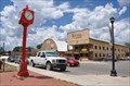 view gallery view galleryN16.9 km |  Village of Chama Clock ~ Chama, New Mexico Village of Chama Clock ~ Chama, New Mexico
in Town Clocks This beautiful, new, bright-red town clock stands on the east side of Terrace Avenue at 5th Street in downtown Chama, New Mexico. posted by: brwhiz location: New Mexico date approved: 11/06/2012 last visited: never |
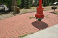 view gallery view galleryN16.9 km |  Chama Town Clock ~ Chama, New Mexico Chama Town Clock ~ Chama, New Mexico
in Donated Engraved Bricks and Pavers The Donor Bricks testify to contributions toward the purchase and installation of the town clock at Terrace Avenue and 5th Street in downtown Chama, New Mexico. posted by: brwhiz location: New Mexico date approved: 11/06/2012 last visited: never |
 view gallery view galleryN16.9 km | Chama ~ Elevation 7850 Feet in Elevation Signs This New Mexico Historical Marker, with Population and Elevation, is located on the east side of Terrace Avenue (New Mexico Highway 17) at 5th Street in Chama, New Mexico. posted by: brwhiz location: New Mexico date approved: 02/06/2013 last visited: never |
 view gallery view galleryN16.9 km | Chama ~ Population 1199 in Population Signs This New Mexico Historical Marker, with Population and Elevation, is located on the east side of Terrace Avenue (New Mexico Highway 17) at 5th Street in Chama, New Mexico. posted by: brwhiz location: New Mexico date approved: 02/06/2013 last visited: never |
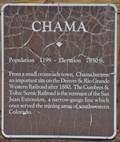 view gallery view galleryN16.9 km | Chama in New Mexico Historical Markers This New Mexico Historical Marker is located on the east side of Terrace Avenue (New Mexico Highway 17) at 5th Street in Chama, New Mexico. posted by: brwhiz location: New Mexico date approved: 02/06/2013 last visited: never |
|